METAR & TAF KGEG
Current METAR
Observed 14:53Z
KGEG 271453Z 15007KT 8SM FEW045 FEW090 FEW150 17/04 A3007 RMK AO2 SLP168 FU FEW045 FU FEW090 FU HZ ALQDS T01670044 53014 $
- Wind
- 150° @ 7 kt
- Visibility
- 8 SM
- Temp / Dew
- 17°C / 4°C
- Altimeter
- 30.07 inHg
- Clouds
- FEW
- Density alt
- 3,011 ft
- Ceiling
- Unlimited
- Rules
- VFR
Airport info & contacts
Manager on record, flight service, ARTCC, attendance schedule and pattern altitude — published by the FAA and refreshed every 28 days.
Location
- From city
- 5 NM SW
- VFR sectional
- SEATTLE
- ARTCC
- ZSE · SEATTLE
- NOTAM facility
- GEG (NOTAM-D)
Airport manager
- Name
- DAVID HARING
- Phone
- 509-455-6455
- Address
- 9000 W AIRPORT DR., SUITE 204, SPOKANE WA 99224
Flight service · Hours
- FSS SEA
- SEATTLE1-800-WX-BRIEF
- Attendance
- ALL
Frequencies
Tap any row to copy the frequency to your clipboard.
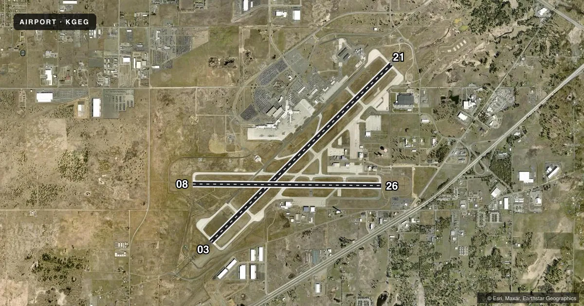
Runways & pattern
Full pagePattern entry · RWY 08
RIGHT TRAFFIC| Runway | Heading (°M) | Length | Surface | Traffic |
|---|---|---|---|---|
| 03/21 | 31° / 211° | 11,002 ft | ASPH-CONC | 03 R |
| 08/26Favored | 76° / 256° | 8,199 ft | ASPH | 08 R |
Runway end performance
| End | TORA | TODA | ASDA | LDA | VGSI | Approach lights | Obstruction |
|---|---|---|---|---|---|---|---|
| 03 | 11,002' | 11,002' | 11,002' | 11,002' | PAPI 4-box left(3°) | ALSF2 | — |
| 21 | 11,002' | 11,002' | 11,002' | 11,002' | PAPI 4-box left(3°) | ALSF2 | 9', gnd, 325' from thr, 500' R of cntrln, slope 13 |
| 08 | 8,199' | 8,199' | 8,199' | 8,199' | PAPI 4-box right(3°) | — | — |
| 26 | 8,199' | 8,199' | 8,199' | 8,199' | PAPI 4-box left(3°) | — | — |
Declared distances in feet. TORA = takeoff run available, TODA = takeoff distance, ASDA = accelerate-stop, LDA = landing distance.
Airport sketch
Runways drawn to scale from FAA survey coordinates, rendered over satellite imagery. Not for navigation.
Approaches & charts
ILS · 2
Services on the field
Fuel grades, oxygen, maintenance, ramp storage and lighting — as declared to the FAA by the airport operator.
Fuel & services
- Fuel
- 100100LLA
- Oxygen (bottled)
- HIGH/LOW
- Oxygen (bulk)
- HIGH/LOW
- Airframe repair
- Major
- Power plant repair
- Major
- Other services
- AFRT,AVNCS,CARGO,INSTR,RNTL,SALES
Ramp & ground
- Transient storage
- Tie-down
- Hangar
- Landing fee
- No fee published
- Customs
- Not available
- Beacon schedule
- SS-SR
- Beacon
- White / Green (civil land)(WG)
- Wind indicator
- Lighted
- Segmented circle
- No
Fuel & FBOs
Cheapest 100LL and Jet A on the field and nearby. Always confirm with the FBO before taxi.
Airport notes
Surface conditions, obstructions, local procedures, lighting outages and other notes published with each FAA cycle.
General notes
- BE ALERT TO TURBULENCE OVER SMOKE STACKS 1 MILE EAST OF ARPT.
- WATERFOWL & BIRDS ON & INVOF ARPT.
- TWY K UNLGTD ON RAMP SIDE ALONG MAINTENANCE RAMP AND IS UNAVBL BELOW 1200 RVR UNLESS UNDER ESCORT BY "FOLLOW ME".
- PORTIONS OF TWY K NOT VISIBLE FM ATCT.
Runway surface & condition
- 03/21PCR VALUE: 660/R/A/W/T
- 08/26PCR VALUE: 730/R/A/W/T
Approach & departure obstructions
- 21ALSF 2 MAY BE OPERATED AS SSALR DURING FAVORABLE WX CONDITIONS.
Other notes
- ESTABD PRIOR 1959
VFR map & nearby airports
VFR sectional. Tap any ICAO chip to open that airport.
Key facts · KGEG
Answer card- ICAO
- KGEG
- Name
- SPOKANE INTL
- Location
- SPOKANE, WASHINGTON
- Elevation
- 2,385 ft MSL
- Traffic pattern altitude
- 3,385 ft MSL (1,000 AGL)
- Control tower
- Towered · 24
- Total runways
- 2
- Longest runway
- 03/21 · 11,002 ft
- Published ILS approaches
- 2
- Published frequencies
- 19
- Magnetic variation
- 14°
- Current flight rules
- VFR
- Current wind
- 150° at 7 kt
- Favored runway now
- RWY 08
Spokane Intl sits in Spokane, Washington. The field elevation is 2,385 ft MSL. It has two runways. The longest is 03/21 at 11,002 ft. Runway 08/26 is 8,199 ft. The tower is open 24 hours. Two ILS approaches are published for runway ends 03 and 21.
For pattern work, the published pattern altitude is not given in the facts. Use the standard 1,000 ft AGL for light piston traffic unless the current Chart Supplement says otherwise. That puts the pattern at about 3,385 ft MSL here. Spokane sits in Class C airspace, so plan on talking to ATC early. Expect busy airline and business traffic. The airport also has published remarks that matter on the ground. Taxiway K has an unlighted section near the maintenance ramp. Some of it is not visible from the tower. Birds and waterfowl are also reported on and near the field. Smoke stacks about a mile east can add turbulence.
Signature Aviation is on the field and carries 100LL and Jet A. Aero Center is also on the field and carries 100LL, Jet A and Jet A Prist. If you are arriving at night or in low visibility, pay close attention to the lighting notes for runway 21. The approach lighting system there may be used in a simplified mode in good weather. For any current taxi or lighting detail that affects your arrival, verify with the airport operator or the FBO directly by phone.