METAR & TAF KCOE
Current METAR
Observed 15:56Z
KCOE 271556Z AUTO 18010KT 10SM FEW002 21/08 A3009 RMK AO2 SLP190 T02060083 PNO $
- Wind
- 180° @ 10 kt
- Visibility
- 10 SM
- Temp / Dew
- 21°C / 8°C
- Altimeter
- 30.09 inHg
- Clouds
- FEW
- Density alt
- 3,386 ft
- Ceiling
- Unlimited
- Rules
- VFR
Airport info & contacts
Manager on record, flight service, ARTCC, attendance schedule and pattern altitude — published by the FAA and refreshed every 28 days.
Location
- From city
- 9 NM NW
- VFR sectional
- GREAT FALLS
- ARTCC
- ZSE · SEATTLE
- NOTAM facility
- COE (NOTAM-D)
Airport manager
- Name
- GASTON PATTERSON
- Phone
- 208-446-1860
- Address
- 10375 SENSOR AVE, HAYDEN ID 83835
Flight service · Hours
- FSS BOI
- BOISE1-800-WX-BRIEF
- Attendance
- 0700-1700
Frequencies
Tap any row to copy the frequency to your clipboard.
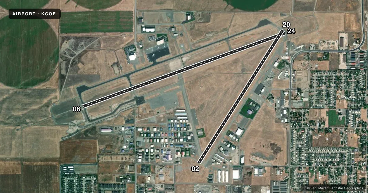
Runways & pattern
Full pagePattern entry · RWY 20
LEFT TRAFFIC| Runway | Heading (°M) | Length | Surface | Traffic |
|---|---|---|---|---|
| 06/24 | 51° / 231° | 7,400 ft | ASPH | Standard L |
| 02/20Favored | 13° / 193° | 5,400 ft | ASPH | 02 R |
Runway end performance
| End | TORA | TODA | ASDA | LDA | VGSI | Approach lights | Obstruction |
|---|---|---|---|---|---|---|---|
| 06 | 7,400' | 7,400' | 7,400' | 7,400' | PAPI 4-box right(3°) | MALSR | — |
| 24 | 7,400' | 7,400' | 7,400' | 7,400' | PAPI 4-box right(3°) | — | — |
| 02 | 5,400' | 5,400' | 5,400' | 5,400' | PAPI 2-box left(3°) | — | — |
| 20 | 5,400' | 5,400' | 5,400' | 5,400' | PAPI 2-box left(3°) | — | — |
Declared distances in feet. TORA = takeoff run available, TODA = takeoff distance, ASDA = accelerate-stop, LDA = landing distance.
Airport sketch
Runways drawn to scale from FAA survey coordinates, rendered over satellite imagery. Not for navigation.
Approaches & charts
ILS · 1
Services on the field
Fuel grades, oxygen, maintenance, ramp storage and lighting — as declared to the FAA by the airport operator.
Fuel & services
- Fuel
- 100A
- Oxygen (bottled)
- HIGH/LOW
- Oxygen (bulk)
- HIGH/LOW
- Airframe repair
- Major
- Power plant repair
- Major
- Other services
- AMB,AVNCS,CHTR,INSTR,RNTL,SALES
Ramp & ground
- Transient storage
- Tie-down
- Hangar
- Landing fee
- No fee published
- Customs
- Not available
- Lighting schedule
- SEE RMK
- Beacon schedule
- SS-SR
- Beacon
- White / Green (civil land)(WG)
- Wind indicator
- Lighted
- Segmented circle
- Yes
Fuel & FBOs
Cheapest 100LL and Jet A on the field and nearby. Always confirm with the FBO before taxi.
Airport notes
Surface conditions, obstructions, local procedures, lighting outages and other notes published with each FAA cycle.
General notes
- MIGRATORY BIRDS ON & INVOF ARPT OCT-NOV.
- RWY: CONDS NOT MNTD 5 PM TO 7 AM DLY.
- FOR CD IF UNA CTC ON 132.1 CTC SPOKANE APCH AT 509-742-2522.
- PJE IN VCNTY.
Lighting notes
- ACTVT MIRL RWY 02/20, HIRL RWY 06/24, REIL RWYS 02 & 24, & MALSR RWY 06 - CTAF. PAPI RWYS 02, 20, 06, & 24 OPER CONTINUOUSLY.
Fuel notes
- 100AFT HRS FUEL. SELF SVC AVBL WITH CREDIT CARD.
Runway surface & condition
- 02/20PCR VALUE: 600/F/B/X/T
- 06/24PCR VALUE: 470/F/A/X/T
Approach & departure obstructions
- 06RWY 06 NSTD MALSR; THLD BAR EXTENDS 5 FT BYD RWY EDGE LGTS EACH SIDE.
Other notes
- 48 HR PPR FOR UNSKED OPNS WITH MORE THAN 30 PSGR SEATS CALL AMGR 208-446-1860.
VFR map & nearby airports
VFR sectional. Tap any ICAO chip to open that airport.
Key facts · KCOE
Answer card- ICAO
- KCOE
- Name
- COEUR D'ALENE
- Location
- COEUR D'ALENE, IDAHO
- Elevation
- 2,320.3 ft MSL
- Traffic pattern altitude
- 3,320.3 ft MSL (1,000 AGL)
- Control tower
- Non-towered (use CTAF)
- Total runways
- 2
- Longest runway
- 06/24 · 7,400 ft
- Published ILS approaches
- 1
- Published frequencies
- 4
- Magnetic variation
- 19°
- Current flight rules
- VFR
- Current wind
- 180° at 10 kt
- Favored runway now
- RWY 20
Coeur d'Alene/Pappy Boyington Fld is in Coeur d'Alene, Idaho. Field elevation is 2,320.3 ft MSL. The airport has two asphalt runways. The longest is 7,400 ft on 06/24. There is no control tower. Spokane Approach handles approach and departure services on 132.1 MHz and 263.0 MHz. One ILS is published for runway 06.
Pattern altitude is not published. Use 1,000 ft AGL for light piston traffic unless local procedures or ATC tell you otherwise. StanCraft Jet Center is on the field. It carries 100LL, Jet A and Jet A Prist. After hours fuel and self-service are available with a credit card. Runway 06 has a nonstandard medium intensity approach lighting system with runway alignment indicator lights. Runway lights are controlled by CTAF. PAPI is listed on all runway ends.
This is a high-elevation field with mountain flying considerations. Expect performance planning to matter. Birds are reported in the area during October and November. Parachute jumping also occurs nearby. Runway conditions are not maintained daily from 5 PM to 7 AM. If you need clearance delivery and it is not available on 132.1, contact Spokane Approach at 509-742-2522. Check the current FAA Chart Supplement for any published noise or curfew restrictions before flying into the field.