METAR & TAF S72
S72 does not publish a METAR.
Showing the nearest reporting station: KCOE (COEUR D'ALENE) · 28.7 NM away. Conditions at S72 may differ.
METAR · KCOE
Observed 14:56Z
KCOE 271456Z AUTO 19005KT 10SM CLR 19/10 A3009 RMK AO2 SLP190 6//// T01890100 53015 PNO $
- Wind
- 190° @ 5 kt
- Visibility
- 10 SM
- Temp / Dew
- 19°C / 10°C
- Altimeter
- 30.09 inHg
- Clouds
- CLR
- Density alt
- 2,912 ft
- Ceiling
- Unlimited
- Rules
- VFR
Airport info & contacts
Manager on record, flight service, ARTCC, attendance schedule and pattern altitude — published by the FAA and refreshed every 28 days.
Location
- From city
- 1 NM NW
- VFR sectional
- GREAT FALLS
- ARTCC
- ZSE · SEATTLE
- NOTAM facility
- BOI (NOTAM-D)
Airport manager
- Name
- JIM ROLETTO
- Phone
- 208-967-4232
- Address
- 701 COLLEGE AVE, ST MARIES ID 83861
Flight service · Hours
- FSS BOI
- BOISE1-800-WX-BRIEF
- Attendance
- Unattended
Frequencies
Tap any row to copy the frequency to your clipboard.
Runways & pattern
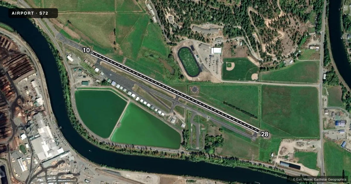
Full pagePattern entry · RWY 10
RIGHT TRAFFICRunway end performance
| End | TORA | TODA | ASDA | LDA | VGSI | Approach lights | Obstruction |
|---|---|---|---|---|---|---|---|
| 10 | — | — | — | — | — | — | 35', road, 825' from thr, 0' R of cntrln, slope 17 |
| 28 | — | — | — | — | — | — | 45', trees, 1700' from thr, 0' R of cntrln, slope 33 |
Declared distances in feet. TORA = takeoff run available, TODA = takeoff distance, ASDA = accelerate-stop, LDA = landing distance.
Airport sketch
Runways drawn to scale from FAA survey coordinates, rendered over satellite imagery. Not for navigation.
Approaches & charts
Services on the field
Fuel grades, oxygen, maintenance, ramp storage and lighting — as declared to the FAA by the airport operator.
Fuel & services
- Fuel
- 100LL
- Oxygen (bottled)
- Not available
- Oxygen (bulk)
- Not available
- Airframe repair
- Minor
- Power plant repair
- Minor
- Other services
- INSTR
Ramp & ground
- Transient storage
- Tie-down
- Landing fee
- No fee published
- Customs
- Not available
- Lighting schedule
- SEE RMK
- Beacon schedule
- SS-SR
- Beacon
- White / Green (civil land)(WG)
- Wind indicator
- Lighted
- Segmented circle
- Yes
Fuel & FBOs
Cheapest 100LL and Jet A on the field and nearby. Always confirm with the FBO before taxi.
Airport notes
Surface conditions, obstructions, local procedures, lighting outages and other notes published with each FAA cycle.
General notes
- RY 28 HAS 200 FT STOPWAY.
- FOR CD CTC SEATTLE ARTCC AT 253-351-3694.
Lighting notes
- ACTVT MIRL RWY 10/28 - CTAF.
Runway surface & condition
- 10/28FIRST 715 FT RWY 10 NOT LGTD.
Approach & departure obstructions
- 10NSTD DSPLCD THLD MARKING YELLOW CHEVRONS.
- 10DSPLCD FOR 35 FT ROAD AT 0 FT; 30 FT RIGHT; 23:1 FM DSPLCD THLD.
- 28ADDNL OBSTNS +50' PLINE AT 2000', ON CNTRLN +4' FENCE AT 275' ON CNTRLN, +1000' RIDGE AT 1 1/2 MILES, ON CNTRLN.
Other notes
- ESTABD PRIOR TO 15 MAY 59.
VFR map & nearby airports
VFR sectional. Tap any ICAO chip to open that airport.
Key facts · S72
Answer card- ICAO
- S72
- Name
- JACK A BUELL
- Location
- ST MARIES, IDAHO
- Elevation
- 2,131.3 ft MSL
- Traffic pattern altitude
- 3,131.3 ft MSL (1,000 AGL)
- Control tower
- Non-towered (use CTAF)
- Total runways
- 1
- Longest runway
- 10/28 · 3,354 ft
- Published ILS approaches
- 0
- Published frequencies
- 2
- Magnetic variation
- 15°
- Current flight rules
- VFR
- Current wind
- 190° at 5 kt
- Favored runway now
- RWY 10
Jack A Buell Airport sits in St Maries, Idaho. The field elevation is 2,131.3 ft MSL. It has one runway, 10/28, which is 3,354 ft long and asphalt. There is no control tower. CTAF and UNICOM are both 122.8. No ILS approaches are published.
Pattern altitude is not published. Use the standard 1,000 ft AGL unless the current Chart Supplement says otherwise. The on-field FBO listed here is St Maries Municipal Airport. It carries AVGAS 100LL. Call (208) 582-0941 before you go if you need current service details.
This field has a few items a first-time pilot should brief. Runway 10 has nonstandard displaced threshold markings with yellow chevrons. The first 715 ft of runway 10 is not lighted. Runway 10/28 lighting is medium intensity. It is activated by CTAF. Runway 28 has a 200 ft stopway. Published remarks also note obstructions on the 28 end, including a power line, a fence and a ridge on final. Clearance delivery is handled through Seattle ARTCC at 253-351-3694. Check the current Chart Supplement for any published noise or curfew restrictions before flying into the field.