METAR & TAF S83
S83 does not publish a METAR.
Showing the nearest reporting station: KCOE (COEUR D'ALENE) · 28.9 NM away. Conditions at S83 may differ.
METAR · KCOE
Observed 14:56Z
KCOE 271456Z AUTO 19005KT 10SM CLR 19/10 A3009 RMK AO2 SLP190 6//// T01890100 53015 PNO $
- Wind
- 190° @ 5 kt
- Visibility
- 10 SM
- Temp / Dew
- 19°C / 10°C
- Altimeter
- 30.09 inHg
- Clouds
- CLR
- Density alt
- 3,031 ft
- Ceiling
- Unlimited
- Rules
- VFR
Airport info & contacts
Manager on record, flight service, ARTCC, attendance schedule and pattern altitude — published by the FAA and refreshed every 28 days.
Location
- From city
- 3 NM W
- VFR sectional
- GREAT FALLS
- ARTCC
- ZSE · SEATTLE
- NOTAM facility
- BOI (NOTAM-D)
Airport manager
- Name
- RANDY CHILDRESS
- Phone
- 208-512-4260
- Address
- 926 AIRPORT RD, SMELTERVILLE 83868
Flight service · Hours
- FSS BOI
- BOISE1-800-WX-BRIEF
- Attendance
- DALGT
Frequencies
Tap any row to copy the frequency to your clipboard.
Runways & pattern
Full pagePattern entry · RWY 25
LEFT TRAFFICRunway end performance
| End | TORA | TODA | ASDA | LDA | VGSI | Approach lights | Obstruction |
|---|---|---|---|---|---|---|---|
| 07 | — | — | — | — | — | — | 35', tree, 360' from thr, 140' R of cntrln, slope 4 |
| 25 | — | — | — | — | — | — | 40', sign, 740' from thr, 0' R of cntrln, slope 13 |
Declared distances in feet. TORA = takeoff run available, TODA = takeoff distance, ASDA = accelerate-stop, LDA = landing distance.
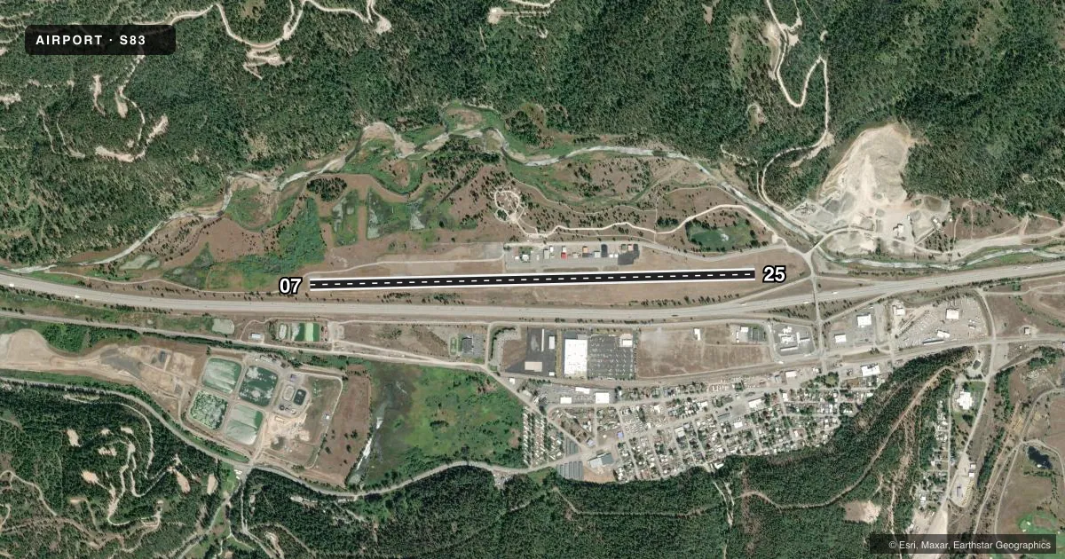
Airport sketch
Runways drawn to scale from FAA survey coordinates, rendered over satellite imagery. Not for navigation.
Approaches & charts
Services on the field
Fuel grades, oxygen, maintenance, ramp storage and lighting — as declared to the FAA by the airport operator.
Fuel & services
- Fuel
- 100LL
Ramp & ground
- Transient storage
- Tie-down
- Landing fee
- No fee published
- Customs
- Not available
- Lighting schedule
- SEE RMK
- Beacon schedule
- SS-SR
- Beacon
- White / Green (civil land)(WG)
- Wind indicator
- Lighted
- Segmented circle
- Yes
Fuel & FBOs
Cheapest 100LL and Jet A on the field and nearby. Always confirm with the FBO before taxi.
Airport notes
Surface conditions, obstructions, local procedures, lighting outages and other notes published with each FAA cycle.
General notes
- FOR CD CTC SEATTLE ARTCC AT 253-351-3694.
Lighting notes
- ACVT MIRL RWY 07/25 - CTAF.
Approach & departure obstructions
- 25APCH SLP 16:1 TO DTHR.
- 25+40 FT LGT POLE & TRRN ON CNTRLN 740 FT FM RWY END; +60 FT TREES AT 1500 FT ON CNTRLN.
VFR map & nearby airports
VFR sectional. Tap any ICAO chip to open that airport.
Key facts · S83
Answer card- ICAO
- S83
- Name
- SHOSHONE COUNTY
- Location
- KELLOGG, IDAHO
- Elevation
- 2,227 ft MSL
- Traffic pattern altitude
- 3,227 ft MSL (1,000 AGL)
- Control tower
- Non-towered (use CTAF)
- Total runways
- 1
- Longest runway
- 07/25 · 5,316 ft
- Published ILS approaches
- 0
- Published frequencies
- 2
- Magnetic variation
- 19°
- Current flight rules
- VFR
- Current wind
- 190° at 5 kt
- Favored runway now
- RWY 25
Shoshone County Airport is in Kellogg, Idaho. The field elevation is 2,227 ft MSL. It has one runway. Runway 07/25 is 5,316 ft long with an asphalt surface. There is no control tower. CTAF and UNICOM are both 122.8. No ILS approaches are published.
Pattern altitude is not published. Use 1,000 ft AGL as the standard light-piston pattern unless the current FAA Chart Supplement says otherwise. That puts the pattern at about 3,227 ft MSL. The on-field FBO is Shoshone County Airport. It carries 100LL. Call (208) 786-5381 for current service details.
A few published remarks matter here. The runway lights on 07/25 are medium intensity and are activated by CTAF. The approach to the displaced threshold has a steep slope. There is also a 40-foot light pole and terrain on the centerline 740 feet from the runway end. Trees on the centerline rise to 60 feet about 1,500 feet from the runway end. This is a field where a stabilized approach matters. The airport also notes clearance delivery through Seattle ARTCC at 253-351-3694. Check the current FAA Chart Supplement before departure for any changes to procedures or local notices.