METAR & TAF 73S
73S does not publish a METAR.
Showing the nearest reporting station: KSFF (FELTS FLD) · 29.1 NM away. Conditions at 73S may differ.
METAR · KSFF
Observed 15:53Z
KSFF 271553Z 19004KT 10SM CLR 22/06 A3007 RMK AO2 SLP169 T02170061
- Wind
- 190° @ 4 kt
- Visibility
- 10 SM
- Temp / Dew
- 22°C / 6°C
- Altimeter
- 30.07 inHg
- Clouds
- CLR
- Density alt
- 3,779 ft
- Ceiling
- Unlimited
- Rules
- VFR
Airport info & contacts
Manager on record, flight service, ARTCC, attendance schedule and pattern altitude — published by the FAA and refreshed every 28 days.
Location
- From city
- 2 NM NE
- VFR sectional
- SEATTLE
- ARTCC
- ZSE · SEATTLE
- NOTAM facility
- SEA (NOTAM-D)
Airport manager
- Name
- MIKE HALE
- Phone
- 509-322-8643
- Address
- PO BOX 927, TEKOA WA 99033
Flight service · Hours
- FSS SEA
- SEATTLE1-800-WX-BRIEF
- Attendance
- Unattended
Frequencies
Tap any row to copy the frequency to your clipboard.
Runways & pattern
Full pagePattern entry · RWY 22
LEFT TRAFFICRunway end performance
| End | TORA | TODA | ASDA | LDA | VGSI | Approach lights | Obstruction |
|---|---|---|---|---|---|---|---|
| 04 | — | — | — | — | — | — | 53', trees, 1195' from thr, 0' R of cntrln, slope 18 |
Declared distances in feet. TORA = takeoff run available, TODA = takeoff distance, ASDA = accelerate-stop, LDA = landing distance.
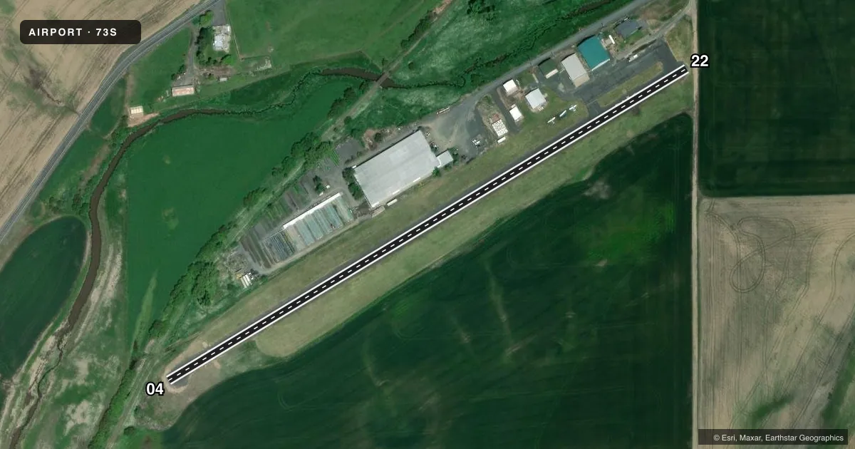
Airport sketch
Runways drawn to scale from FAA survey coordinates, rendered over satellite imagery. Not for navigation.
Approaches & charts
Services on the field
Fuel grades, oxygen, maintenance, ramp storage and lighting — as declared to the FAA by the airport operator.
Fuel & services
- Fuel
- 100LL
- Oxygen (bottled)
- Not available
- Oxygen (bulk)
- Not available
- Airframe repair
- Major
- Power plant repair
- Major
Ramp & ground
- Transient storage
- Tie-down
- Landing fee
- No fee published
- Customs
- Not available
- Lighting schedule
- SEE RMK
- Beacon schedule
- SS-SR
- Beacon
- White / Green (civil land)(WG)
- Wind indicator
- Yes
- Segmented circle
- No
Fuel & FBOs
Cheapest 100LL and Jet A on the field and nearby. Always confirm with the FBO before taxi.
Airport notes
Surface conditions, obstructions, local procedures, lighting outages and other notes published with each FAA cycle.
General notes
- GRASS AREAS NOT AVBL FOR ACFT OPS.
- FOR CD CTC SEATTLE ARTCC AT 253-351-3694.
Lighting notes
- ACTVT MIRL RY 04/22 - 122.8.
Fuel notes
- 100LLSELF SERVICE FUEL WITH CREDIT CARD.
Approach & departure obstructions
- 04RWY 04 DITCH, 42 FT L FM RWY END; 6-12 FT HIGH BRUSH, 0-200 FT FM THR.
- 22RWY 22 ACES ROAD, 33 FT FM RWY END.
Other notes
- ESTABD PRIOR TO 15 MAY 1959.
- PILOTS BRING OWN ROPES.
VFR map & nearby airports
VFR sectional. Tap any ICAO chip to open that airport.
Key facts · 73S
Answer card- ICAO
- 73S
- Name
- WILLARD FLD
- Location
- TEKOA, WASHINGTON
- Elevation
- 2,520 ft MSL
- Traffic pattern altitude
- 3,520 ft MSL (1,000 AGL)
- Control tower
- Non-towered (use CTAF)
- Total runways
- 1
- Longest runway
- 04/22 · 2,261 ft
- Published ILS approaches
- 0
- Published frequencies
- 1
- Magnetic variation
- 19°
- Current flight rules
- VFR
- Current wind
- 190° at 4 kt
- Favored runway now
- RWY 22
Willard Fld sits in Tekoa, Washington. Field elevation is 2,520 ft MSL. The airport has one runway, 04/22, which is 2,261 ft long and asphalt. There is no control tower. CTAF is 122.9. No ILS approaches are published here.
Pattern altitude is not published. Use the standard 1,000 ft AGL pattern unless the current Chart Supplement says otherwise. That puts the light piston pattern at 3,520 ft MSL based on the field elevation. Medium intensity runway lights are available on runway 04/22 by using 122.8. Self-service 100LL is available with credit card payment. There are no on-field FBOs listed.
This is a small field with some close-in hazards. Runway 04 has a ditch 42 ft left of the runway end plus brush 0 to 200 ft from the threshold. Runway 22 has Aces Road 33 ft from the runway end. Grass areas are not available for aircraft operations. Clearance delivery is handled through Seattle ARTCC at 253-351-3694. Bring your own ropes if you need them. The field is in a higher-elevation part of eastern Washington, so performance planning matters on warm days. Check the current FAA Chart Supplement for any local operating notes before you go.