METAR & TAF S94
S94 does not publish a METAR.
Showing the nearest reporting station: KPUW (PULLMAN/MOSCOW RGNL) · 14.3 NM away. Conditions at S94 may differ.
METAR · KPUW
Observed 09:53Z
KPUW 270953Z AUTO 00000KT 5SM HZ CLR 11/04 A3007 RMK AO2 SLP172 T01060044
- Wind
- 000° @ 0 kt
- Visibility
- 5 SM
- Temp / Dew
- 11°C / 4°C
- Altimeter
- 30.07 inHg
- Clouds
- CLR
- Density alt
- 2,038 ft
- Ceiling
- Unlimited
- Rules
- MVFR
Airport info & contacts
Manager on record, flight service, ARTCC, attendance schedule and pattern altitude — published by the FAA and refreshed every 28 days.
Location
- From city
- 3 NM SW
- VFR sectional
- SEATTLE
- Pattern altitude
- 829 ft AGL · 3,010 ft MSL
- ARTCC
- ZSE · SEATTLE
- NOTAM facility
- SEA (NOTAM-D)
Airport manager
- Name
- DARRELL FENDER
- Phone
- 509-397-2061
- Address
- PO BOX 143, COLFAX WA 99111
Flight service · Hours
- FSS SEA
- SEATTLE1-800-WX-BRIEF
- Attendance
- JAN-DEC · 0800L-1600L
Frequencies
Tap any row to copy the frequency to your clipboard.
Runways & pattern
Full pagePattern entry · RWY 08
LEFT TRAFFICRunway end performance
| End | TORA | TODA | ASDA | LDA | VGSI | Approach lights | Obstruction |
|---|---|---|---|---|---|---|---|
| 08 | 3,209' | 3,209' | 3,209' | 2,718' | — | — | 13', road, 316' from thr, 131' R of cntrln, slope 50 |
| 26 | 3,209' | 3,209' | 3,209' | 2,890' | — | — | 115', hill, 4000' from thr, 0' R of cntrln, slope 37 |
Declared distances in feet. TORA = takeoff run available, TODA = takeoff distance, ASDA = accelerate-stop, LDA = landing distance.
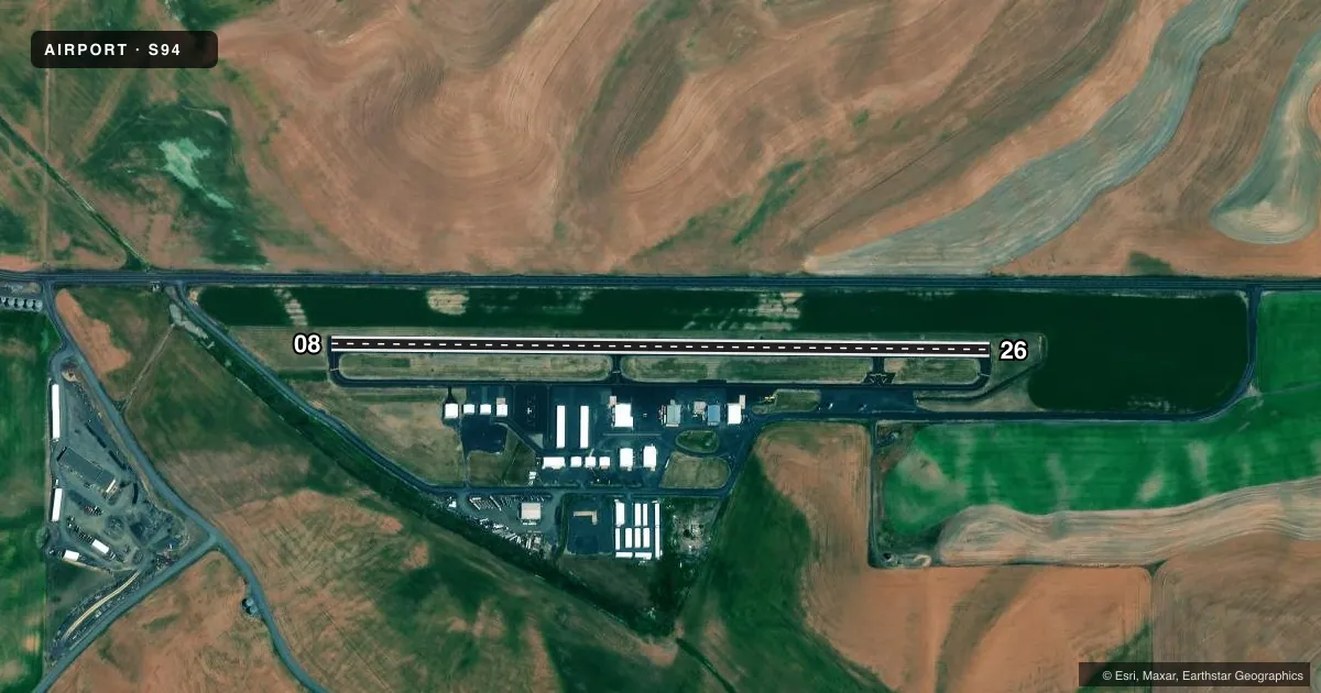
Airport sketch
Runways drawn to scale from FAA survey coordinates, rendered over satellite imagery. Not for navigation.
Approaches & charts
Services on the field
Fuel grades, oxygen, maintenance, ramp storage and lighting — as declared to the FAA by the airport operator.
Fuel & services
- Fuel
- Not available
- Oxygen (bottled)
- Not available
- Oxygen (bulk)
- Not available
- Airframe repair
- Not available
- Power plant repair
- Not available
- Other services
- AGRI
Ramp & ground
- Transient storage
- Tie-down
- Landing fee
- No fee published
- Customs
- Not available
- Lighting schedule
- SEE RMK
- Beacon schedule
- SS-SR
- Beacon
- White / Green (civil land)(WG)
- Wind indicator
- Lighted
- Segmented circle
- No
Fuel & FBOs
Cheapest 100LL and Jet A on the field and nearby. Always confirm with the FBO before taxi.
Airport notes
Surface conditions, obstructions, local procedures, lighting outages and other notes published with each FAA cycle.
General notes
- RY 08/26 FARM MACHINERY MAY BE OPERATING IN FIELDS ON BOTH SIDES OF RY AND OFF BOTH RY ENDS.
- 30 FT BLDG 250 FT S AER RY 26.
- WATCH FOR BIRDS INVOF CREEK SOUTH OF AIRPORT.
- DEER INVOF RWY.
- CALL AHD FOR COURTESY CAR AVBL. CALL 509--954-6881.
- DENSE AGRICULTURAL OPERATIONS FEBRUARY THROUGH OCTOBER.
- FOR CD CTC SEATTLE ARTCC AT 253-351-3694.
Lighting notes
- ACTVT MIRL RY 08/26 - CTAF.
Approach & departure obstructions
- 08APCH RATIO 50:1 FROM DSPLCD THLD.
- 26APCH RATIO 37:1 FROM DSPLCD THLD.
- 26HILLS
Other notes
- ESTABD PRIOR TO 15 MAY 1959.
VFR map & nearby airports
VFR sectional. Tap any ICAO chip to open that airport.
Key facts · S94
Answer card- ICAO
- S94
- Name
- PORT OF WHITMAN BUSINESS AIR CENTER
- Location
- COLFAX, WASHINGTON
- Elevation
- 2,181 ft MSL
- Traffic pattern altitude
- 3,010 ft MSL (829 AGL)
- Control tower
- Non-towered (use CTAF)
- Total runways
- 1
- Longest runway
- 08/26 · 3,209 ft
- Published ILS approaches
- 0
- Published frequencies
- 2
- Magnetic variation
- 19°
- Current flight rules
- MVFR
- Current wind
- 000° at 0 kt
- Favored runway now
- –
Port of Whitman Business Air Center is in Colfax, Washington. The field elevation is 2,181 ft MSL. It has one runway, 08/26, which is 3,209 ft of asphalt. There is no control tower. CTAF and UNICOM are both 122.8. No ILS approaches are published here.
The pattern altitude is 829 ft AGL, which puts it at 3,010 ft MSL. That matters here because the airport sits high enough to make density altitude a real planning item in warmer months. The runway environment also deserves a close look. FAA remarks call out hills near runway 26. They also note a 30-foot building south of the runway, deer in the area, birds near the creek south of the airport and farm machinery operating in the fields on both sides of the runway and off both ends. Medium intensity runway lights on 08/26 are activated by CTAF.
No on-field FBOs are listed. Call the airport operator directly before arrival for current services. FAA remarks also note courtesy car availability by phone at 509-954-6881. For clearance delivery, contact Seattle ARTCC at 253-351-3694. If you are planning a night arrival or a longer cross-country, verify current airport remarks in the Chart Supplement before you go.