METAR & TAF 00W
00W does not publish a METAR.
Showing the nearest reporting station: KPUW (PULLMAN/MOSCOW RGNL) · 14.2 NM away. Conditions at 00W may differ.
METAR · KPUW
Observed 12:53Z
KPUW 271253Z AUTO 00000KT 5SM HZ CLR 09/03 A3009 RMK AO2 SLP180 T00890033
- Wind
- 000° @ 0 kt
- Visibility
- 5 SM
- Temp / Dew
- 9°C / 3°C
- Altimeter
- 30.09 inHg
- Clouds
- CLR
- Density alt
- -39 ft
- Ceiling
- Unlimited
- Rules
- MVFR
Airport info & contacts
Manager on record, flight service, ARTCC, attendance schedule and pattern altitude — published by the FAA and refreshed every 28 days.
Location
- From city
- 12 NM S
- VFR sectional
- SEATTLE
- ARTCC
- ZSE · SEATTLE
- NOTAM facility
- SEA (NOTAM-D)
Airport manager
- Name
- JOHN WILSON
- Phone
- (360) 618-2477
- Address
- PO BOX 47312, OLYMPIA WA 98504-7264
Flight service · Hours
- FSS SEA
- SEATTLE1-800-WX-BRIEF
- Attendance
- Unattended
Frequencies
Tap any row to copy the frequency to your clipboard.
Runways & pattern
Full pagePattern entry · RWY 14
LEFT TRAFFICRunway end performance
| End | TORA | TODA | ASDA | LDA | VGSI | Approach lights | Obstruction |
|---|---|---|---|---|---|---|---|
| 14 | — | — | — | — | — | — | 55', trees, 1068' from thr, 10' R of cntrln, slope 19 |
| 32 | — | — | — | — | — | — | 2', hill, 70' from thr, 50' R of cntrln, slope 35 |
Declared distances in feet. TORA = takeoff run available, TODA = takeoff distance, ASDA = accelerate-stop, LDA = landing distance.
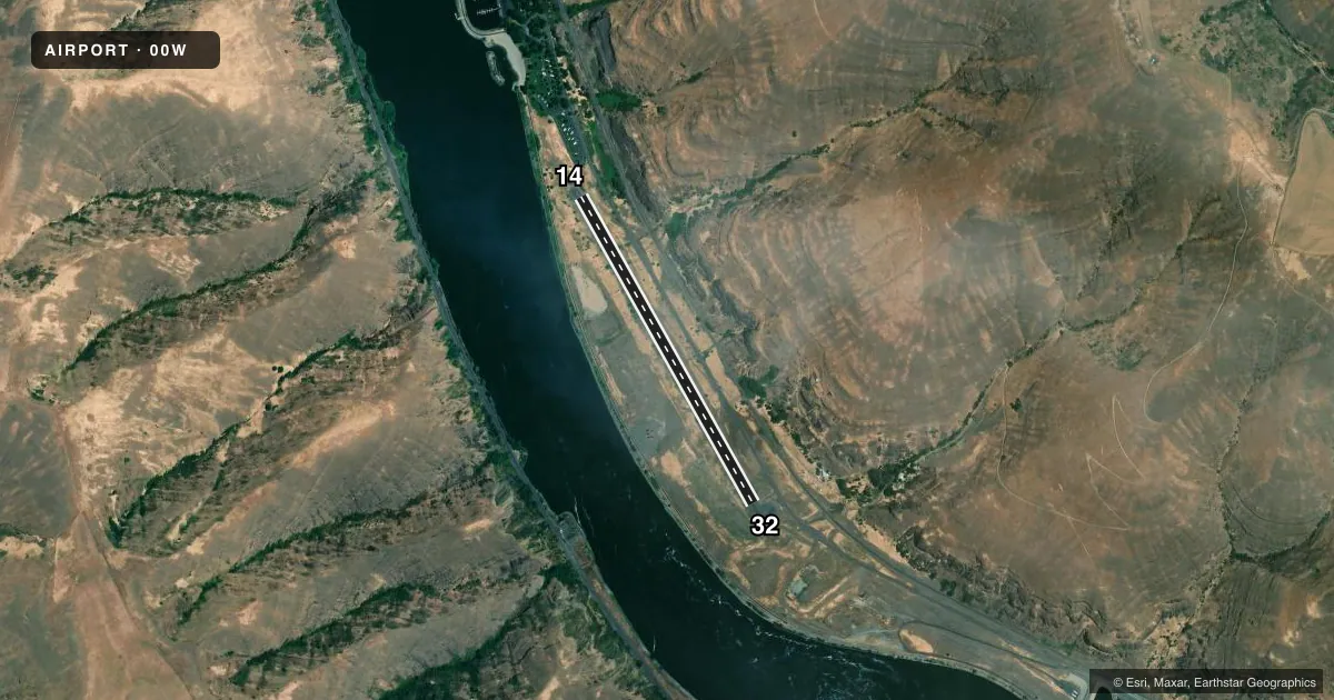
Airport sketch
Runways drawn to scale from FAA survey coordinates, rendered over satellite imagery. Not for navigation.
Approaches & charts
Services on the field
Fuel grades, oxygen, maintenance, ramp storage and lighting — as declared to the FAA by the airport operator.
Fuel & services
- Fuel
- Not available
- Oxygen (bottled)
- Not available
- Oxygen (bulk)
- Not available
- Airframe repair
- Not available
- Power plant repair
- Not available
Ramp & ground
- Transient storage
- Tie-down
- Landing fee
- No fee published
- Wind indicator
- Yes
- Segmented circle
- Yes
Fuel & FBOs
Cheapest 100LL and Jet A on the field and nearby. Always confirm with the FBO before taxi.
Airport notes
Surface conditions, obstructions, local procedures, lighting outages and other notes published with each FAA cycle.
General notes
- VEHICLES; PEDESTRIANS, AND ANIMALS ON & INOV RY.
- STEEP DROP OFF ON BOTH SIDES OF RUNWAY.
- FOR CD CTC SEATTLE ARTCC AT 253-351-3694.
- NO WINTER SNOW REMOVAL OPS.
Approach & departure obstructions
- 14HILL +500'; 8000' FROM THR.
- 32PLINE +1200'; 6000' FROM THR.
Other notes
- PVDD ALL TFC PATS ARE ESTABLISHED ON THE NE SIDE OF THE ARPT DUE TO HIGH TERRAIN TO THE WEST.
- PILOTS PROVD OWN TIEDOWN CHAINS.
- 14/32GRVL PORTIONS OF RY SFC ROUGH AND SOFT.
VFR map & nearby airports
VFR sectional. Tap any ICAO chip to open that airport.
Key facts · 00W
Answer card- ICAO
- 00W
- Name
- LOWER GRANITE STATE
- Location
- COLFAX, WASHINGTON
- Elevation
- 719 ft MSL
- Traffic pattern altitude
- 1,719 ft MSL (1,000 AGL)
- Control tower
- Non-towered (use CTAF)
- Total runways
- 1
- Longest runway
- 14/32 · 3,400 ft
- Published ILS approaches
- 0
- Published frequencies
- 1
- Magnetic variation
- 19°
- Current flight rules
- MVFR
- Current wind
- 000° at 0 kt
- Favored runway now
- –
Lower Granite State Airport (00W) sits near Colfax, Washington. The field elevation is 719 ft MSL. It has one runway. Runway 14/32 is 3,400 ft long and has a gravel surface. The airport is not towered. CTAF is 122.9. No ILS approaches are published here.
Pattern altitude is not published. Use the standard 1,000 ft AGL pattern for light piston operations unless the current Chart Supplement says otherwise. Published remarks say all traffic patterns are on the northeast side of the airport because of high terrain to the west. That matters here. The runway environment also has a steep drop off on both sides. There is a hill about 8,000 ft from the threshold of Runway 14. A power line is about 6,000 ft from the threshold of Runway 32.
There are no on-field FBOs listed. Plan fuel and ground support with the airport operator or the FBO directly by phone before arrival. Published remarks also say the gravel runway surface can be rough and soft in places. There are vehicles, pedestrians and animals in the area. No winter snow removal operations are provided. Pilots must provide their own tiedown chains. For clearance delivery, contact Seattle ARTCC at 253-351-3694.