METAR & TAF 16W
16W does not publish a METAR.
Showing the nearest reporting station: KALW (WALLA WALLA RGNL) · 31.7 NM away. Conditions at 16W may differ.
METAR · KALW
Observed 12:53Z
KALW 271253Z 17003KT 10SM CLR 18/04 A3004 RMK AO2 SLP163 T01780039
- Wind
- 170° @ 3 kt
- Visibility
- 10 SM
- Temp / Dew
- 18°C / 4°C
- Altimeter
- 30.04 inHg
- Clouds
- CLR
- Density alt
- 1,056 ft
- Ceiling
- Unlimited
- Rules
- VFR
Airport info & contacts
Manager on record, flight service, ARTCC, attendance schedule and pattern altitude — published by the FAA and refreshed every 28 days.
Location
- From city
- 7 NM NE
- VFR sectional
- SEATTLE
- ARTCC
- ZSE · SEATTLE
- NOTAM facility
- SEA (NOTAM-D)
Airport manager
- Name
- JOHN WILSON
- Phone
- (360) 618-2477
- Address
- PO BOX 47312, OLYMPIA WA 98504-7264
Flight service · Hours
- FSS SEA
- SEATTLE1-800-WX-BRIEF
- Attendance
- Unattended
Frequencies
Tap any row to copy the frequency to your clipboard.
Runways & pattern
Full pagePattern entry · RWY 07
LEFT TRAFFICRunway end performance
| End | TORA | TODA | ASDA | LDA | VGSI | Approach lights | Obstruction |
|---|---|---|---|---|---|---|---|
| 07 | — | — | — | — | — | — | 12', road, 25' from thr, 0' R of cntrln, slope 2 |
| 25 | — | — | — | — | — | — | 262', hill, 4200' from thr, 420' R of cntrln, slope 16 |
Declared distances in feet. TORA = takeoff run available, TODA = takeoff distance, ASDA = accelerate-stop, LDA = landing distance.
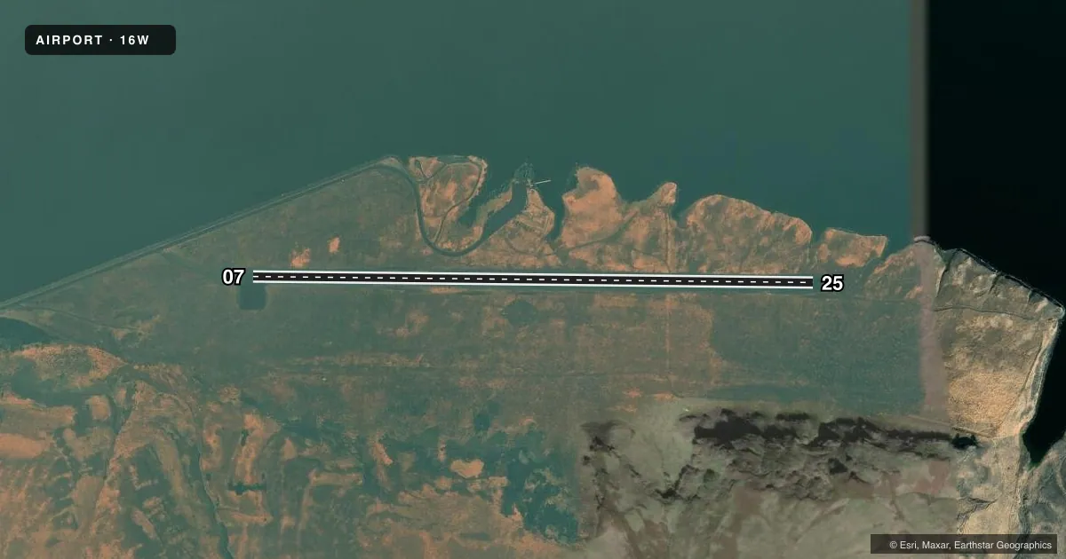
Airport sketch
Runways drawn to scale from FAA survey coordinates, rendered over satellite imagery. Not for navigation.
Approaches & charts
Services on the field
Fuel grades, oxygen, maintenance, ramp storage and lighting — as declared to the FAA by the airport operator.
Fuel & services
- Fuel
- Not available
- Oxygen (bottled)
- Not available
- Oxygen (bulk)
- Not available
- Airframe repair
- Not available
- Power plant repair
- Not available
Ramp & ground
- Transient storage
- Tie-down
- Landing fee
- No fee published
- Wind indicator
- Yes
- Segmented circle
- No
Fuel & FBOs
Cheapest 100LL and Jet A on the field and nearby. Always confirm with the FBO before taxi.
Airport notes
Surface conditions, obstructions, local procedures, lighting outages and other notes published with each FAA cycle.
General notes
- PEDESTRIANS, VEHICLES, AND ANIMALS ON & INVOF RY.
Other notes
- PILOTS PROVD CHAINS.
- 07/25RWY SFC ROUGH AND SOFT.
VFR map & nearby airports
VFR sectional. Tap any ICAO chip to open that airport.
Key facts · 16W
Answer card- ICAO
- 16W
- Name
- LITTLE GOOSE LOCK AND DAM
- Location
- STARBUCK, WASHINGTON
- Elevation
- 681 ft MSL
- Traffic pattern altitude
- 1,681 ft MSL (1,000 AGL)
- Control tower
- Non-towered (use CTAF)
- Total runways
- 1
- Longest runway
- 07/25 · 3,400 ft
- Published ILS approaches
- 0
- Published frequencies
- 1
- Magnetic variation
- 19°
- Current flight rules
- VFR
- Current wind
- 170° at 3 kt
- Favored runway now
- RWY 07
Little Goose Lock and Dam Airport sits near Starbuck, Washington. Field elevation is 681 ft MSL. The airport has one runway. Runway 07/25 is 3,400 ft long and gravel. The published magnetic runway headings are 91° and 271°. No control tower is published. CTAF is 122.9.
No ILS approaches are published here. Pattern altitude is not published. For light piston operations, use the standard 1,000 ft AGL pattern unless the current FAA Chart Supplement says otherwise. That puts the pattern near 1,681 ft MSL based on the field elevation. Check the current FAA Chart Supplement before you go.
There are no on-field FBOs listed. Bring what you need for the stop. The published remarks matter here. Pedestrians, vehicles and animals may be on or near the runway. The surface is rough and soft. Pilots also provide chains. That points to a field where surface condition and ground handling deserve attention on arrival and departure. Plan for a careful taxi. Plan for a conservative takeoff roll. Keep a close look at the runway before you commit.
This is a non-towered field. Use CTAF calls. Keep your scan wide. Verify current conditions with the airport operator if you have any doubt about runway condition or access.