METAR & TAF S95
S95 does not publish a METAR.
Showing the nearest reporting station: KALW (WALLA WALLA RGNL) · 6.2 NM away. Conditions at S95 may differ.
METAR · KALW
Observed 11:53Z
KALW 271153Z AUTO 15005KT 10SM BKN100 18/03 A3003 RMK AO2 SLP160 T01780033 10239 20167 53003
- Wind
- 150° @ 5 kt
- Visibility
- 10 SM
- Temp / Dew
- 18°C / 3°C
- Altimeter
- 30.03 inHg
- Clouds
- BKN
- Density alt
- 1,154 ft
- Ceiling
- 10,000 ft AGL
- Rules
- VFR
Airport info & contacts
Manager on record, flight service, ARTCC, attendance schedule and pattern altitude — published by the FAA and refreshed every 28 days.
Location
- From city
- 1 NM W
- VFR sectional
- SEATTLE
- ARTCC
- ZSE · SEATTLE
- NOTAM facility
- SEA (NOTAM-D)
Airport manager
- Name
- TARRAGON NW LLC
- Phone
- 509-386-0000
- Address
- 5 W. ALDER SUITE 400, WALLA WALLA WA 99362
Flight service · Hours
- FSS SEA
- SEATTLE1-800-WX-BRIEF
- Attendance
- MON-FRI · 0800-1700
Frequencies
Tap any row to copy the frequency to your clipboard.
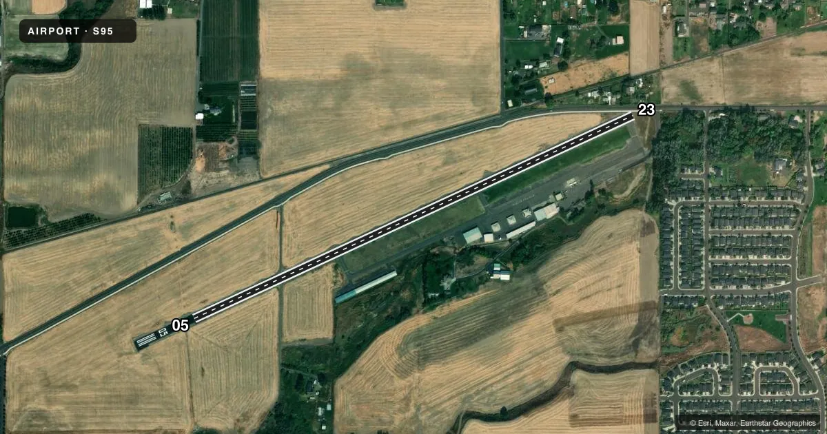
Runways & pattern
Full pagePattern entry · RWY 05
LEFT TRAFFICRunway end performance
| End | TORA | TODA | ASDA | LDA | VGSI | Approach lights | Obstruction |
|---|---|---|---|---|---|---|---|
| 05 | — | — | — | — | VASI 2-box left | — | — |
| 23 | — | — | — | — | VASI 2-box right | — | 15', road, 200' from thr, 0' R of cntrln, slope 0 |
Declared distances in feet. TORA = takeoff run available, TODA = takeoff distance, ASDA = accelerate-stop, LDA = landing distance.
Airport sketch
Runways drawn to scale from FAA survey coordinates, rendered over satellite imagery. Not for navigation.
Approaches & charts
Services on the field
Fuel grades, oxygen, maintenance, ramp storage and lighting — as declared to the FAA by the airport operator.
Fuel & services
- Fuel
- 100LL
- Oxygen (bottled)
- Not available
- Airframe repair
- Minor
- Power plant repair
- Minor
- Other services
- GLD,INSTR,RNTL
Ramp & ground
- Transient storage
- Tie-down
- Landing fee
- No fee published
- Customs
- Not available
- Lighting schedule
- SEE RMK
- Wind indicator
- Yes
- Segmented circle
- No
Fuel & FBOs
Cheapest 100LL and Jet A on the field and nearby. Always confirm with the FBO before taxi.
Airport notes
Surface conditions, obstructions, local procedures, lighting outages and other notes published with each FAA cycle.
General notes
- PRIVATE ROAD CROSSES 700 FT FROM SW END OF RWY.
- GLIDERS AND OTHER AIRCRAFT PERFORM OPERATIONS ON TURF BETWEEN RWY 05/23 AND TAXIWAY.
- FOR CD CTC SPOKANE APCH AT 509-742-2525, WHEN APCH CLSD CTC SEATTLE ARTCC AT 253-351-3694.
Lighting notes
- ACTVT NSTD LIRL RY 05/23 AND VASI RYS 05 AND 23 - CTAF
Fuel notes
- 100LL24 HR SELF SERVICE CREDIT CARD FUELING FACILITY.
Runway surface & condition
- 05/23RY 05/23 NSTD LIRL; SW 1240 FT MED INTST.
Approach & departure obstructions
- 23ROAD 170 FT, ROAD 50 FT R 0, FENCE & MAIL BOX +3 FT; SIDEWALK AND FENCE 32 FT R OF CNTRLN.
Other notes
- OVERNIGHT PARKING FEE OF $3.00.
- PILOTS PROVIDE OWN ROPES.
- 1CALL IN ADVN (509) 386-0000.
- 05/232/3 OF THE RWY HAS WDSPR, OPN, UNSEALED CRACKS & JOINTS, HI LVL OF RAVELING & ALLIGATOR CRACKING.
VFR map & nearby airports
VFR sectional. Tap any ICAO chip to open that airport.
Key facts · S95
Answer card- ICAO
- S95
- Name
- MARTIN FLD
- Location
- COLLEGE PLACE, WASHINGTON
- Elevation
- 750 ft MSL
- Traffic pattern altitude
- 1,750 ft MSL (1,000 AGL)
- Control tower
- Non-towered (use CTAF)
- Total runways
- 1
- Longest runway
- 05/23 · 3,819 ft
- Published ILS approaches
- 0
- Published frequencies
- 2
- Magnetic variation
- 19°
- Current flight rules
- VFR
- Current wind
- 150° at 5 kt
- Favored runway now
- RWY 05
Martin Field (S95) sits in College Place, Washington. The field elevation is 750 ft MSL. It has one asphalt runway, 05/23, which is 3,819 ft long. There is no control tower. CTAF and UNICOM are both 122.8. No ILS approaches are published here, so plan with the current chart and your own equipment if you need precision guidance.
Pattern altitude is not published. Use the standard 1,000 ft AGL pattern unless the current Chart Supplement or local procedures say otherwise. That puts the light piston pattern at about 1,750 ft MSL. Martin Field has one on-field FBO. Martin Field carries 100LL. The field also has 24-hour self-serve credit card fueling. Call ahead at (509) 522-1847 or the airport number in the remarks at 509-386-0000 if you need current ramp details.
The remarks matter here. Gliders and other aircraft use the turf between runway 05/23 and the taxiway. Runway lighting is nonstandard low intensity. The southwest 1,240 ft is medium intensity. There are also runway-end and right-of-centerline obstructions near 23. A road crossing sits farther back from the southwest end. The runway surface has widespread cracking and raveling over much of its length. This is a field where a first-time pilot should brief the pavement, lighting and traffic flow before arrival.