METAR & TAF KHRI
Current METAR
Observed 11:53Z
KHRI 271153Z AUTO 21010KT 10SM CLR 18/07 A3001 RMK AO2 SLP158 T01780067 10233 20172 53007 $
- Wind
- 210° @ 10 kt
- Visibility
- 10 SM
- Temp / Dew
- 18°C / 7°C
- Altimeter
- 30.01 inHg
- Clouds
- CLR
- Density alt
- 1,047 ft
- Ceiling
- Unlimited
- Rules
- VFR
Airport info & contacts
Manager on record, flight service, ARTCC, attendance schedule and pattern altitude — published by the FAA and refreshed every 28 days.
Location
- From city
- 2 NM SE
- VFR sectional
- SEATTLE
- Pattern altitude
- 800 ft AGL · 1,444 ft MSL
- ARTCC
- ZSE · SEATTLE
- NOTAM facility
- HRI (NOTAM-D)
Airport manager
- Name
- LARRY RAWE
- Phone
- 541-567-3694
- Address
- PO BOX 1285, HERMISTON OR 97838
Flight service · Hours
- FSS MMV
- MC MINNVILLE1-800-WX-BRIEF
- Attendance
- OCT-MAR · 0800-1700
- APR-SEP · 0800-1800
Frequencies
Tap any row to copy the frequency to your clipboard.
Runways & pattern
Full pagePattern entry · RWY 23
LEFT TRAFFICRunway end performance
| End | TORA | TODA | ASDA | LDA | VGSI | Approach lights | Obstruction |
|---|---|---|---|---|---|---|---|
| 05 | — | — | — | — | — | — | 41', trees, 800' from thr, 150' R of cntrln, slope 14 |
Declared distances in feet. TORA = takeoff run available, TODA = takeoff distance, ASDA = accelerate-stop, LDA = landing distance.
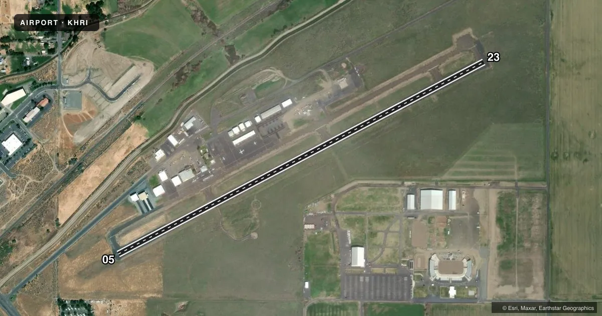
Airport sketch
Runways drawn to scale from FAA survey coordinates, rendered over satellite imagery. Not for navigation.
Approaches & charts
Services on the field
Fuel grades, oxygen, maintenance, ramp storage and lighting — as declared to the FAA by the airport operator.
Fuel & services
- Fuel
- 100LLA+
- Oxygen (bottled)
- Not available
- Oxygen (bulk)
- Not available
- Airframe repair
- Not available
- Power plant repair
- Not available
- Other services
- AGRI,CHTR,INSTR
Ramp & ground
- Transient storage
- Tie-down
- Landing fee
- No fee published
- Customs
- Not available
- Lighting schedule
- SEE RMK
- Beacon schedule
- SS-SR
- Beacon
- White / Green (civil land)(WG)
- Wind indicator
- Lighted
- Segmented circle
- Yes
Fuel & FBOs
Cheapest 100LL and Jet A on the field and nearby. Always confirm with the FBO before taxi.
Airport notes
Surface conditions, obstructions, local procedures, lighting outages and other notes published with each FAA cycle.
General notes
- FOR CD CTC SPOKANE APCH AT 509-742-2525, WHEN APCH CLSD CTC SEATTLE ARTCC AT 253-351-3694.
Lighting notes
- ACTVT REIL RWY 23; MIRL RWY 05/23 - CTAF.
Other notes
- ESTABD PRIOR TO 1959.
VFR map & nearby airports
VFR sectional. Tap any ICAO chip to open that airport.
Key facts · KHRI
Answer card- ICAO
- KHRI
- Name
- HERMISTON MUNI
- Location
- HERMISTON, OREGON
- Elevation
- 644.4 ft MSL
- Traffic pattern altitude
- 1,444.4 ft MSL (800 AGL)
- Control tower
- Non-towered (use CTAF)
- Total runways
- 1
- Longest runway
- 05/23 · 4,501 ft
- Published ILS approaches
- 0
- Published frequencies
- 4
- Magnetic variation
- 14°
- Current flight rules
- VFR
- Current wind
- 210° at 10 kt
- Favored runway now
- RWY 23
Hermiston Muni sits in Hermiston, Oregon. Field elevation is 644.4 ft MSL. The airport has one runway, 05/23, at 4,501 ft. That is the longest runway on the field. There is no control tower. Clearance delivery is handled through Spokane Approach when it is open. When approach is closed, use Seattle ARTCC for clearance help.
Pattern altitude is 800 ft AGL, which is 1,444.4 ft MSL. No ILS approaches are published here, so plan with the current charted procedures before you go. The runway lighting setup is worth a look before a night arrival. Runway 23 has REILs. Runways 05 and 23 have medium intensity runway lights that are activated on CTAF.
Gorge Aviation Services is on the field. It carries 100LL, Jet A and Jet A Prist. The airport uses CTAF 122.8. UNICOM is also 122.8. If you are new to the area, keep the published pattern altitude in mind. Verify the current Chart Supplement for any operational notes before departure. The field has been established since before 1959. Expect a working local airport with standard small-field traffic flow rather than a quiet strip.