METAR & TAF KPDT
Current METAR
Observed 12:53Z
KPDT 271253Z AUTO 15008KT 10SM FU CLR 14/04 A3006 RMK AO2 SLP163 T01440039
- Wind
- 150° @ 8 kt
- Visibility
- 10 SM
- Temp / Dew
- 14°C / 4°C
- Altimeter
- 30.06 inHg
- Clouds
- CLR
- Density alt
- 1,559 ft
- Ceiling
- Unlimited
- Rules
- VFR
Airport info & contacts
Manager on record, flight service, ARTCC, attendance schedule and pattern altitude — published by the FAA and refreshed every 28 days.
Location
- From city
- 3 NM NW
- VFR sectional
- SEATTLE
- ARTCC
- ZSE · SEATTLE
- NOTAM facility
- PDT (NOTAM-D)
Airport manager
- Name
- STEVE CHRISMAN
- Phone
- 541-276-7754
- Address
- 2016 AIRPORT ROAD, PENDLETON OR 97801
Flight service · Hours
- FSS MMV
- MC MINNVILLE1-800-WX-BRIEF
- Attendance
- 0600-2000
Frequencies
Tap any row to copy the frequency to your clipboard.
Runways & pattern
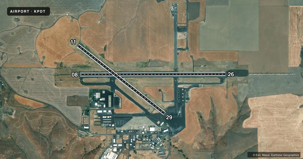
Full pagePattern entry · RWY 11
LEFT TRAFFIC| Runway | Heading (°M) | Length | Surface | Traffic |
|---|---|---|---|---|
| 08/26 | 74° / 254° | 6,301 ft | ASPH | Standard L |
| 11/29Favored | 112° / 292° | 4,808 ft | ASPH | Standard L |
Runway end performance
| End | TORA | TODA | ASDA | LDA | VGSI | Approach lights | Obstruction |
|---|---|---|---|---|---|---|---|
| 08 | 6,301' | 6,301' | 6,301' | 6,301' | VASI 4-box right(3°) | ODALS | 8', gnd, 200' from thr, 500' R of cntrln, slope 0 |
| 26 | 6,301' | 6,301' | 6,301' | 6,301' | PAPI 4-box left(3°) | MALSR | — |
| 11 | 4,808' | 4,808' | 4,808' | 4,808' | PAPI 4-box left(3°) | — | — |
| 29 | 4,808' | 4,808' | 4,808' | 4,808' | PAPI 4-box right(3°) | — | — |
Declared distances in feet. TORA = takeoff run available, TODA = takeoff distance, ASDA = accelerate-stop, LDA = landing distance.
Airport sketch
Runways drawn to scale from FAA survey coordinates, rendered over satellite imagery. Not for navigation.
Approaches & charts
ILS · 1
Services on the field
Fuel grades, oxygen, maintenance, ramp storage and lighting — as declared to the FAA by the airport operator.
Fuel & services
- Fuel
- 100LLA1+MOGAS
- Airframe repair
- Major
- Power plant repair
- Major
- Other services
- AFRT,AGRI,CHTR,INSTR,RNTL,SURV
Ramp & ground
- Transient storage
- Tie-down
- Hangar
- Landing fee
- No fee published
- Customs
- Not available
- Lighting schedule
- SEE RMK
- Beacon schedule
- SS-SR
- Beacon
- White / Green (civil land)(WG)
- Wind indicator
- Lighted
- Segmented circle
- Yes
Fuel & FBOs
Cheapest 100LL and Jet A on the field and nearby. Always confirm with the FBO before taxi.
Airport notes
Surface conditions, obstructions, local procedures, lighting outages and other notes published with each FAA cycle.
General notes
- INT OF RAMP & RWY 29 NORTH END OF TRML BLDG; AREA OBSTD FROM VIEW OF TWR BY TRML BLDG.
- TWY B CLSD SOUTH OF TWY A.
- DEER ON & INVOF ARPT APR AND AUG, ESPECIALLY MORNINGS AND EVENINGS.
- WHEN APCH CLSD, FOR CD CTC SEATTLE ARTCC AT 253-351-3694
- FQT DLY UAS ACTVTY (LGE & SMALL) INSIDE & INVOF THE CDAS.
Lighting notes
- WHEN ATCT CLSD ACTVT MALSR RWY 26; ODALS RWY 08; REIL RWY 11 & 29; VASI RWY 08, PAPI RWY 11; HIRL RWY 08/26; MIRL RWY 11/29 - CTAF. RWY 11/29 PCL FOR HI INTST 5 CLICKS ONLY. PAPI RWY 29 OPR CONSLY.
Runway surface & condition
- 11/29THLD 29 NSTD MRK - PORTION OF RY TO FUNCTION AS TWY.
Approach & departure obstructions
- 11RWY END 11 OUT OF SERVICE.
- 29RWY END 29 OUT OF SERVICE.
Other notes
- ESTABD PRIOR TO 1959 /1934/.
- CLSD TO UNSKED ACR OPN WITH MORE THAN 30 PSGR SEATS EXCP PPR 4 HRS CALL 541-276-4411.
- 1SVCS AVBL FM FBO BTN 2000-0600 BY FONE CALL 541-276-3313/PENDLETON AVN OR 541-310-9542/WILDHORSE HEL. SELF FUELING CARDLOCKS AVBL 24 HRS.
- MANAGER541-966-0243 (ENGINEERING) - WAYNE GREEN
- 08/26SURFACE CONDITION UNMONITORED 1400-0400Z.
- 11/29SURFACE CONDITION UNMONITORED 1400-0400Z.
VFR map & nearby airports
VFR sectional. Tap any ICAO chip to open that airport.
Key facts · KPDT
Answer card- ICAO
- KPDT
- Name
- EASTERN OREGON RGNL AT PENDLETON
- Location
- PENDLETON, OREGON
- Elevation
- 1,494 ft MSL
- Traffic pattern altitude
- 2,494 ft MSL (1,000 AGL)
- Control tower
- Towered · 0600-2000
- Total runways
- 2
- Longest runway
- 08/26 · 6,301 ft
- Published ILS approaches
- 1
- Published frequencies
- 8
- Magnetic variation
- 16°
- Current flight rules
- VFR
- Current wind
- 150° at 8 kt
- Favored runway now
- RWY 11
Eastern Oregon Rgnl at Pendleton sits in Pendleton, Oregon at 1,494 ft MSL. The airport has two asphalt runways. The longest is 08/26 at 6,301 ft. The field is towered from 0600 to 2000. One ILS is published for runway 26. Pattern altitude is not published, so use the standard 1,000 ft AGL for light piston traffic unless ATC or the Chart Supplement says otherwise.
Wildhorse Aviation Fueling is on the field. It carries 100LL, Jet A and Jet A Prist. Call ahead if you need current ramp details or after-hours help. Published remarks also note frequent UAS activity in and near the controlled airspace. Deer have been reported on and near the apron, especially in the morning and evening in August. Taxiway B is closed south of Taxiway A. Runway end 11 and runway end 29 are out of service. Check the current airport status before you plan a landing or departure.
This is a controlled airport with a busy mix of local traffic, instrument arrivals and unmanned aircraft activity. The tower view is partly blocked near the ramp and runway 29 by the terminal building. If you are arriving after tower hours, use CTAF. Review the current Chart Supplement for lighting and any operational notes before you go.