METAR & TAF KRLD
Current METAR
Observed 13:15Z
KRLD 271315Z AUTO 00000KT 10SM OVC060 18/08 A3001 RMK AO2 T01830084
- Wind
- 000° @ 0 kt
- Visibility
- 10 SM
- Temp / Dew
- 18°C / 8°C
- Altimeter
- 30.01 inHg
- Clouds
- OVC
- Density alt
- 737 ft
- Ceiling
- 6,000 ft AGL
- Rules
- VFR
Airport info & contacts
Manager on record, flight service, ARTCC, attendance schedule and pattern altitude — published by the FAA and refreshed every 28 days.
Location
- From city
- 2 NM NW
- VFR sectional
- SEATTLE
- Pattern altitude
- 800 ft AGL · 1,194 ft MSL
- ARTCC
- ZSE · SEATTLE
- NOTAM facility
- SEA (NOTAM-D)
Airport manager
- Name
- QUENTIN WRIGHT
- Phone
- 509-975-6352
- Address
- 3250 PORT OF BENTON BLVD, RICHLAND WA 99354
Flight service · Hours
- FSS SEA
- SEATTLE1-800-WX-BRIEF
- Attendance
- 0800-1800
Frequencies
Tap any row to copy the frequency to your clipboard.
Runways & pattern
Full pagePattern entry · RWY 01
LEFT TRAFFICRunway end performance
| End | TORA | TODA | ASDA | LDA | VGSI | Approach lights | Obstruction |
|---|---|---|---|---|---|---|---|
| 01 | — | — | — | — | PAPI 2-box left(3°) | — | 13', ant, 396' from thr, 258' R of cntrln, slope 15 |
| 19 | — | — | — | — | PAPI 2-box left(3°) | MALS | 24', pole, 795' from thr, 444' R of cntrln, slope 24 |
| 08 | — | — | — | — | PAPI 2-box left(3°) | — | — |
| 26 | — | — | — | — | VASI 4-box left(3°) | — | 16', rr, 573' from thr, 0' R of cntrln, slope 23 |
Declared distances in feet. TORA = takeoff run available, TODA = takeoff distance, ASDA = accelerate-stop, LDA = landing distance.
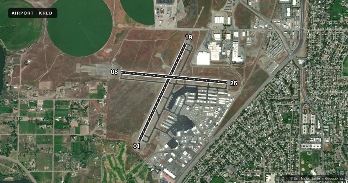
Airport sketch
Runways drawn to scale from FAA survey coordinates, rendered over satellite imagery. Not for navigation.
Approaches & charts
ILS · 1
Services on the field
Fuel grades, oxygen, maintenance, ramp storage and lighting — as declared to the FAA by the airport operator.
Fuel & services
- Fuel
- 100LLA
- Oxygen (bottled)
- Not available
- Oxygen (bulk)
- High pressure
- Airframe repair
- Major
- Power plant repair
- Major
- Other services
- AMB,GLD,INSTR,RNTL
Ramp & ground
- Transient storage
- Tie-down
- Landing fee
- No fee published
- Customs
- Not available
- Lighting schedule
- SEE RMK
- Beacon schedule
- SS-SR
- Beacon
- White / Green (civil land)(WG)
- Wind indicator
- Lighted
- Segmented circle
- Yes
Fuel & FBOs
Cheapest 100LL and Jet A on the field and nearby. Always confirm with the FBO before taxi.
Airport notes
Surface conditions, obstructions, local procedures, lighting outages and other notes published with each FAA cycle.
General notes
- ROAD 550' WEST APCH END RY 08.
- (E94) SAWRS;DRCT PHONE LINE TO FSS.
- PREFERRED RWY 01-19 IN CALM WIND CONDITIONS.
- AIRFIELD CONDS UNMON NGTS, WKENDS AND HOLS.
Lighting notes
- ACTVT MALS RWY 19; REIL RWYS 01 & 19; MIRL RWY 01/19 & 08/26 - CTAF. VASI RWY 26 & PAPI RWYS 01, 08 & 19 OPR 24 HRS.
Fuel notes
- 100LLFUEL BY MAJOR CREDIT CARD - 24 HR AVAILABILITY.
Approach & departure obstructions
- 01CLOSE-IN OBSTN GND.
- 01PAPI UNUSBL BYD 3.0 NM FM THR FOR TRRN ON RIGHT SIDE OF RWY CNTRLN AT APRXLY 3.5 NM.
- 08UNUSBL BYD 8 DEG RIGHT OF CNTRLN.
Other notes
- PILOTS BRING OWN ROPES.
VFR map & nearby airports
VFR sectional. Tap any ICAO chip to open that airport.
Key facts · KRLD
Answer card- ICAO
- KRLD
- Name
- RICHLAND
- Location
- RICHLAND, WASHINGTON
- Elevation
- 394.3 ft MSL
- Traffic pattern altitude
- 1,194.3 ft MSL (800 AGL)
- Control tower
- Non-towered (use CTAF)
- Total runways
- 2
- Longest runway
- 01/19 · 4,009 ft
- Published ILS approaches
- 1
- Published frequencies
- 4
- Magnetic variation
- 17°
- Current flight rules
- VFR
- Current wind
- 000° at 0 kt
- Favored runway now
- –
Richland Airport is in Richland, Washington. Field elevation is 394.3 ft MSL. The airport has two asphalt runways. The longest is runway 01/19 at 4,009 ft. There is no control tower. Pattern altitude is 800 ft AGL, which is 1,194.3 ft MSL.
Runway 19 has the published ILS approach. The field uses CTAF 122.7 and UNICOM 122.7. Spokane Approach and Departure are on 128.75 and 377.2. The on-field FBO is Sundance Aviation. It carries 100LL, Jet A and Jet A Prist. Fuel is available by major credit card with 24-hour availability. That is useful here because the field conditions are unmonitored at night, on weekends and holidays.
A few remarks matter for planning. The preferred runway in calm wind is 01/19. There is a close-in ground obstruction on runway 01. The PAPI on runway 01 is unusable beyond 3.0 NM from the threshold because of terrain on the right side of the centerline farther out. Runway lights are activated via CTAF. The approach lighting system on runway 19 is reported malfunctioning. There is also a road 550 ft west of the approach end of runway 08. First-time pilots should brief the terrain and lighting notes before arrival. Then verify the current Chart Supplement if anything looks different.