METAR & TAF 1S5
Current METAR
Observed 13:35Z
K1S5 271335Z AUTO 04004KT 10SM CLR 13/08 A3002 RMK AO2 T01250076
- Wind
- 040° @ 4 kt
- Visibility
- 10 SM
- Temp / Dew
- 13°C / 8°C
- Altimeter
- 30.02 inHg
- Clouds
- CLR
- Density alt
- 588 ft
- Ceiling
- Unlimited
- Rules
- VFR
Airport info & contacts
Manager on record, flight service, ARTCC, attendance schedule and pattern altitude — published by the FAA and refreshed every 28 days.
Location
- From city
- 2 NM E
- VFR sectional
- SEATTLE
- ARTCC
- ZSE · SEATTLE
- NOTAM facility
- 1S5 (NOTAM-D)
Airport manager
- Name
- HECTOR MEJIA
- Phone
- 509-836-6311
- Address
- 818 EAST EDISON AVENUE, SUNNYSIDE WA 98944
Flight service · Hours
- FSS SEA
- SEATTLE1-800-WX-BRIEF
- Attendance
- Unattended
Frequencies
Tap any row to copy the frequency to your clipboard.
Runways & pattern
Full pagePattern entry · RWY 07
LEFT TRAFFICRunway end performance
| End | TORA | TODA | ASDA | LDA | VGSI | Approach lights | Obstruction |
|---|---|---|---|---|---|---|---|
| 07 | — | — | — | — | — | — | 15', road, 331' from thr, 0' R of cntrln, slope 8 |
| 25 | — | — | — | — | — | — | 46', pole, 1437' from thr, 21' R of cntrln, slope 26 |
Declared distances in feet. TORA = takeoff run available, TODA = takeoff distance, ASDA = accelerate-stop, LDA = landing distance.
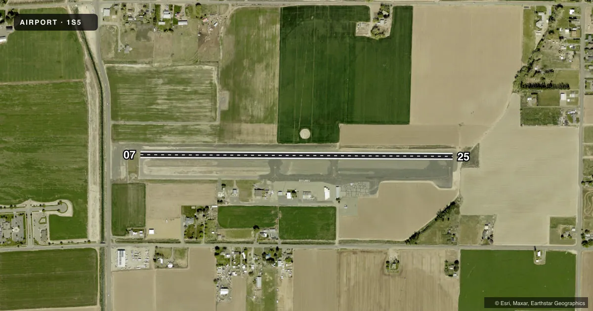
Airport sketch
Runways drawn to scale from FAA survey coordinates, rendered over satellite imagery. Not for navigation.
Approaches & charts
Services on the field
Fuel grades, oxygen, maintenance, ramp storage and lighting — as declared to the FAA by the airport operator.
Fuel & services
- Fuel
- 100LL
- Oxygen (bottled)
- Not available
- Oxygen (bulk)
- Not available
- Other services
- AGRI
Ramp & ground
- Transient storage
- Tie-down
- Landing fee
- No fee published
- Customs
- Not available
- Beacon schedule
- SS-SR
- Beacon
- White / Green (civil land)(WG)
- Wind indicator
- Lighted
- Segmented circle
- Yes
Fuel & FBOs
Cheapest 100LL and Jet A on the field and nearby. Always confirm with the FBO before taxi.
Airport notes
Surface conditions, obstructions, local procedures, lighting outages and other notes published with each FAA cycle.
General notes
- ALL ARPT PROPERTY IS USED FOR AGRI PURPOSES WI 20' OF RY.
- RETRO-REFLECTIVE DEVICES ALONG TWYS.
- FOR CD CTC SPOKANE APCH AT 509-742-2525, WHEN APCH CLSD CTC SEATTLE ARTCC AT 253-351-3694.
- MIGRATORY GEESE.
Approach & departure obstructions
- 25RWY 25 ACES RD 80 FT FM END OF RWY.
Other notes
- ESTABD PRIOR TO 15 MAY 1959.
- PILOTS BRING OWN ROPES.
VFR map & nearby airports
VFR sectional. Tap any ICAO chip to open that airport.
Key facts · 1S5
Answer card- ICAO
- 1S5
- Name
- SUNNYSIDE MUNI
- Location
- SUNNYSIDE, WASHINGTON
- Elevation
- 768 ft MSL
- Traffic pattern altitude
- 1,768 ft MSL (1,000 AGL)
- Control tower
- Non-towered (use CTAF)
- Total runways
- 1
- Longest runway
- 07/25 · 3,425 ft
- Published ILS approaches
- 0
- Published frequencies
- 1
- Magnetic variation
- 19°
- Current flight rules
- VFR
- Current wind
- 040° at 4 kt
- Favored runway now
- RWY 07
Sunnyside Muni is in Sunnyside, Washington. The field elevation is 768 ft MSL. It has one runway. The longest runway is 07/25 at 3,425 ft on asphalt. There is no control tower. CTAF is 122.9. No ILS approaches are published here.
Pattern altitude is not published. Use the standard 1,000 ft AGL pattern unless the current Chart Supplement says otherwise. The airport sits in agricultural country. Expect geese in the area. Taxiways have retro-reflective devices. That helps at night, but it does not replace a careful taxi brief. Runway 25 has ACES Road about 80 ft from the departure end, so pay close attention on takeoff and landing.
Sunnyside Municipal Airport is the on-field FBO. It carries AVGAS 100LL. Pilots must bring their own ropes. For clearance delivery, contact Spokane Approach at 509-742-2525. When approach is closed, contact Seattle ARTCC at 253-351-3694. If you are planning a first visit, verify current procedures in the FAA Chart Supplement before you go. That is the best place to confirm any local operating notes, especially if you are arriving at night or in busy traffic.