METAR & TAF M94
M94 does not publish a METAR.
Showing the nearest reporting station: KYKM (YAKIMA AIR TRML/MCALLISTER FLD) · 26.7 NM away. Conditions at M94 may differ.
METAR · KYKM
Observed 10:53Z
KYKM 271053Z AUTO 00000KT 10SM CLR 13/09 A3000 RMK AO2 SLP152 T01330089 $
- Wind
- 000° @ 0 kt
- Visibility
- 10 SM
- Temp / Dew
- 13°C / 9°C
- Altimeter
- 30.00 inHg
- Clouds
- CLR
- Density alt
- 387 ft
- Ceiling
- Unlimited
- Rules
- VFR
Airport info & contacts
Manager on record, flight service, ARTCC, attendance schedule and pattern altitude — published by the FAA and refreshed every 28 days.
Location
- From city
- 3 NM SW
- VFR sectional
- SEATTLE
- ARTCC
- ZSE · SEATTLE
- NOTAM facility
- SEA (NOTAM-D)
Airport manager
- Name
- ROBERT TRANTINA
- Phone
- 509-596-2298
- Address
- GRANT COUNTY ARPT DISTRICT #1, 319 AIRPORT WAY, DESERT AIRE WA 99349
Flight service · Hours
- FSS SEA
- SEATTLE1-800-WX-BRIEF
- Attendance
- Unattended
Frequencies
Tap any row to copy the frequency to your clipboard.
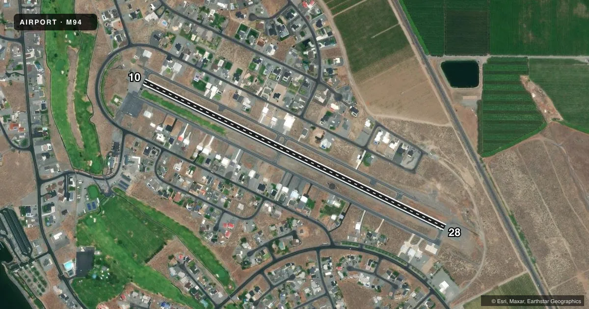
Runways & pattern
Full pagePattern entry · RWY 10
LEFT TRAFFICRunway end performance
| End | TORA | TODA | ASDA | LDA | VGSI | Approach lights | Obstruction |
|---|---|---|---|---|---|---|---|
| 10 | — | — | — | — | — | — | 6', bldg, 270' from thr, 72' R of cntrln, slope 11 |
| 28 | — | — | — | — | PAPI 2-box left(4°) | — | — |
Declared distances in feet. TORA = takeoff run available, TODA = takeoff distance, ASDA = accelerate-stop, LDA = landing distance.
Airport sketch
Runways drawn to scale from FAA survey coordinates, rendered over satellite imagery. Not for navigation.
Approaches & charts
Services on the field
Fuel grades, oxygen, maintenance, ramp storage and lighting — as declared to the FAA by the airport operator.
Fuel & services
- Fuel
- Not available
Ramp & ground
- Transient storage
- Tie-down
- Landing fee
- No fee published
- Lighting schedule
- SEE RMK
- Beacon schedule
- SEE RMK
- Beacon
- White / Green (civil land)(WG)
- Wind indicator
- Lighted
- Segmented circle
- Yes
Fuel & FBOs
Cheapest 100LL and Jet A on the field and nearby. Always confirm with the FBO before taxi.
Airport notes
Surface conditions, obstructions, local procedures, lighting outages and other notes published with each FAA cycle.
General notes
- TWY MKD WITH RETRO-REFLECTIVE DEVICES.
- NO TGL PRIOR TO 0800.
- TRANSIENT PARKING LOCATED ON SE AND SW END OF ARPT.
- EMS HELICOPTER PARKING AREA ON SW END OF ARPT.
- LONG FINAL AND EXTENDED BASE APPROACHES TO RY 28 NOT ADVISED DUE TO CLOSE PROXIMITY OF LOW FLYING FAST MILITARY JETS.
- PAVEMENT RATED FOR 18,000 LBS AIRCRAFT.
- FOR CD CTC SPOKANE APCH AT 509-742-2525, WHEN APCH CLSD CTC SEATTLE ARTCC AT 253-351-3694.
- LCL WX ADZY AVBL - CTAF 3 MIC CLICKS.
Lighting notes
- ACTVT ROTG BCN - CTAF 7 MIC CLICKS.
- ACTVT MIRL RWY 10/28 - CTAF 5 MIC CLICKS.
VFR map & nearby airports
VFR sectional. Tap any ICAO chip to open that airport.
Key facts · M94
Answer card- ICAO
- M94
- Name
- DESERT AIRE RGNL
- Location
- MATTAWA, WASHINGTON
- Elevation
- 586 ft MSL
- Traffic pattern altitude
- 1,586 ft MSL (1,000 AGL)
- Control tower
- Non-towered (use CTAF)
- Total runways
- 1
- Longest runway
- 10/28 · 3,665 ft
- Published ILS approaches
- 0
- Published frequencies
- 2
- Magnetic variation
- 19°
- Current flight rules
- VFR
- Current wind
- 000° at 0 kt
- Favored runway now
- –
Desert Aire Rgnl is in Mattawa, Washington. Field elevation is 586 ft MSL. The airport has one runway. Runway 10/28 is 3,665 ft asphalt, which is the longest runway on the field. There is no control tower. CTAF and UNICOM are both 122.8.
No ILS approaches are published here. Pattern altitude is not published in the facts, so use the standard 1,000 ft AGL for light piston operations unless the current Chart Supplement says otherwise. The published remarks matter here. Clearance delivery goes through Spokane Approach when available. If approach is closed, contact Seattle ARTCC. Runway lights on 10/28 are pilot controlled. The beacon also uses CTAF clicks. There is a local weather advisory on CTAF as well.
Plan for the runway environment before you arrive. Long final and extended base to runway 28 are not advised because of low flying fast military jets nearby. No touch-and-go landings are allowed before 0800. Pavement is rated for 18,000 pounds aircraft. Transient parking is on the southeast and southwest ends of the airport. There are no on-field FBOs listed, so contact the airport operator directly or call the field on CTAF for current services before you go.