METAR & TAF S40
S40 does not publish a METAR.
Showing the nearest reporting station: KRLD (RICHLAND) · 21.1 NM away. Conditions at S40 may differ.
METAR · KRLD
Observed 07:35Z
KRLD 270735Z AUTO 21008KT 10SM OVC070 24/04 A2996 RMK AO2 T02400037
- Wind
- 210° @ 8 kt
- Visibility
- 10 SM
- Temp / Dew
- 24°C / 4°C
- Altimeter
- 29.96 inHg
- Clouds
- OVC
- Density alt
- 1,905 ft
- Ceiling
- 7,000 ft AGL
- Rules
- VFR
Airport info & contacts
Manager on record, flight service, ARTCC, attendance schedule and pattern altitude — published by the FAA and refreshed every 28 days.
Location
- From city
- 1 NM NW
- VFR sectional
- SEATTLE
- Pattern altitude
- 800 ft AGL · 1,506 ft MSL
- ARTCC
- ZSE · SEATTLE
- NOTAM facility
- SEA (NOTAM-D)
Airport manager
- Name
- QUENTIN WRIGHT
- Phone
- 509-975-6352
- Address
- 3250 PORT OF BENTON BLVD, RICHLAND WA 99354
Flight service · Hours
- FSS SEA
- SEATTLE1-800-WX-BRIEF
- Attendance
- Unattended
Frequencies
Tap any row to copy the frequency to your clipboard.
Runways & pattern
Full pagePattern entry · RWY 26
RIGHT TRAFFICRunway end performance
| End | TORA | TODA | ASDA | LDA | VGSI | Approach lights | Obstruction |
|---|---|---|---|---|---|---|---|
| 08 | — | — | — | — | — | — | 71', trees, 2075' from thr, 0' R of cntrln, slope 26 |
Declared distances in feet. TORA = takeoff run available, TODA = takeoff distance, ASDA = accelerate-stop, LDA = landing distance.
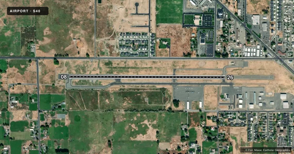
Airport sketch
Runways drawn to scale from FAA survey coordinates, rendered over satellite imagery. Not for navigation.
Approaches & charts
Services on the field
Fuel grades, oxygen, maintenance, ramp storage and lighting — as declared to the FAA by the airport operator.
Fuel & services
- Fuel
- 100LL
- Oxygen (bottled)
- Not available
- Oxygen (bulk)
- Not available
- Airframe repair
- Not available
- Power plant repair
- Not available
- Other services
- INSTR
Ramp & ground
- Transient storage
- Tie-down
- Landing fee
- No fee published
- Customs
- Not available
- Lighting schedule
- SEE RMK
- Beacon schedule
- SS-SR
- Beacon
- White / Green (civil land)(WG)
- Wind indicator
- Lighted
- Segmented circle
- Yes
Fuel & FBOs
Cheapest 100LL and Jet A on the field and nearby. Always confirm with the FBO before taxi.
Airport notes
Surface conditions, obstructions, local procedures, lighting outages and other notes published with each FAA cycle.
General notes
- TWYS MKD FOR NGT OPNS WITH RETRO-REFLECTIVE DEVICES.
- FOR CD CTC SPOKANE APCH AT 509-742-2525, WHEN APCH CLSD CTC SEATTLE ARTCC AT 253-351-3694.
- AIRFIELD CONDS UNMON.
Lighting notes
- ACTVT REIL RWYS 08 & 26; MIRL RWY 08/26 - CTAF.
Other notes
- ESTABD PRIOR TO 15 MAY 1959.
- PILOTS BRING OWN ROPES.
- UNICOM 122.8 0900-1700 ONLY.
VFR map & nearby airports
VFR sectional. Tap any ICAO chip to open that airport.
Key facts · S40
Answer card- ICAO
- S40
- Name
- PROSSER
- Location
- PROSSER, WASHINGTON
- Elevation
- 705.5 ft MSL
- Traffic pattern altitude
- 1,505.5 ft MSL (800 AGL)
- Control tower
- Non-towered (use CTAF)
- Total runways
- 1
- Longest runway
- 08/26 · 3,452 ft
- Published ILS approaches
- 0
- Published frequencies
- 2
- Magnetic variation
- 19°
- Current flight rules
- VFR
- Current wind
- 210° at 8 kt
- Favored runway now
- RWY 26
Prosser Airport sits in Prosser, Washington. The field elevation is 705.5 ft MSL. It has one runway, 08/26, which is 3,452 ft long. There is no control tower. UNICOM 122.8 is listed from 0900 to 1700 only. CTAF is 122.8. No ILS approaches are published here.
Pattern altitude is 800 ft AGL, which is 1,505.5 ft MSL. The runway headings are magnetic 90° and 270°. Prosser Airport is the on-field FBO. It carries 100LL. Bring your own ropes for tie-down. Taxiways are marked for night work with retro-reflective devices. Runway end identifier lights are installed on 08 and 26. Medium intensity runway lights on 08/26 are controlled by CTAF.
For a first-time arrival, the main things to plan for are the non-towered setup and the unmonitored field conditions. Clearance delivery is handled through Spokane Approach at 509-742-2525. When approach is closed, use Seattle ARTCC at 253-351-3694. Check the current FAA Chart Supplement for any changes before you go. The airport is in Prosser, so expect a smaller field environment with one paved runway and standard self-announce traffic flow.