METAR & TAF M50
M50 does not publish a METAR.
Showing the nearest reporting station: KHRI (HERMISTON MUNI) · 23.5 NM away. Conditions at M50 may differ.
METAR · KHRI
Observed 12:53Z
KHRI 271253Z AUTO 21007KT 10SM CLR 17/07 A3002 RMK AO2 SLP160 T01720072 $
- Wind
- 210° @ 7 kt
- Visibility
- 10 SM
- Temp / Dew
- 17°C / 7°C
- Altimeter
- 30.02 inHg
- Clouds
- CLR
- Density alt
- 606 ft
- Ceiling
- Unlimited
- Rules
- VFR
Airport info & contacts
Manager on record, flight service, ARTCC, attendance schedule and pattern altitude — published by the FAA and refreshed every 28 days.
Location
- From city
- 4 NM SW
- VFR sectional
- SEATTLE
- ARTCC
- ZSE · SEATTLE
- NOTAM facility
- MMV (NOTAM-D)
Airport manager
- Name
- LISA MITTELSDORF
- Phone
- 541-481-7678
- Address
- PORT OF MORROW BOX 200, BOARDMAN OR 97818
Flight service · Hours
- FSS MMV
- MC MINNVILLE1-800-WX-BRIEF
- Attendance
- Unattended
Frequencies
Tap any row to copy the frequency to your clipboard.
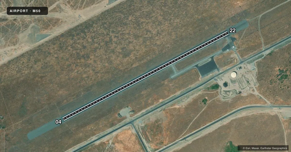
Runways & pattern
Full pagePattern entry · RWY 22
RIGHT TRAFFICAirport sketch
Runways drawn to scale from FAA survey coordinates, rendered over satellite imagery. Not for navigation.
Approaches & charts
Services on the field
Fuel grades, oxygen, maintenance, ramp storage and lighting — as declared to the FAA by the airport operator.
Fuel & services
- Fuel
- Not available
- Airframe repair
- Not available
- Power plant repair
- Not available
Ramp & ground
- Transient storage
- Tie-down
- Landing fee
- No fee published
- Lighting schedule
- SEE RMK
- Beacon schedule
- SS-SR
- Beacon
- White / Green (civil land)(WG)
- Wind indicator
- Lighted
- Segmented circle
- Yes
Fuel & FBOs
Cheapest 100LL and Jet A on the field and nearby. Always confirm with the FBO before taxi.
Airport notes
Surface conditions, obstructions, local procedures, lighting outages and other notes published with each FAA cycle.
General notes
- TELEPHONE AVBL.
- TRIPLE PLINE RUNS EAST-WEST 3000 FT N OF ARPT.
- TAXIWAY EDGE MARKED WITH BLUE REFLECTORS.
- FOR CD CTC SEATTLE ARTCC AT 253-351-3694.
Lighting notes
- ACTVT MIRL RY 04/22 - 122.900.
Approach & departure obstructions
- 04RWY CNTRLN IN POOR COND DUE TO FADING.
- 22RWY CNTRLN IN POOR COND DUE TO FADING.
Other notes
- THIS AIRPORT HAS BEEN SURVEYED BY THE NATIONAL GEODETIC SURVEY.
- MARKED WITH WHITE TIRES.
VFR map & nearby airports
VFR sectional. Tap any ICAO chip to open that airport.
Key facts · M50
Answer card- ICAO
- M50
- Name
- BOARDMAN
- Location
- BOARDMAN, OREGON
- Elevation
- 395.5 ft MSL
- Traffic pattern altitude
- 1,395.5 ft MSL (1,000 AGL)
- Control tower
- Non-towered (use CTAF)
- Total runways
- 1
- Longest runway
- 04/22 · 4,200 ft
- Published ILS approaches
- 0
- Published frequencies
- 1
- Magnetic variation
- 19°
- Current flight rules
- VFR
- Current wind
- 210° at 7 kt
- Favored runway now
- RWY 22
Boardman Airport (M50) sits in Boardman, Oregon at 395.5 ft MSL. It has one runway, 04/22, which is 4,200 ft long and asphalt. The field is not towered. CTAF is 122.9. No ILS approaches are published here.
The published pattern altitude is not listed, so use the standard 1,000 ft AGL pattern unless the current Chart Supplement says otherwise. For this field that works out to about 1,395.5 ft MSL based on the listed elevation. Runway 04/22 has medium intensity lights that are activated on 122.900. The runway centerline is reported in poor condition from fading on both ends. Taxiway edge marking uses blue reflectors.
There are no on-field FBOs listed in the facts, so plan ahead for services and call the airport operator or the field directly before arrival. The remarks also note a segmented circle marked with white tires. Clearance delivery is handled through Seattle ARTCC at 253-351-3694. A triple pipeline runs east-west about 3,000 ft north of the airport, so keep that in mind when you are scanning the area on departure or in the pattern.