METAR & TAF 3S9
3S9 does not publish a METAR.
Showing the nearest reporting station: KDLS (COLUMBIA GORGE RGNL/THE DALLES MUNI) · 47.8 NM away. Conditions at 3S9 may differ.
METAR · KDLS
Observed 12:53Z
KDLS 271253Z AUTO 23004KT 10SM CLR 16/09 A3003 RMK AO2 SLP169 T01560094
- Wind
- 230° @ 4 kt
- Visibility
- 10 SM
- Temp / Dew
- 16°C / 9°C
- Altimeter
- 30.03 inHg
- Clouds
- CLR
- Density alt
- 3,593 ft
- Ceiling
- Unlimited
- Rules
- VFR
Airport info & contacts
Manager on record, flight service, ARTCC, attendance schedule and pattern altitude — published by the FAA and refreshed every 28 days.
Location
- From city
- 1 NM NE
- VFR sectional
- SEATTLE
- ARTCC
- ZSE · SEATTLE
- NOTAM facility
- MMV (NOTAM-D)
Airport manager
- Name
- STATE AIRPORT MANAGER
- Phone
- 503-378-4880
- Address
- 3040 25TH ST SE, SALEM OR 97302-1125
Flight service · Hours
- FSS MMV
- MC MINNVILLE1-800-WX-BRIEF
- Attendance
- Unattended
Frequencies
Tap any row to copy the frequency to your clipboard.
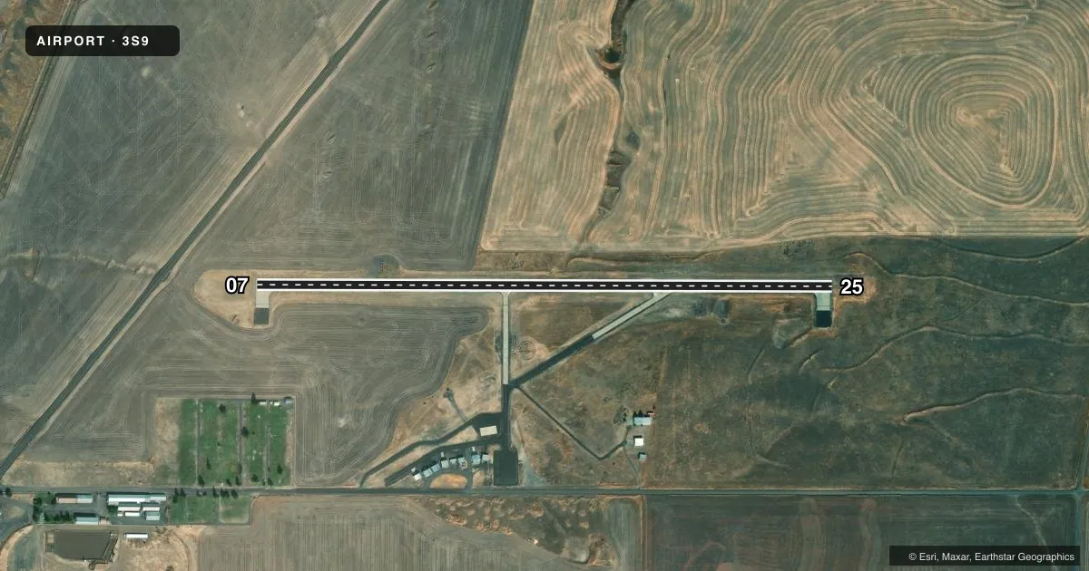
Runways & pattern
Full pagePattern entry · RWY 25
LEFT TRAFFICRunway end performance
| End | TORA | TODA | ASDA | LDA | VGSI | Approach lights | Obstruction |
|---|---|---|---|---|---|---|---|
| 07 | — | — | — | — | PAPI 4-box left(3°) | — | 15', road, 500' from thr, 130' R of cntrln, slope 20 |
| 25 | — | — | — | — | PAPI 4-box left(3°) | — | — |
Declared distances in feet. TORA = takeoff run available, TODA = takeoff distance, ASDA = accelerate-stop, LDA = landing distance.
Airport sketch
Runways drawn to scale from FAA survey coordinates, rendered over satellite imagery. Not for navigation.
Approaches & charts
Services on the field
Fuel grades, oxygen, maintenance, ramp storage and lighting — as declared to the FAA by the airport operator.
Fuel & services
- Fuel
- Not available
- Oxygen (bottled)
- Not available
- Oxygen (bulk)
- Not available
- Airframe repair
- Not available
- Power plant repair
- Not available
- Other services
- AGRI
Ramp & ground
- Transient storage
- Tie-down
- Landing fee
- No fee published
- Customs
- Not available
- Lighting schedule
- SEE RMK
- Beacon schedule
- SS-SR
- Beacon
- White / Green (civil land)(WG)
- Wind indicator
- Lighted
- Segmented circle
- Yes
Fuel & FBOs
Cheapest 100LL and Jet A on the field and nearby. Always confirm with the FBO before taxi.
Airport notes
Surface conditions, obstructions, local procedures, lighting outages and other notes published with each FAA cycle.
General notes
- HEAVY AGRICULTURAL OPNS FEB THRU JUN.
- SURFACE CONDITIONS NOT REPORTED.
- FOR CD CTC SEATTLE ARTCC AT 253-351-3694.
Lighting notes
- ACTVT REIL RWY 07 & 25; MIRL RWY 07/25; PAPI RWY 07 & 25 - CTAF.
Other notes
- ARPT ESTABD PRIOR TO 1959.
VFR map & nearby airports
VFR sectional. Tap any ICAO chip to open that airport.
Key facts · 3S9
Answer card- ICAO
- 3S9
- Name
- CONDON STATE PAULING FLD
- Location
- CONDON, OREGON
- Elevation
- 2,911 ft MSL
- Traffic pattern altitude
- 3,911 ft MSL (1,000 AGL)
- Control tower
- Non-towered (use CTAF)
- Total runways
- 1
- Longest runway
- 07/25 · 3,500 ft
- Published ILS approaches
- 0
- Published frequencies
- 1
- Magnetic variation
- 19°
- Current flight rules
- VFR
- Current wind
- 230° at 4 kt
- Favored runway now
- RWY 25
Condon State Pauling Fld (3S9) sits in Condon, Oregon. The field elevation is 2,911 ft MSL. It has one runway. Runway 07/25 is 3,500 ft long with concrete pavement. The airport is unattended with no control tower. CTAF is 122.9.
No ILS approaches are published here. Pattern altitude is not published in the facts, so use the standard 1,000 ft AGL for light piston traffic unless the current FAA Chart Supplement says otherwise. The published remarks note REIL lighting on Runways 07 and 25. They also note medium intensity runway lighting on 07/25. PAPI is available on CTAF for both ends. Surface conditions are not reported, so plan to verify the runway and taxi surface before you go.
This is a higher-elevation field, so density altitude will matter on warm days. Heavy agricultural operations occur from February through June. Expect that to affect traffic flow and lookout duties in the pattern. For clearance delivery, contact Seattle ARTCC at 253-351-3694. If you need current operational details, check the current FAA Chart Supplement or call the airport operator directly before departure.