METAR & TAF 12S
12S does not publish a METAR.
Showing the nearest reporting station: KGCD (GRANT COUNTY RGNL/OGILVIE FLD) · 32.4 NM away. Conditions at 12S may differ.
METAR · KGCD
Observed 20:35Z
KGCD 262035Z AUTO 00000KT 10SM SCT050 SCT060 SCT095 17/09 A2983 RMK AO2 T01670093
- Wind
- 000° @ 0 kt
- Visibility
- 10 SM
- Temp / Dew
- 17°C / 9°C
- Altimeter
- 29.83 inHg
- Clouds
- SCT
- Density alt
- 3,232 ft
- Ceiling
- Unlimited
- Rules
- VFR
Airport info & contacts
Manager on record, flight service, ARTCC, attendance schedule and pattern altitude — published by the FAA and refreshed every 28 days.
Location
- From city
- 1 NM NW
- VFR sectional
- SEATTLE
- ARTCC
- ZSE · SEATTLE
- NOTAM facility
- MMV (NOTAM-D)
Airport manager
- Name
- DOROTHY JORDAN
- Phone
- 541-934-2025
- Address
- PO BOX 426, MONUMENT OR 97864
Flight service · Hours
- FSS MMV
- MC MINNVILLE1-800-WX-BRIEF
- Attendance
- Unattended
Frequencies
Tap any row to copy the frequency to your clipboard.
Runways & pattern
Full pagePattern entry · RWY 14
LEFT TRAFFICRunway end performance
| End | TORA | TODA | ASDA | LDA | VGSI | Approach lights | Obstruction |
|---|---|---|---|---|---|---|---|
| 14 | — | — | — | — | — | — | 15', hill, 280' from thr, 100' R of cntrln, slope 5 |
Declared distances in feet. TORA = takeoff run available, TODA = takeoff distance, ASDA = accelerate-stop, LDA = landing distance.
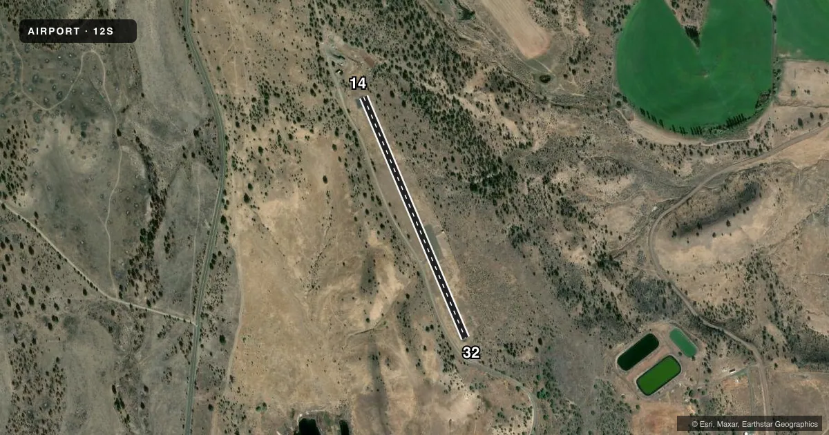
Airport sketch
Runways drawn to scale from FAA survey coordinates, rendered over satellite imagery. Not for navigation.
Approaches & charts
Services on the field
Fuel grades, oxygen, maintenance, ramp storage and lighting — as declared to the FAA by the airport operator.
Fuel & services
- Fuel
- Not available
- Oxygen (bottled)
- Not available
- Oxygen (bulk)
- Not available
- Airframe repair
- Not available
- Power plant repair
- Not available
Ramp & ground
- Transient storage
- Tie-down
- Landing fee
- No fee published
- Wind indicator
- Yes
- Segmented circle
- No
Fuel & FBOs
Cheapest 100LL and Jet A on the field and nearby. Always confirm with the FBO before taxi.
Airport notes
Surface conditions, obstructions, local procedures, lighting outages and other notes published with each FAA cycle.
General notes
- INTMTLY CLSD WINTERS DUE TO SNOW.
- RY 32 TERRAIN SLOPES UP 3.7%.
- HAS +15 FT BY 25 FT CONCRETE PAD AT NORTH END RY 14/32.
- WILDLIFE ON AND INVOF ARPT.
- FOR CD CTC SEATTLE ARTCC AT 253-351-3694.
Approach & departure obstructions
- 14RW 14- 12' TREE AT 96' FROM RUNWAY END AND 15' RIGHT OF CENTERLINE RW 14- 4' FENCE AT 96' FROM RUNWAY END BOTH SIDES OF CENETR LINE
- 327 FT TREES AT 30 FT FM RWY END & 30-50 FT L & R OF CNTRLN.
- 14RY ENDS MKD AT EACH CORNER BY A SINGLE WHITE TIRE.
Other notes
- ESTABD PRIOR TO 15 MAY 1959.
- TIRES PAINTED WHITE.
- FREQ 122.900
VFR map & nearby airports
VFR sectional. Tap any ICAO chip to open that airport.
Key facts · 12S
Answer card- ICAO
- 12S
- Name
- MONUMENT MUNI
- Location
- MONUMENT, OREGON
- Elevation
- 2,323 ft MSL
- Traffic pattern altitude
- 3,323 ft MSL (1,000 AGL)
- Control tower
- Non-towered (use CTAF)
- Total runways
- 1
- Longest runway
- 14/32 · 2,104 ft
- Published ILS approaches
- 0
- Published frequencies
- 1
- Magnetic variation
- 18°
- Current flight rules
- VFR
- Current wind
- 000° at 0 kt
- Favored runway now
- –
Monument Muni sits in Monument, Oregon at 2,323 ft MSL. It has one runway. Runway 14/32 is 2,104 ft long and asphalt. There is no control tower. CTAF and UNICOM are both 122.9. No ILS approaches are published here.
The pattern altitude is not published. Use the standard 1,000 ft AGL for light piston operations unless the current FAA Chart Supplement says otherwise. That puts the normal pattern reference at 3,323 ft MSL based on the field elevation. The airport is in a higher-elevation part of eastern Oregon, so performance planning matters. Winter access can also be an issue because the field is intermittently closed due to snow.
There are no on-field FBOs listed, so plan on confirming fuel and services before you go. Published remarks also call out trees near both runway ends. Runway 32 has seven-foot trees close to the threshold area. Runway 14 has a tree and a fence near the end. Runway 32 also slopes uphill at 3.7 percent. Wildlife is present on and near the airport. For clearance delivery, Seattle ARTCC is listed in the remarks.