METAR & TAF KGCD
Current METAR
Observed 18:15Z
KGCD 271815Z AUTO 00000KT 7SM CLR 24/06 A3011 RMK AO2 T02430056
- Wind
- 000° @ 0 kt
- Visibility
- 7 SM
- Temp / Dew
- 24°C / 6°C
- Altimeter
- 30.11 inHg
- Clouds
- CLR
- Density alt
- 5,436 ft
- Ceiling
- Unlimited
- Rules
- VFR
Airport info & contacts
Manager on record, flight service, ARTCC, attendance schedule and pattern altitude — published by the FAA and refreshed every 28 days.
Location
- From city
- 1 NM SW
- VFR sectional
- KLAMATH FALLS
- ARTCC
- ZSE · SEATTLE
- NOTAM facility
- GCD (NOTAM-D)
Airport manager
- Name
- HALEY WALKER
- Phone
- 541-575-1151
- Address
- 72000 AIRPORT ROAD, JOHN DAY OR 97845
Flight service · Hours
- FSS MMV
- MC MINNVILLE1-800-WX-BRIEF
- Attendance
- OCT-MAY · MON-SAT · 0800-1600
- JUN-SEP · 0700-1900
Frequencies
Tap any row to copy the frequency to your clipboard.
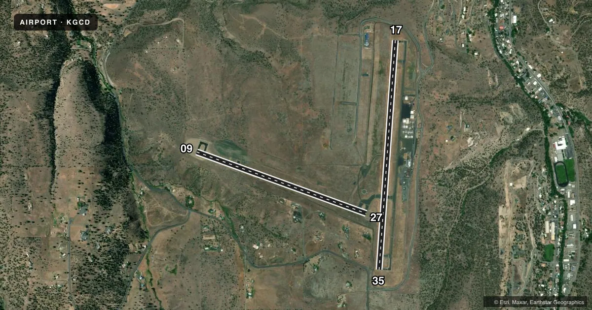
Runways & pattern
Full pagePattern entry · RWY 17
LEFT TRAFFIC| Runway | Heading (°M) | Length | Surface | Traffic |
|---|---|---|---|---|
| 17/35 | 167° / 347° | 5,224 ft | ASPH | Standard L |
| 09/27 | 93° / 273° | 4,100 ft | ASPH | 27 R |
Runway end performance
| End | TORA | TODA | ASDA | LDA | VGSI | Approach lights | Obstruction |
|---|---|---|---|---|---|---|---|
| 17 | — | — | — | — | PAPI 2-box left(3.5°) | — | — |
| 09 | — | — | — | — | PAPI 4-box left(3°) | — | 10', fence, 333' from thr, slope 13 |
Declared distances in feet. TORA = takeoff run available, TODA = takeoff distance, ASDA = accelerate-stop, LDA = landing distance.
Airport sketch
Runways drawn to scale from FAA survey coordinates, rendered over satellite imagery. Not for navigation.
Approaches & charts
Services on the field
Fuel grades, oxygen, maintenance, ramp storage and lighting — as declared to the FAA by the airport operator.
Fuel & services
- Fuel
- 100LLA
Ramp & ground
- Transient storage
- Tie-down
- Lighting schedule
- SEE RMK
- Beacon schedule
- SS-SR
- Beacon
- White / Green (civil land)(WG)
- Wind indicator
- Lighted
- Segmented circle
- Yes
Fuel & FBOs
Cheapest 100LL and Jet A on the field and nearby. Always confirm with the FBO before taxi.
Airport notes
Surface conditions, obstructions, local procedures, lighting outages and other notes published with each FAA cycle.
General notes
- SOFT EDGES ALG RWYS & TWYS. TWYS MKD WITH REFLECTORS.
- 8 FT FENCE ARND ARPT.
- HEL ACT JUL-OCT.
- FOR CD CTC SEATTLE ARTCC AT 253-351-3694.
- AFT HR SELF SVC FUEL AVBL.
Lighting notes
- ACTVT REIL RWY 09 & 17; PAPI RWY 09; MIRL RWY 09/27 & 17/35 - CTAF. PAPI RWY 17 ON CONSLY.
Approach & departure obstructions
- 17PLUS AIMING POINT.
- 35PLUS AIMING POINT.
- 35+850FT TRRN 9400 FT S.
Other notes
- ESTABD PRIOR TO 1959.
VFR map & nearby airports
VFR sectional. Tap any ICAO chip to open that airport.
Key facts · KGCD
Answer card- ICAO
- KGCD
- Name
- GRANT COUNTY RGNL/OGILVIE FLD
- Location
- JOHN DAY, OREGON
- Elevation
- 3,702.5 ft MSL
- Traffic pattern altitude
- 4,702.5 ft MSL (1,000 AGL)
- Control tower
- Non-towered (use CTAF)
- Total runways
- 2
- Longest runway
- 17/35 · 5,224 ft
- Published ILS approaches
- 0
- Published frequencies
- 2
- Magnetic variation
- 17°
- Current flight rules
- VFR
- Current wind
- 000° at 0 kt
- Favored runway now
- –
Grant County Rgnl/Ogilvie Fld sits in John Day, Oregon at 3,702.5 ft MSL. It has two asphalt runways. The longest is 5,224 ft on runway 17/35. There is no control tower. CTAF and UNICOM are both 122.8. No ILS approaches are published here, so plan with the current chart and weather in hand.
Pattern altitude is not published. Use the standard 1,000 ft AGL pattern for light piston aircraft unless local procedures or current guidance say otherwise. The field uses REIL on runways 09 and 17. Runway 09 has PAPI. Runway 17 has PAPI that is on continuously. Both runway pairs have medium intensity runway lighting. That helps for night work, but the airport sits at high elevation. Expect performance to matter on warm days.
Grant County Regional Airport is the on-field FBO. It carries 100LL and Jet A. After hours, self-service fuel is available. The airport also has soft edges along runways and taxiways. Taxiways are marked with reflectors. Helicopter activity occurs from July through October. There is terrain 850 ft AGL about 9,400 ft south of runway 35, so pay attention to departure planning and climb performance. For clearance delivery, contact Seattle ARTCC at 253-351-3694.