METAR & TAF KLGD
Current METAR
Observed 11:56Z
KLGD 271156Z AUTO 34011KT 10SM CLR 14/03 A3008 RMK AO2 SLP169 T01440033 10217 20139 53000 $
- Wind
- 340° @ 11 kt
- Visibility
- 10 SM
- Temp / Dew
- 14°C / 3°C
- Altimeter
- 30.08 inHg
- Clouds
- CLR
- Density alt
- 3,051 ft
- Ceiling
- Unlimited
- Rules
- VFR
Airport info & contacts
Manager on record, flight service, ARTCC, attendance schedule and pattern altitude — published by the FAA and refreshed every 28 days.
Location
- From city
- 4 NM SE
- VFR sectional
- SEATTLE
- ARTCC
- ZSE · SEATTLE
- NOTAM facility
- LGD (NOTAM-D)
Airport manager
- Name
- DOUG WRIGHT
- Phone
- 541-963-6615
- Address
- 60175 PIERCE ROAD, LA GRANDE OR 97850
Flight service · Hours
- FSS MMV
- MC MINNVILLE1-800-WX-BRIEF
- Attendance
- 0800-1700
Frequencies
Tap any row to copy the frequency to your clipboard.
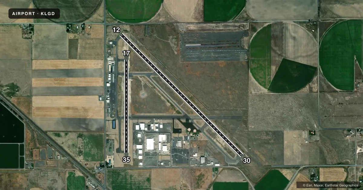
Runways & pattern
Full pagePattern entry · RWY 35
LEFT TRAFFIC| Runway | Heading (°M) | Length | Surface | Traffic |
|---|---|---|---|---|
| 12/30 | 121° / 301° | 6,261 ft | ASPH | Standard L |
| 17/35Favored | 166° / 346° | 3,400 ft | ASPH | Standard L |
Runway end performance
| End | TORA | TODA | ASDA | LDA | VGSI | Approach lights | Obstruction |
|---|---|---|---|---|---|---|---|
| 12 | 6,261' | 6,261' | — | — | PAPI 2-box left(3°) | — | 15', road, 335' from thr, 0' R of cntrln, slope 9 |
| 30 | 6,261' | 6,261' | — | — | PAPI 2-box left(3°) | — | — |
| 17 | — | — | — | — | PAPI 4-box left(3°) | — | — |
Declared distances in feet. TORA = takeoff run available, TODA = takeoff distance, ASDA = accelerate-stop, LDA = landing distance.
Airport sketch
Runways drawn to scale from FAA survey coordinates, rendered over satellite imagery. Not for navigation.
Approaches & charts
Services on the field
Fuel grades, oxygen, maintenance, ramp storage and lighting — as declared to the FAA by the airport operator.
Fuel & services
- Fuel
- 100LLA
- Oxygen (bottled)
- Not available
- Airframe repair
- Major
- Power plant repair
- Major
- Other services
- AGRI,AMB,INSTR
Ramp & ground
- Transient storage
- Tie-down
- Hangar
- Landing fee
- Yes
- Customs
- Not available
- Lighting schedule
- SEE RMK
- Beacon schedule
- SS-SR
- Beacon
- White / Green (civil land)(WG)
- Wind indicator
- Lighted
- Segmented circle
- Yes
Fuel & FBOs
Cheapest 100LL and Jet A on the field and nearby. Always confirm with the FBO before taxi.
Airport notes
Surface conditions, obstructions, local procedures, lighting outages and other notes published with each FAA cycle.
General notes
- EXTSV FOREST SVC OPNS DURG SUMMER MOS.
- FBO & FUELING LCTD WEST OF RWY 17/35
- COLD TEMPERATURE AIRPORT. ALTITUDE CORRECTION REQUIRED AT OR BELOW -16C.
- FOR CD IF UNA TO CTC ON FSS FREQ, CTC SEATTLE ARTCC AT 253-351-3694.
Lighting notes
- ACTVT REIL RWY 17 & 35; PAPI RWY 17; MIRL RWY 12/30 & 17/35 - CTAF.
Approach & departure obstructions
- 12PAPI RWY 12 DOES NOT PRVD OBSTN CLNC BYD 6.0 NM.
- 12RUNWAY 12 OBSTRUCTION CLEARANCE SLOPE 72:1 BASED ON DISPLACED THRESHOLD
Other notes
- ESTABD PRIOR TO 1959.
- OVER 12500 LBS.
- SEGMENTED CIRCLE MARKED IN WHITE ONLY
- CTC IN ADVN FOR HNGR STORAGE.
- 1CLOSED THANKSGIVING, CHRISTMAS AND NEW YEARS.
- 1AFTER HOURS CALL OUT LIST POSTED ON DOOR.
VFR map & nearby airports
VFR sectional. Tap any ICAO chip to open that airport.
Key facts · KLGD
Answer card- ICAO
- KLGD
- Name
- LA GRANDE/UNION COUNTY
- Location
- LA GRANDE, OREGON
- Elevation
- 2,717.6 ft MSL
- Traffic pattern altitude
- 3,717.6 ft MSL (1,000 AGL)
- Control tower
- Non-towered (use CTAF)
- Total runways
- 2
- Longest runway
- 12/30 · 6,261 ft
- Published ILS approaches
- 0
- Published frequencies
- 2
- Magnetic variation
- 14°
- Current flight rules
- VFR
- Current wind
- 340° at 11 kt
- Favored runway now
- RWY 35
La Grande/Union County Airport sits in La Grande, Oregon. The field elevation is 2,717.6 ft MSL. It has two asphalt runways. The longest is runway 12/30 at 6,261 ft. This is an uncontrolled airport. CTAF and UNICOM are both 122.8. No ILS approaches are published here.
Pattern altitude is not published. Use the standard 1,000 ft AGL for light piston traffic unless the current Chart Supplement says otherwise. That puts the normal pattern about 3,717.6 ft MSL. The on-field FBO is La Grande/Union County Airport. It carries 100LL, Jet A and Jet A Prist. The FBO and fueling are west of runway 17/35. After-hours call-out information is posted on the door.
A few items matter for a first arrival. This is a cold temperature airport. Altitude correction is required at or below minus 16 degrees Celsius. Summer brings extensive Forest Service operations. Expect extra traffic. Keep your scan tight. Runway end identifier lights are on runways 17 and 35. PAPI is on runway 17. Medium intensity runway lights are on both runways and are controlled by CTAF. Runway 12 has a published obstruction note. Check the current Chart Supplement before using that end. The airport was established before 1959. It is closed on Thanksgiving, Christmas and New Years.