METAR & TAF 68D
68D does not publish a METAR.
Showing the nearest reporting station: KJSY (JOSEPH STATE) · 15.7 NM away. Conditions at 68D may differ.
METAR · KJSY
Observed 17:15Z
KJSY 271715Z AUTO 11003KT 10SM CLR 24/00 A3014 RMK AO2 T02421005
- Wind
- 110° @ 3 kt
- Visibility
- 10 SM
- Temp / Dew
- 24°C / 0°C
- Altimeter
- 30.14 inHg
- Clouds
- CLR
- Density alt
- 5,287 ft
- Ceiling
- Unlimited
- Rules
- VFR
Airport info & contacts
Manager on record, flight service, ARTCC, attendance schedule and pattern altitude — published by the FAA and refreshed every 28 days.
Location
- From city
- 17 NM SW
- VFR sectional
- SEATTLE
- ARTCC
- ZSE · SEATTLE
- NOTAM facility
- MMV
Airport manager
- Name
- BRANDON CULLEY
- Phone
- 541-963-7171
- Address
- 59973 DOWNS RD, LA GRANDE OR 97850
Flight service · Hours
- FSS MMV
- MC MINNVILLE1-800-WX-BRIEF
- Attendance
- DAWN-DUSK
Frequencies
Tap any row to copy the frequency to your clipboard.
Runways & pattern
Full pagePattern entry · RWY 14
LEFT TRAFFICRunway end performance
| End | TORA | TODA | ASDA | LDA | VGSI | Approach lights | Obstruction |
|---|---|---|---|---|---|---|---|
| 32 | — | — | — | — | — | — | trees |
Declared distances in feet. TORA = takeoff run available, TODA = takeoff distance, ASDA = accelerate-stop, LDA = landing distance.
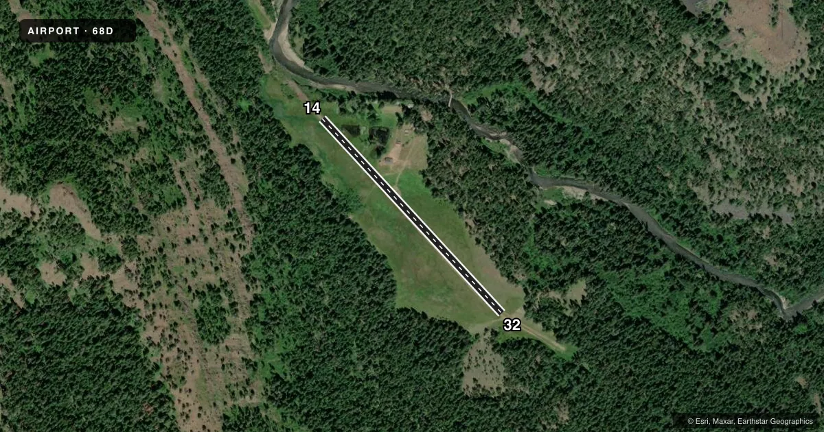
Airport sketch
Runways drawn to scale from FAA survey coordinates, rendered over satellite imagery. Not for navigation.
Approaches & charts
Services on the field
Fuel grades, oxygen, maintenance, ramp storage and lighting — as declared to the FAA by the airport operator.
Fuel & services
- Fuel
- Not available
- Airframe repair
- Not available
- Power plant repair
- Not available
Ramp & ground
- Transient storage
- Not published
- Landing fee
- No fee published
- Wind indicator
- Yes
- Segmented circle
- No
Fuel & FBOs
Cheapest 100LL and Jet A on the field and nearby. Always confirm with the FBO before taxi.
Airport notes
Surface conditions, obstructions, local procedures, lighting outages and other notes published with each FAA cycle.
General notes
- DONT LAND MIDDAY IN HOT WEATHER.
- RWY WET IN SPRING
- CLOSED MIDWINTER SNOW
- CIRCLE TO CHECK RWY FOR OBSTACLES OR OTHER AIRCRAFT BEFORE LANDING.
- FOR CD CTC SEATTLE ARTCC AT 253-351-3694.
- AP DESIRES TO BE CHARTED.
Runway surface & condition
- 14/32700' ADDITIONAL DOGLEG E END.
VFR map & nearby airports
VFR sectional. Tap any ICAO chip to open that airport.
Key facts · 68D
Answer card- ICAO
- 68D
- Name
- REDS HORSE RANCH USFS
- Location
- ENTERPRISE, OREGON
- Elevation
- 3,613 ft MSL
- Traffic pattern altitude
- 4,613 ft MSL (1,000 AGL)
- Control tower
- Non-towered (use CTAF)
- Total runways
- 1
- Longest runway
- 14/32 · 2,125 ft
- Published ILS approaches
- 0
- Published frequencies
- 1
- Magnetic variation
- 18°
- Current flight rules
- VFR
- Current wind
- 110° at 3 kt
- Favored runway now
- RWY 14
REDS HORSE RANCH USFS (68D) sits near Enterprise, Oregon. The field elevation is 3,613 ft MSL. It has one runway, 14/32, which is 2,125 ft of turf. The runway is magnetic, with headings of 137° and 317°. There is no control tower. CTAF is 122.9. No ILS approaches are published.
Pattern altitude is not published. Use the standard 1,000 ft AGL for light piston operations unless the current FAA Chart Supplement says otherwise. The airport is in a high-elevation area, so performance planning matters. The published remarks also call out a few things that deserve attention. Do not land midday in hot weather. The runway can be wet in spring. The airport is closed midwinter due to snow. There is also a 700-foot additional dogleg at the east end of runway 14/32, so brief that geometry before you arrive.
No on-field FBOs are listed. Check the airport operator or the FBO directly by phone for current fuel and service availability before you go. The remarks also say to circle and check the runway for obstacles or other aircraft before landing. For clearance delivery, contact Seattle ARTCC at 253-351-3694.