METAR & TAF O48
O48 does not publish a METAR.
Showing the nearest reporting station: KGIC (IDAHO COUNTY) · 28.6 NM away. Conditions at O48 may differ.
METAR · KGIC
Observed 18:15Z
KGIC 261815Z AUTO 09003KT 10SM CLR 22/08 A3008 RMK AO1
- Wind
- 090° @ 3 kt
- Visibility
- 10 SM
- Temp / Dew
- 22°C / 8°C
- Altimeter
- 30.08 inHg
- Clouds
- CLR
- Density alt
- 1,816 ft
- Ceiling
- Unlimited
- Rules
- VFR
Airport info & contacts
Manager on record, flight service, ARTCC, attendance schedule and pattern altitude — published by the FAA and refreshed every 28 days.
Location
- From city
- 18 NM ENE
- VFR sectional
- GREAT FALLS
- ARTCC
- ZSE · SEATTLE
- NOTAM facility
- MMV
Airport manager
- Name
- UNITED STATES FOREST SERVICE-WWF
- Phone
- 541-963-7171
- Address
- 59973 DOWNS RD., LAGRANDE OR 97850
Flight service · Hours
- FSS MMV
- MC MINNVILLE1-800-WX-BRIEF
Frequencies
Tap any row to copy the frequency to your clipboard.
Runways & pattern
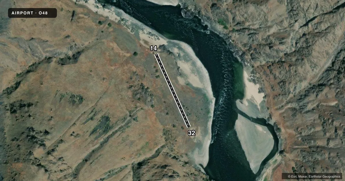
Full pagePattern entry · RWY 14
LEFT TRAFFICAirport sketch
Runways drawn to scale from FAA survey coordinates, rendered over satellite imagery. Not for navigation.
Approaches & charts
Services on the field
Fuel grades, oxygen, maintenance, ramp storage and lighting — as declared to the FAA by the airport operator.
Fuel & services
- Fuel
- Not available
Ramp & ground
- Transient storage
- Not published
Fuel & FBOs
Cheapest 100LL and Jet A on the field and nearby. Always confirm with the FBO before taxi.
Airport notes
Surface conditions, obstructions, local procedures, lighting outages and other notes published with each FAA cycle.
Other notes
- MANAGERBRANDON.CULLEY@USDA.GOV
VFR map & nearby airports
VFR sectional. Tap any ICAO chip to open that airport.
Key facts · O48
Answer card- ICAO
- O48
- Name
- SALMON BAR
- Location
- IMNAHA, OREGON
- Elevation
- 947 ft MSL
- Traffic pattern altitude
- 1,947 ft MSL (1,000 AGL)
- Control tower
- Non-towered (use CTAF)
- Total runways
- 1
- Longest runway
- 14/32 · 762 ft
- Published ILS approaches
- 0
- Published frequencies
- 1
- Magnetic variation
- –
- Current flight rules
- VFR
- Current wind
- 090° at 3 kt
- Favored runway now
- RWY 14
Salmon Bar Airport sits in Imnaha, Oregon. Field elevation is 947 ft MSL. This is a small turf strip with one runway. The longest runway is 14/32 at 762 ft. There is no control tower. CTAF is 122.9.
No ILS approaches are published here. Pattern altitude is not published in the facts, so use standard light aircraft pattern planning unless the current Chart Supplement says otherwise. Runway headings are listed as magnetic in the airport data. The field is short. That matters here more than anything else. Plan for a careful performance check before you go.
There are no on-field FBOs listed. Contact the airport operator directly before arrival if you need current field support. Published remarks list Brandon Culley as the manager contact. The remark gives a USDA email address for that contact. If you need operational details beyond the basics here, verify them in the current Chart Supplement before departure. For a first visit, treat this as a simple, small-airfield arrival. Keep your scan tight. Expect turf operations. Use the published CTAF and make your position reports early.