METAR & TAF 1S7
1S7 does not publish a METAR.
Showing the nearest reporting station: KGIC (IDAHO COUNTY) · 18.0 NM away. Conditions at 1S7 may differ.
METAR · KGIC
Observed 13:15Z
KGIC 271315Z AUTO 00000KT 10SM CLR 12/05 A3011 RMK AO1
- Wind
- 000° @ 0 kt
- Visibility
- 10 SM
- Temp / Dew
- 12°C / 5°C
- Altimeter
- 30.11 inHg
- Clouds
- CLR
- Density alt
- 1,463 ft
- Ceiling
- Unlimited
- Rules
- VFR
Airport info & contacts
Manager on record, flight service, ARTCC, attendance schedule and pattern altitude — published by the FAA and refreshed every 28 days.
Location
- From city
- 3 NM NW
- VFR sectional
- GREAT FALLS
- ARTCC
- ZSE · SEATTLE
- NOTAM facility
- BOI (NOTAM-D)
Airport manager
- Name
- IDAHO DIV OF AERONAUTICS
- Phone
- 208-334-8775
- Address
- PO BOX 7129, BOISE ID 83707-1129
Flight service · Hours
- FSS BOI
- BOISE1-800-WX-BRIEF
- Attendance
- Unattended
Frequencies
Tap any row to copy the frequency to your clipboard.
Runways & pattern
Full pagePattern entry · RWY 12
LEFT TRAFFICRunway end performance
| End | TORA | TODA | ASDA | LDA | VGSI | Approach lights | Obstruction |
|---|---|---|---|---|---|---|---|
| 12 | — | — | — | — | — | — | 35', pline, 0' from thr, 105' R of cntrln, slope 0 |
| 30 | — | — | — | — | — | — | 35', pline, 0' from thr, 100' R of cntrln, slope 1 |
Declared distances in feet. TORA = takeoff run available, TODA = takeoff distance, ASDA = accelerate-stop, LDA = landing distance.
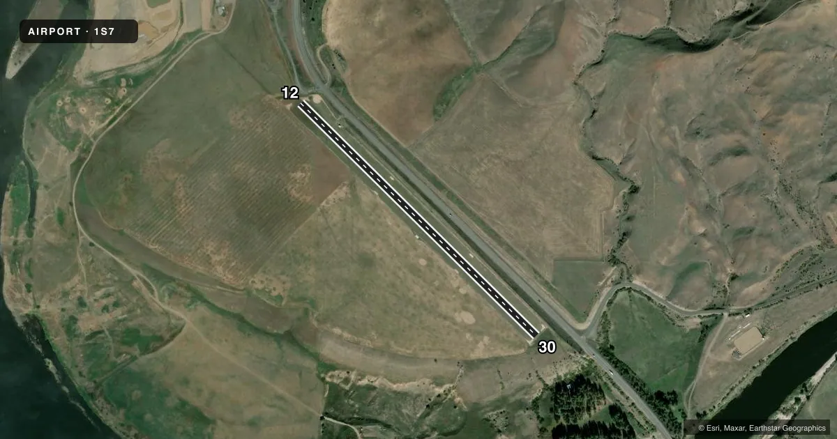
Airport sketch
Runways drawn to scale from FAA survey coordinates, rendered over satellite imagery. Not for navigation.
Approaches & charts
Services on the field
Fuel grades, oxygen, maintenance, ramp storage and lighting — as declared to the FAA by the airport operator.
Fuel & services
- Fuel
- Not available
- Oxygen (bottled)
- Not available
- Oxygen (bulk)
- Not available
- Airframe repair
- Not available
- Power plant repair
- Not available
Ramp & ground
- Transient storage
- Tie-down
- Landing fee
- No fee published
- Customs
- Not available
- Wind indicator
- Yes
- Segmented circle
- Yes
Fuel & FBOs
Cheapest 100LL and Jet A on the field and nearby. Always confirm with the FBO before taxi.
Airport notes
Surface conditions, obstructions, local procedures, lighting outages and other notes published with each FAA cycle.
General notes
- NO LINE OF SIGHT BTN RWY ENDS.
- 35 FT PLINE ALONG NE BNDRY OF ARPT, CROSSES OVER TIEDOWN AREA.
- RWY 12/30 YELLOW & BLACK WARNING PANELS INSTALLED ON FENCE ON BOTH RWY THRS.
- NO WINTER MAINT.
- NO FONE AVBL AT ARPT.
- RWY 12 HAS ADDL OBSTN 35 FT POLE & GUY WIRE AT 10 FT 100 FT L MARKED.
- RWY 12 HAS 3 FT FENCE AT 35 FT ON CNTRLN.
- FOR CD CTC SEATTLE ARTCC AT 253-351-3694.
Approach & departure obstructions
- 12RWY 12 /30 EDGES & THLDS MARKED WITH WHITE ROCK BOUNDARY MARKERS.
- 30+4 FT BARB-WIRE FENCE AT 25 FT ON CNTRLN MARKED.
Other notes
- ESTABD PRIOR TO 12/31/58.
VFR map & nearby airports
VFR sectional. Tap any ICAO chip to open that airport.
Key facts · 1S7
Answer card- ICAO
- 1S7
- Name
- SLATE CREEK
- Location
- SLATE CREEK, IDAHO
- Elevation
- 1,660 ft MSL
- Traffic pattern altitude
- 2,660 ft MSL (1,000 AGL)
- Control tower
- Non-towered (use CTAF)
- Total runways
- 1
- Longest runway
- 12/30 · 2,600 ft
- Published ILS approaches
- 0
- Published frequencies
- 1
- Magnetic variation
- 18°
- Current flight rules
- VFR
- Current wind
- 000° at 0 kt
- Favored runway now
- –
Slate Creek (1S7) sits in Slate Creek, Idaho at 1,660 ft MSL. It has one runway. Runway 12/30 is a 2,600 ft turf strip, so plan for short-field work and soft-field technique. The airport is not towered. CTAF is 122.9. No ILS approaches are published here.
Pattern altitude is not published. Use the standard 1,000 ft AGL pattern unless the current Chart Supplement or local procedures say otherwise. The field has no on-field FBOs listed, so verify fuel and services with the airport operator before you go. Published remarks note no winter maintenance. There is also no telephone at the airport. That matters if you are planning a remote arrival.
Several obstructions are published on the runway. Runway 12 has a fence on the centerline near the threshold. Runway 30 has a barbed-wire fence near the threshold on the centerline. A power line runs along the northeast boundary and crosses over the tiedown area. There is also no line of sight between runway ends. For clearance delivery, contact Seattle ARTCC at 253-351-3694. Check the current FAA Chart Supplement before flying in, especially if you want current obstruction, surface, or operating notes.