METAR & TAF KGIC
Current METAR
Observed 23:35Z
KGIC 262335Z AUTO 02009KT 10SM CLR 28/08 A3002 RMK AO1
- Wind
- 020° @ 9 kt
- Visibility
- 10 SM
- Temp / Dew
- 28°C / 8°C
- Altimeter
- 30.02 inHg
- Clouds
- CLR
- Density alt
- 5,544 ft
- Ceiling
- Unlimited
- Rules
- VFR
Airport info & contacts
Manager on record, flight service, ARTCC, attendance schedule and pattern altitude — published by the FAA and refreshed every 28 days.
Location
- From city
- 1 NM N
- VFR sectional
- GREAT FALLS
- ARTCC
- ZSE · SEATTLE
- NOTAM facility
- BOI (NOTAM-D)
Airport manager
- Name
- MIKE COOK
- Phone
- 208-983-1565
- Address
- 228 AIRPORT LN, GRANGEVILLE ID 83530
Flight service · Hours
- FSS BOI
- BOISE1-800-WX-BRIEF
- Attendance
- Unattended
Frequencies
Tap any row to copy the frequency to your clipboard.
Runways & pattern
Full pagePattern entry · RWY 08
LEFT TRAFFICRunway end performance
| End | TORA | TODA | ASDA | LDA | VGSI | Approach lights | Obstruction |
|---|---|---|---|---|---|---|---|
| 08 | — | — | — | — | — | — | 2', road, 235' from thr, 0' R of cntrln, slope 17 |
Declared distances in feet. TORA = takeoff run available, TODA = takeoff distance, ASDA = accelerate-stop, LDA = landing distance.
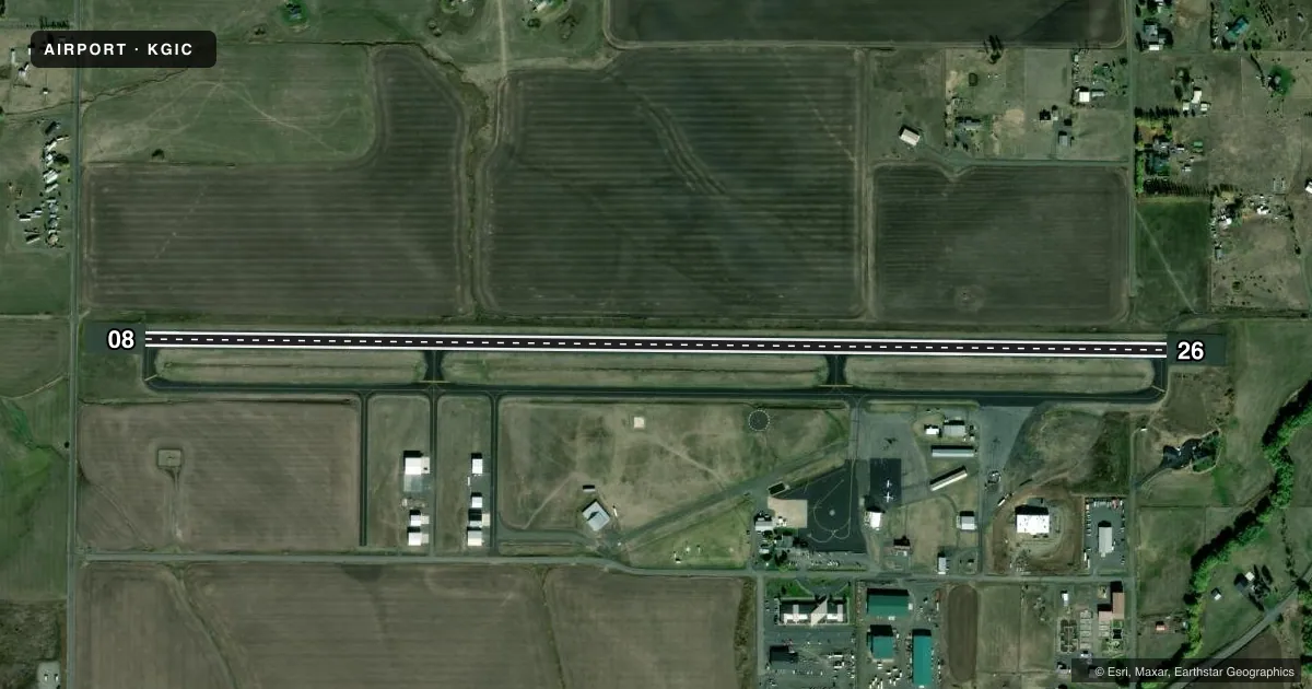
Airport sketch
Runways drawn to scale from FAA survey coordinates, rendered over satellite imagery. Not for navigation.
Approaches & charts
Services on the field
Fuel grades, oxygen, maintenance, ramp storage and lighting — as declared to the FAA by the airport operator.
Fuel & services
- Fuel
- 100LLA
- Oxygen (bottled)
- Not available
- Oxygen (bulk)
- Not available
- Airframe repair
- Minor
- Power plant repair
- Minor
- Other services
- AGRI
Ramp & ground
- Transient storage
- Tie-down
- Landing fee
- No fee published
- Customs
- Not available
- Lighting schedule
- SEE RMK
- Beacon schedule
- SS-SR
- Beacon
- White / Green (civil land)(WG)
- Wind indicator
- Lighted
- Segmented circle
- Yes
Fuel & FBOs
Cheapest 100LL and Jet A on the field and nearby. Always confirm with the FBO before taxi.
Airport notes
Surface conditions, obstructions, local procedures, lighting outages and other notes published with each FAA cycle.
General notes
- CONSIDERABLE USFS FIRE RETARDENT OPERS DURG SUMMER MONTHS.
- PARACHUTE ACTIVITY MAY THRU AUG.
- WILDLIFE IN VCTY.
- BE AWARE MOWING ALL SFCS.
- FOR CD CTC SEATTLE ARTCC AT 253-351-3694.
Lighting notes
- ACTVT REIL RWY 08 & MIRL RWY 08/26 -CTAF.
Fuel notes
- 100LL24 HR SELF SVC CREDIT CARD FUELING FAC.
Other notes
- MANAGERARPT (208) 983-1565; CELL (208) 451-0154
VFR map & nearby airports
VFR sectional. Tap any ICAO chip to open that airport.
Key facts · KGIC
Answer card- ICAO
- KGIC
- Name
- IDAHO COUNTY
- Location
- GRANGEVILLE, IDAHO
- Elevation
- 3,313.1 ft MSL
- Traffic pattern altitude
- 4,313.1 ft MSL (1,000 AGL)
- Control tower
- Non-towered (use CTAF)
- Total runways
- 1
- Longest runway
- 08/26 · 5,101 ft
- Published ILS approaches
- 0
- Published frequencies
- 1
- Magnetic variation
- 14°
- Current flight rules
- VFR
- Current wind
- 020° at 9 kt
- Favored runway now
- RWY 08
Idaho County Airport sits in Grangeville, Idaho. Field elevation is 3,313.1 ft MSL. The airport has one runway. Runway 08/26 is 5,101 ft long. There is no control tower. CTAF is 122.8. No ILS approaches are published here.
Pattern altitude is not published. Use 1,000 ft AGL for light piston traffic unless the current Chart Supplement says otherwise. The on-field FBO is Idaho County Airport. It carries 100LL and Jet A. 24-hour self-service credit card fueling is available for 100LL. The airport manager can be reached at the same published phone number if you need current field status.
Plan for a mountain airport environment. The field sits at a higher elevation, so density altitude can matter a lot in warm weather. Wildlife is present near the airport. Parachute activity may occur through August. Mowing also happens on all surfaces. In summer, considerable Forest Service fire retardant operations occur. Runway end identifier lights are activated on runway 08. Medium intensity runway lights are activated on runways 08 and 26 by CTAF. For clearance delivery, contact Seattle ARTCC before departure if you need IFR handling.