METAR & TAF S89
S89 does not publish a METAR.
Showing the nearest reporting station: KLWS (LEWISTON/NEZ PERCE COUNTY) · 23.5 NM away. Conditions at S89 may differ.
METAR · KLWS
Observed 09:56Z
KLWS 270956Z AUTO 00000KT 6SM HZ CLR 20/06 A3001 RMK AO2 SLP150 T02000056 $
- Wind
- 000° @ 0 kt
- Visibility
- 6 SM
- Temp / Dew
- 20°C / 6°C
- Altimeter
- 30.01 inHg
- Clouds
- CLR
- Density alt
- 5,207 ft
- Ceiling
- Unlimited
- Rules
- VFR
Airport info & contacts
Manager on record, flight service, ARTCC, attendance schedule and pattern altitude — published by the FAA and refreshed every 28 days.
Location
- From city
- 0 NM N
- VFR sectional
- GREAT FALLS
- ARTCC
- ZSE · SEATTLE
- NOTAM facility
- BOI (NOTAM-D)
Airport manager
- Name
- SAM CHRISTIANSEN
- Phone
- 208-400-1309
- Address
- 109 E MAIN ST, CRAIGMONT ID 83523
Flight service · Hours
- FSS BOI
- BOISE1-800-WX-BRIEF
- Attendance
- Unattended
Frequencies
Tap any row to copy the frequency to your clipboard.
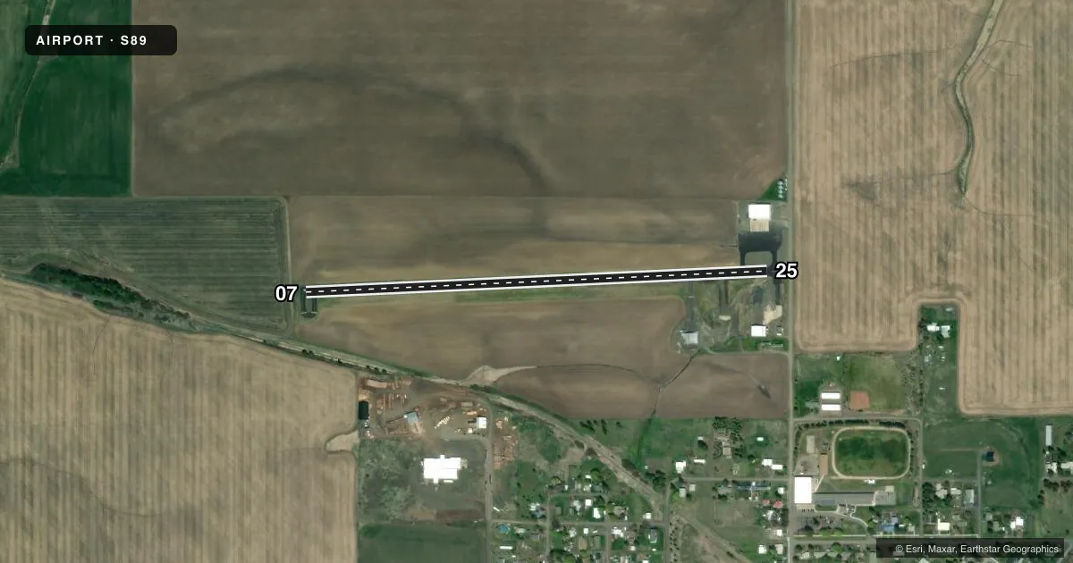
Runways & pattern
Full pagePattern entry · RWY 07
LEFT TRAFFICRunway end performance
| End | TORA | TODA | ASDA | LDA | VGSI | Approach lights | Obstruction |
|---|---|---|---|---|---|---|---|
| 25 | — | — | — | — | — | — | 10', gnd, 275' from thr, 0' R of cntrln, slope 7 |
Declared distances in feet. TORA = takeoff run available, TODA = takeoff distance, ASDA = accelerate-stop, LDA = landing distance.
Airport sketch
Runways drawn to scale from FAA survey coordinates, rendered over satellite imagery. Not for navigation.
Approaches & charts
Services on the field
Fuel grades, oxygen, maintenance, ramp storage and lighting — as declared to the FAA by the airport operator.
Fuel & services
- Fuel
- Not available
- Oxygen (bottled)
- Not available
- Oxygen (bulk)
- Not available
Ramp & ground
- Transient storage
- Tie-down
- Landing fee
- No fee published
- Customs
- Not available
- Lighting schedule
- SEE RMK
- Beacon schedule
- SEE RMK
- Beacon
- White / Green (civil land)(WG)
- Wind indicator
- Yes
- Segmented circle
- No
Fuel & FBOs
Cheapest 100LL and Jet A on the field and nearby. Always confirm with the FBO before taxi.
Airport notes
Surface conditions, obstructions, local procedures, lighting outages and other notes published with each FAA cycle.
General notes
- FOR CD CTC SEATTLE ARTCC AT 253-351-3694.
Lighting notes
- ACTVT BCN-CTAF
- ACTVT MIRL RY 07/25-CTAF
Runway surface & condition
- 07/25RECOMMEND LANDING RY 25; DEPARTING RY 07; WHEN WIND CONDITIONS PERMIT.
Approach & departure obstructions
- 25+16 FT ROAD 35 FT FM RY END ON CNTRLN.
- 25RWY 25 HAS A 300 FT DTHR & IS MKD WITH DTHLD LGTS & RWY MRKGS.
- 25+16 FT ROAD AT 335 FT ON CNTRLN; 20:1 BASED ON DSPLCD THLD.
Other notes
- ESTABD PRIOR TO 5/15/59.
- 1ARPT CLOSED AFTER HEAVY SNOWFALL.
VFR map & nearby airports
VFR sectional. Tap any ICAO chip to open that airport.
Key facts · S89
Answer card- ICAO
- S89
- Name
- CRAIGMONT MUNI
- Location
- CRAIGMONT, IDAHO
- Elevation
- 3,805 ft MSL
- Traffic pattern altitude
- 4,805 ft MSL (1,000 AGL)
- Control tower
- Non-towered (use CTAF)
- Total runways
- 1
- Longest runway
- 07/25 · 2,800 ft
- Published ILS approaches
- 0
- Published frequencies
- 1
- Magnetic variation
- 18°
- Current flight rules
- VFR
- Current wind
- 000° at 0 kt
- Favored runway now
- –
Craigmont Muni sits in Craigmont, Idaho. The field elevation is 3,805 ft MSL. It has one runway, 07/25, which is 2,800 ft long and paved. There is no control tower. CTAF is 122.9.
No ILS approaches are published here. The pattern altitude is not published, so use the standard 1,000 ft AGL for light piston operations unless the current Chart Supplement says otherwise. Runway 25 has a 300-foot displaced threshold. The published remarks also call out a 16-foot road on the centerline near the runway 25 end. That makes the departure and landing picture on 25 worth a close look.
The runway lights on 07/25 are CTAF-activated. The beacon is also CTAF-activated. Published remarks recommend landing runway 25 and departing runway 07 when wind conditions permit. The airport is closed after heavy snowfall. So winter access needs a current check before you launch. No on-field FBOs are listed, so contact the airport operator directly or call the field on CTAF for current fuel and service availability. For clearance delivery, contact Seattle ARTCC at 253-351-3694. This is a high-elevation Idaho field, so performance planning matters. Check density altitude, runway length and the wind before you go.