METAR & TAF I45
I45 does not publish a METAR.
Showing the nearest reporting station: KGIC (IDAHO COUNTY) · 26.7 NM away. Conditions at I45 may differ.
METAR · KGIC
Observed 05:35Z
KGIC 270535Z AUTO 00000KT 7SM CLR 17/06 A3008 RMK AO1
- Wind
- 000° @ 0 kt
- Visibility
- 7 SM
- Temp / Dew
- 17°C / 6°C
- Altimeter
- 30.08 inHg
- Clouds
- CLR
- Density alt
- 1,796 ft
- Ceiling
- Unlimited
- Rules
- VFR
Airport info & contacts
Manager on record, flight service, ARTCC, attendance schedule and pattern altitude — published by the FAA and refreshed every 28 days.
Location
- From city
- 19 NM SSW
- VFR sectional
- GREAT FALLS
- ARTCC
- ZSE · SEATTLE
- NOTAM facility
- BOI
Airport manager
- Name
- DON JENKINS
- Phone
- 208-799-5010
- Address
- 3316 16TH ST, LEWISTON ID 83501
Flight service · Hours
- FSS BOI
- BOISE1-800-WX-BRIEF
Frequencies
Tap any row to copy the frequency to your clipboard.
Runways & pattern
Full pagePattern entry · RWY 15
LEFT TRAFFICRunway end performance
| End | TORA | TODA | ASDA | LDA | VGSI | Approach lights | Obstruction |
|---|---|---|---|---|---|---|---|
| 15 | — | — | — | — | — | — | 10', bldg, 75' from thr, 20' R of cntrln, slope 7 |
| 33 | — | — | — | — | — | — | 25', tree, 25' from thr, 100' R of cntrln, slope 1 |
Declared distances in feet. TORA = takeoff run available, TODA = takeoff distance, ASDA = accelerate-stop, LDA = landing distance.
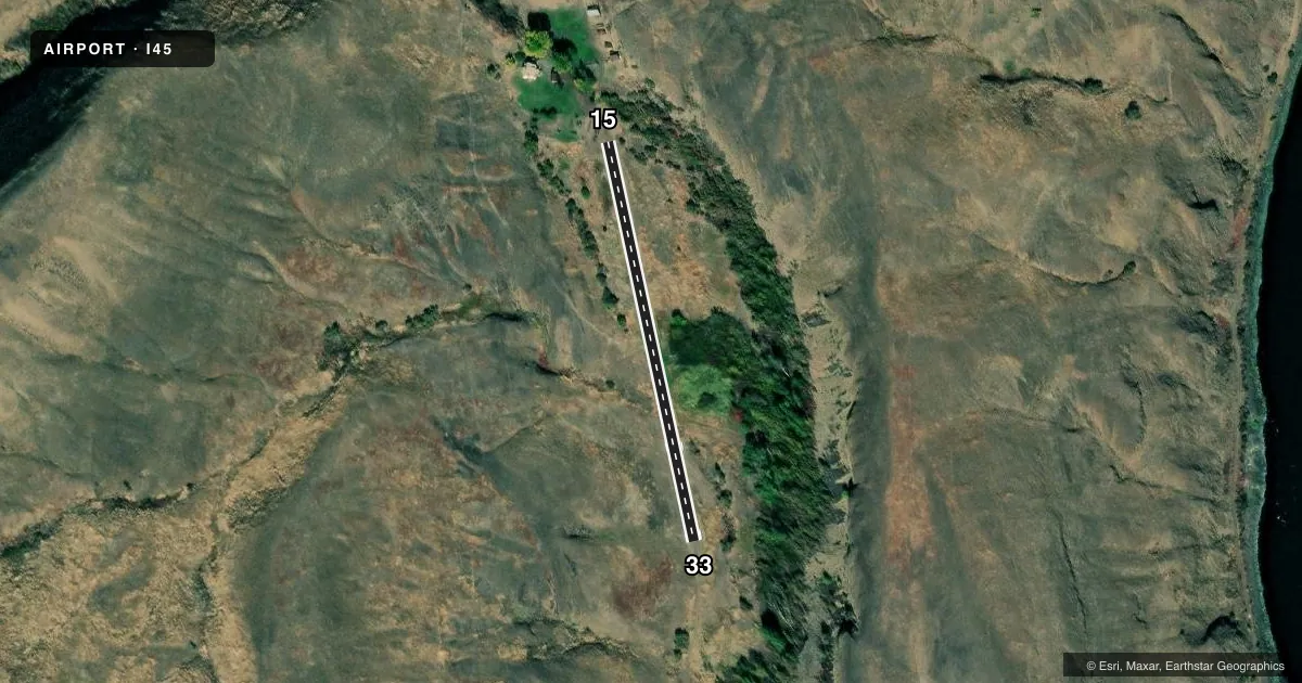
Airport sketch
Runways drawn to scale from FAA survey coordinates, rendered over satellite imagery. Not for navigation.
Approaches & charts
Services on the field
Fuel grades, oxygen, maintenance, ramp storage and lighting — as declared to the FAA by the airport operator.
Fuel & services
- Fuel
- Not available
Ramp & ground
- Transient storage
- Tie-down
- Wind indicator
- Yes
- Segmented circle
- No
Fuel & FBOs
Cheapest 100LL and Jet A on the field and nearby. Always confirm with the FBO before taxi.
Airport notes
Surface conditions, obstructions, local procedures, lighting outages and other notes published with each FAA cycle.
General notes
- ONE WAY AIRSTRIP. LND RWY33 AND TOKF RWY15.
- VERY SHRT RWY W/10 PCT SLP. RWY 33 ELEV 1317 FT & RWY 15 ELEV 1415 FT.
- USE AT OWN RISK.
Other notes
- MANAGERDON.JENKINS@IDFG.IDAHO.GOV
- OWNERID DEPT OF FISH AND GAME - EMAIL: IDFGCOMMISSION@IDFG.IDAHO.GOV
- 15/33FAIR
VFR map & nearby airports
VFR sectional. Tap any ICAO chip to open that airport.
Key facts · I45
Answer card- ICAO
- I45
- Name
- WAPSHILLA
- Location
- WINCHESTER, IDAHO
- Elevation
- 1,415 ft MSL
- Traffic pattern altitude
- 2,415 ft MSL (1,000 AGL)
- Control tower
- Non-towered (use CTAF)
- Total runways
- 1
- Longest runway
- 15/33 · 1,026 ft
- Published ILS approaches
- 0
- Published frequencies
- 1
- Magnetic variation
- –
- Current flight rules
- VFR
- Current wind
- 000° at 0 kt
- Favored runway now
- –
Wapshilla Airport (I45) is in Winchester, Idaho. Field elevation is 1,415 ft MSL. It has one runway. The longest runway is 15/33 at 1,026 ft on turf-dirt. This is a non-towered field. CTAF is 122.9. No ILS approaches are published.
The published pattern altitude is not listed. Use the current Chart Supplement before you go. The remarks matter here. The runway surface condition is listed as fair. The strip is very short. It also has a 10 percent slope. This is a one-way airstrip. Land on runway 33. Take off from runway 15. Runway 33 sits at 1,317 ft. Runway 15 sits at 1,415 ft.
No on-field FBOs are listed. Plan on self-sufficiency and verify current field status with the airport operator before arrival. The owner is the Idaho Department of Fish and Game. The manager contact is also published in the Chart Supplement. For a first visit, treat this as a short, sloped backcountry-style strip. Check weight, performance and go-around options carefully. Verify the current Chart Supplement for any other operating notes before you fly in.