METAR & TAF O62
O62 does not publish a METAR.
Showing the nearest reporting station: KJSY (JOSEPH STATE) · 23.1 NM away. Conditions at O62 may differ.
METAR · KJSY
Observed 14:55Z
KJSY 271455Z AUTO 05003KT 10SM CLR 19/06 A3016 RMK AO2 T01920062
- Wind
- 050° @ 3 kt
- Visibility
- 10 SM
- Temp / Dew
- 19°C / 6°C
- Altimeter
- 30.16 inHg
- Clouds
- CLR
- Density alt
- 5,151 ft
- Ceiling
- Unlimited
- Rules
- VFR
Airport info & contacts
Manager on record, flight service, ARTCC, attendance schedule and pattern altitude — published by the FAA and refreshed every 28 days.
Location
- From city
- 20 NM NE
- VFR sectional
- SEATTLE
- ARTCC
- ZSE · SEATTLE
- NOTAM facility
- MMV
Airport manager
- Name
- BRANDON CULLEY
- Phone
- 541-963-7171
- Address
- 59973 DOWNS ROAD, LA GRANDE, OR OR 97850
Flight service · Hours
- FSS MMV
- MC MINNVILLE1-800-WX-BRIEF
Frequencies
Tap any row to copy the frequency to your clipboard.
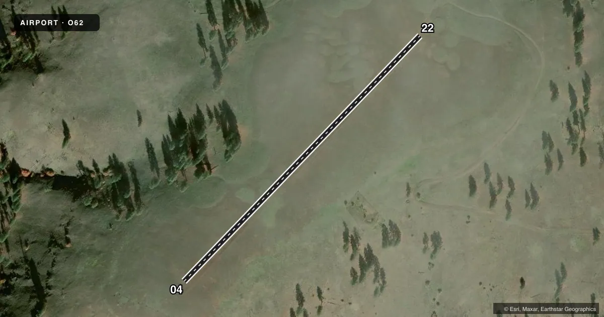
Runways & pattern
Full pagePattern entry · RWY 04
LEFT TRAFFICAirport sketch
Runways drawn to scale from FAA survey coordinates, rendered over satellite imagery. Not for navigation.
Approaches & charts
Services on the field
Fuel grades, oxygen, maintenance, ramp storage and lighting — as declared to the FAA by the airport operator.
Fuel & services
- Fuel
- Not available
Ramp & ground
- Transient storage
- Not published
- Wind indicator
- Yes
Fuel & FBOs
Cheapest 100LL and Jet A on the field and nearby. Always confirm with the FBO before taxi.
Airport notes
Surface conditions, obstructions, local procedures, lighting outages and other notes published with each FAA cycle.
General notes
- USE CTN FOR DEER AND ELK INVOF ARPT.
- SNGL ENG ACFT WITH A WINGSPAN OF LESS THAN 45 FT.
- ARPT DESIRES CHARTING.
VFR map & nearby airports
VFR sectional. Tap any ICAO chip to open that airport.
Key facts · O62
Answer card- ICAO
- O62
- Name
- B & H USFS
- Location
- ENTERPRISE, OREGON
- Elevation
- 4,007 ft MSL
- Traffic pattern altitude
- 5,007 ft MSL (1,000 AGL)
- Control tower
- Non-towered (use CTAF)
- Total runways
- 1
- Longest runway
- 04/22 · 1,850 ft
- Published ILS approaches
- 0
- Published frequencies
- 1
- Magnetic variation
- –
- Current flight rules
- VFR
- Current wind
- 050° at 3 kt
- Favored runway now
- RWY 04
B & H USFS Airport (O62) sits near Enterprise, Oregon. Field elevation is 4,007 ft MSL. The airport has one runway. Runway 04/22 is 1,850 ft long and turf. There is no control tower. CTAF is 122.9. No ILS approaches are published here.
The pattern altitude is not published. For local pattern work, use the standard 1,000 ft AGL unless the current Chart Supplement says otherwise. This is a high-elevation strip, so performance planning matters. Expect thinner air than you get at lower fields. The published remarks also call out that the airport wants charting. They note single-engine aircraft with a wingspan of less than 45 ft. Wildlife is a factor here too. Deer and elk are mentioned in the vicinity of the airport. Use a careful scan on taxi, takeoff and landing. No on-field FBOs are listed, so verify services with the airport operator or the FBO directly by phone before you go.