METAR & TAF 25U
25U does not publish a METAR.
Showing the nearest reporting station: KJSY (JOSEPH STATE) · 24.0 NM away. Conditions at 25U may differ.
METAR · KJSY
Observed 11:55Z
KJSY 271155Z AUTO 19003KT 10SM CLR 12/06 A3016 RMK AO2 T01150055 10140 20105
- Wind
- 190° @ 3 kt
- Visibility
- 10 SM
- Temp / Dew
- 12°C / 6°C
- Altimeter
- 30.16 inHg
- Clouds
- CLR
- Density alt
- 7,660 ft
- Ceiling
- Unlimited
- Rules
- VFR
Airport info & contacts
Manager on record, flight service, ARTCC, attendance schedule and pattern altitude — published by the FAA and refreshed every 28 days.
Location
- From city
- 10 NM SE
- VFR sectional
- GREAT FALLS
- ARTCC
- ZSE · SEATTLE
- NOTAM facility
- MMV (NOTAM-D)
Airport manager
- Name
- BRANDON CULLEY-UNIT AVIATION OFFICE
- Phone
- 541-963-7171
- Address
- 59973 DOWNS RD, LA GRANDE OR 97850
Flight service · Hours
- FSS MMV
- MC MINNVILLE1-800-WX-BRIEF
- Attendance
- Unattended
Frequencies
Tap any row to copy the frequency to your clipboard.
Runways & pattern
Full pagePattern entry · RWY 17
RIGHT TRAFFICRunway end performance
| End | TORA | TODA | ASDA | LDA | VGSI | Approach lights | Obstruction |
|---|---|---|---|---|---|---|---|
| 17 | — | — | — | — | — | — | 15', trees, 50' from thr, 0' R of cntrln, slope 3 |
| 35 | — | — | — | — | — | — | 10', tree, 378' from thr, 0' R of cntrln, slope 37 |
Declared distances in feet. TORA = takeoff run available, TODA = takeoff distance, ASDA = accelerate-stop, LDA = landing distance.
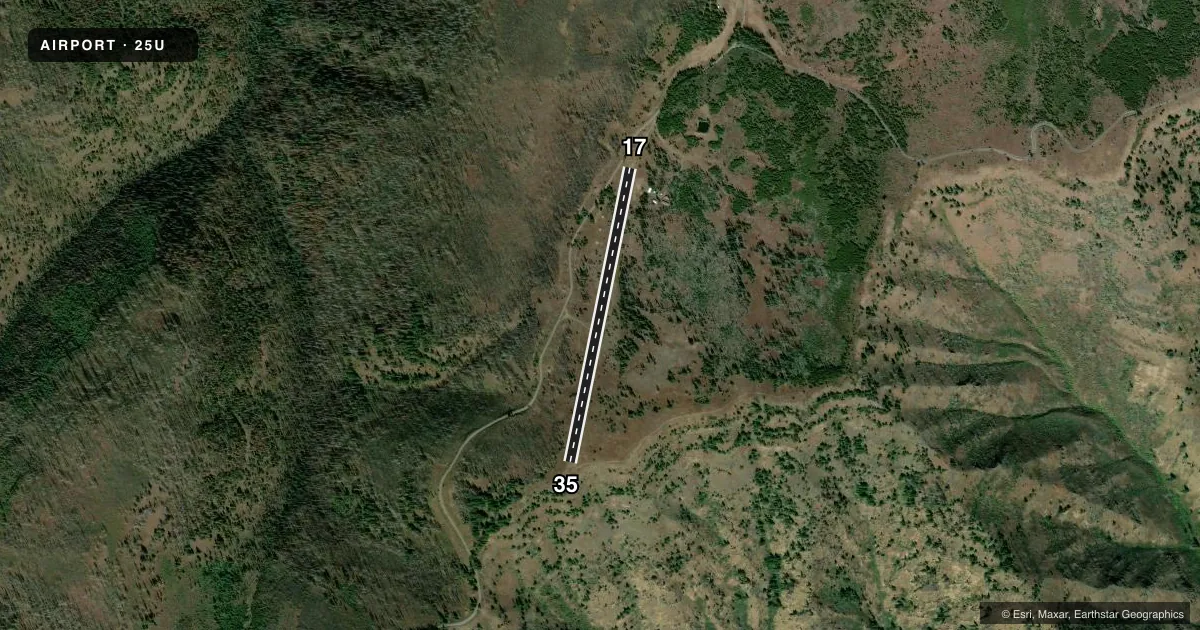
Airport sketch
Runways drawn to scale from FAA survey coordinates, rendered over satellite imagery. Not for navigation.
Approaches & charts
Services on the field
Fuel grades, oxygen, maintenance, ramp storage and lighting — as declared to the FAA by the airport operator.
Fuel & services
- Fuel
- Not available
- Oxygen (bottled)
- Not available
- Oxygen (bulk)
- Not available
- Airframe repair
- Not available
- Power plant repair
- Not available
Ramp & ground
- Transient storage
- Not published
- Landing fee
- No fee published
- Wind indicator
- Yes
- Segmented circle
- No
Fuel & FBOs
Cheapest 100LL and Jet A on the field and nearby. Always confirm with the FBO before taxi.
Airport notes
Surface conditions, obstructions, local procedures, lighting outages and other notes published with each FAA cycle.
General notes
- CLSD WINTERS
- EARLY SPRING: DAMP SOFT SPOT ON NORTH END OF RWY; LAND LONG TO SOUTH.
- RY 35 EXPECT DOWNDRAFTS ON SHORT FINAL DUE TO SHEER DROP IN TERRAIN.
- LIVESTOCK AND WILDLIFE ON & INVOF ARPT.
- RY 17 SLOPES UP 2.5 % TO SOUTH.
- NO LINE OF SIGHT BTN RY ENDS.
- RY 35 HAS 9 INCH BERM ALONG L SHOULDER 500 FT.
- FOR CD CTC SEATTLE ARTCC AT 253-351-3694.
Approach & departure obstructions
- 35THLD MKD BY WHITE ROCKS ACROSS RY END.
Other notes
- ESTABD PRIOR TO 1959.
- 17/35LOOSE 3 IN - 6 IN ROCKS ON RWY; RWY FAIR DEFINED FOR GRVL TURF RWY. SOUTH 1000 FT RUF & OVERGROWN WITH WEEDS.
VFR map & nearby airports
VFR sectional. Tap any ICAO chip to open that airport.
Key facts · 25U
Answer card- ICAO
- 25U
- Name
- MEMALOOSE USFS
- Location
- IMNAHA, OREGON
- Elevation
- 6,708 ft MSL
- Traffic pattern altitude
- 7,708 ft MSL (1,000 AGL)
- Control tower
- Non-towered (use CTAF)
- Total runways
- 1
- Longest runway
- 17/35 · 3,300 ft
- Published ILS approaches
- 0
- Published frequencies
- 1
- Magnetic variation
- 18°
- Current flight rules
- VFR
- Current wind
- 190° at 3 kt
- Favored runway now
- RWY 17
MEMALOOSE USFS (25U) sits near Imnaha, Oregon. Field elevation is 6,708 ft MSL. The airport has one runway. Runway 17/35 is 3,300 ft long and surfaced with dirt. There is no control tower. CTAF is 122.9. No ILS approaches are published.
Pattern altitude is not published. Use standard 1,000 ft AGL for light piston operations unless the current FAA Chart Supplement says otherwise. At this elevation, performance planning matters. The field also has terrain issues that deserve attention on both ends. Runway 17 slopes up 2.5 percent to the south. Runway 35 can produce downdrafts on short final because of the drop in terrain. The runway ends are not in line of sight with each other.
Published remarks also call out loose rocks on the surface. The south 1,000 feet is rough and overgrown with weeds. Runway 35 has a berm along the left shoulder for about 500 feet. The threshold is marked by white rocks at the runway end. Livestock and wildlife have been reported on and near the airport. The field is closed in winter. No on-field FBOs are listed, so verify services with the airport operator or call the field directly before you go.