METAR & TAF KJSY
Current METAR
Observed 06:55Z
KJSY 270655Z AUTO 20003KT 10SM CLR 13/07 A3016 RMK AO2 T01340071
- Wind
- 200° @ 3 kt
- Visibility
- 10 SM
- Temp / Dew
- 13°C / 7°C
- Altimeter
- 30.16 inHg
- Clouds
- CLR
- Density alt
- 4,579 ft
- Ceiling
- Unlimited
- Rules
- VFR
Airport info & contacts
Manager on record, flight service, ARTCC, attendance schedule and pattern altitude — published by the FAA and refreshed every 28 days.
Location
- From city
- 1 NM W
- VFR sectional
- SEATTLE
- ARTCC
- ZSE · SEATTLE
- NOTAM facility
- MMV (NOTAM-D)
Airport manager
- Name
- STATE AIRPORTS MGR
- Phone
- 503-378-4880
- Address
- 3040 25TH ST SE, SALEM OR 97302-1125
Flight service · Hours
- FSS MMV
- MC MINNVILLE1-800-WX-BRIEF
- Attendance
- Unattended
Frequencies
Tap any row to copy the frequency to your clipboard.
Runways & pattern
Full pagePattern entry · RWY 15
LEFT TRAFFICRunway end performance
| End | TORA | TODA | ASDA | LDA | VGSI | Approach lights | Obstruction |
|---|---|---|---|---|---|---|---|
| 15 | — | — | — | — | PAPI 2-box left(4°) | — | 61', trees, 1470' from thr, 30' R of cntrln, slope 20 |
| 33 | — | — | — | — | — | — | 32', pline, 1100' from thr, 0' R of cntrln, slope 28 |
Declared distances in feet. TORA = takeoff run available, TODA = takeoff distance, ASDA = accelerate-stop, LDA = landing distance.
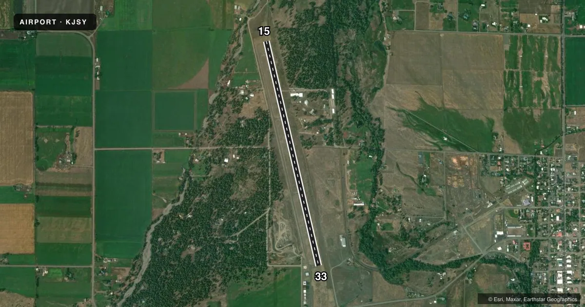
Airport sketch
Runways drawn to scale from FAA survey coordinates, rendered over satellite imagery. Not for navigation.
Approaches & charts
Services on the field
Fuel grades, oxygen, maintenance, ramp storage and lighting — as declared to the FAA by the airport operator.
Fuel & services
- Fuel
- 100LL
- Oxygen (bottled)
- Not available
- Oxygen (bulk)
- Not available
- Airframe repair
- Not available
- Power plant repair
- Not available
Ramp & ground
- Transient storage
- Tie-down
- Landing fee
- No fee published
- Customs
- Not available
- Lighting schedule
- SEE RMK
- Beacon schedule
- SS-SR
- Beacon
- White / Green (civil land)(WG)
- Wind indicator
- Lighted
- Segmented circle
- Yes
Fuel & FBOs
Cheapest 100LL and Jet A on the field and nearby. Always confirm with the FBO before taxi.
Airport notes
Surface conditions, obstructions, local procedures, lighting outages and other notes published with each FAA cycle.
General notes
- DURING SOUTH TAKEOFFS, POSSIBLE HAZARDOUS DOWNDRAFTS SOUTH OF ARPT UNDER SOUTH WND CONDITIONS.
- POSS DEER ON ARPT USE CTN.
- PLINES NEAR RY 33 AER UNMARKED.
- RUNWAY ENDS NOT VISIBLE FROM EACH OTHER.
- SURFACE CONDITIONS NOT REPORTED.
- FOR CD CTC SEATTLE ARTCC AT 253-351-3694.
Lighting notes
- ACTVT REIL RWY 15; PAPI RWY 15; MIRL RWY 15/33 - CTAF.
VFR map & nearby airports
VFR sectional. Tap any ICAO chip to open that airport.
Key facts · KJSY
Answer card- ICAO
- KJSY
- Name
- JOSEPH STATE
- Location
- JOSEPH, OREGON
- Elevation
- 4,126.2 ft MSL
- Traffic pattern altitude
- 5,126.2 ft MSL (1,000 AGL)
- Control tower
- Non-towered (use CTAF)
- Total runways
- 1
- Longest runway
- 15/33 · 5,202 ft
- Published ILS approaches
- 0
- Published frequencies
- 2
- Magnetic variation
- 13°
- Current flight rules
- VFR
- Current wind
- 200° at 3 kt
- Favored runway now
- RWY 15
Joseph State Airport sits in Joseph, Oregon. The field elevation is 4,126.2 ft MSL. It has one runway, 15/33, which is 5,202 ft long with an asphalt surface. The airport is not towered. CTAF and UNICOM are both 122.8.
No ILS approaches are published here. The pattern altitude is not published, so use the standard 1,000 ft AGL for light piston operations unless the current Chart Supplement says otherwise. Joseph State Airport has one on-field FBO. Joseph State Airport carries AVGAS 100LL. Call (503) 378-4880 for current service details.
A few local items matter here. Runway 15 has REIL and PAPI lighting. Runways 15 and 33 have medium intensity runway lighting controlled by CTAF. Runway ends are not visible from each other. Power lines near runway 33 are unmarked. Deer have been reported on the airport. During south takeoffs, hazardous downdrafts may occur south of the airport under south wind conditions. The field sits high enough that density altitude can matter, so plan performance carefully. For clearance delivery, contact Seattle ARTCC at 253-351-3694.