METAR & TAF 8S4
8S4 does not publish a METAR.
Showing the nearest reporting station: KJSY (JOSEPH STATE) · 3.9 NM away. Conditions at 8S4 may differ.
METAR · KJSY
Observed 05:55Z
KJSY 270555Z AUTO 00000KT 7SM CLR 14/07 A3014 RMK AO2 T01390074 10274 20139
- Wind
- 000° @ 0 kt
- Visibility
- 7 SM
- Temp / Dew
- 14°C / 7°C
- Altimeter
- 30.14 inHg
- Clouds
- CLR
- Density alt
- 4,514 ft
- Ceiling
- Unlimited
- Rules
- VFR
Airport info & contacts
Manager on record, flight service, ARTCC, attendance schedule and pattern altitude — published by the FAA and refreshed every 28 days.
Location
- From city
- 0 NM E
- VFR sectional
- SEATTLE
- ARTCC
- ZSE · SEATTLE
- NOTAM facility
- MMV (NOTAM-D)
Airport manager
- Name
- LUCAS STANGEL
- Phone
- 541-805-9381
- Address
- P O BOX 157, ENTERPRISE OR 97828
Flight service · Hours
- FSS MMV
- MC MINNVILLE1-800-WX-BRIEF
- Attendance
- ON CALL
Frequencies
Tap any row to copy the frequency to your clipboard.
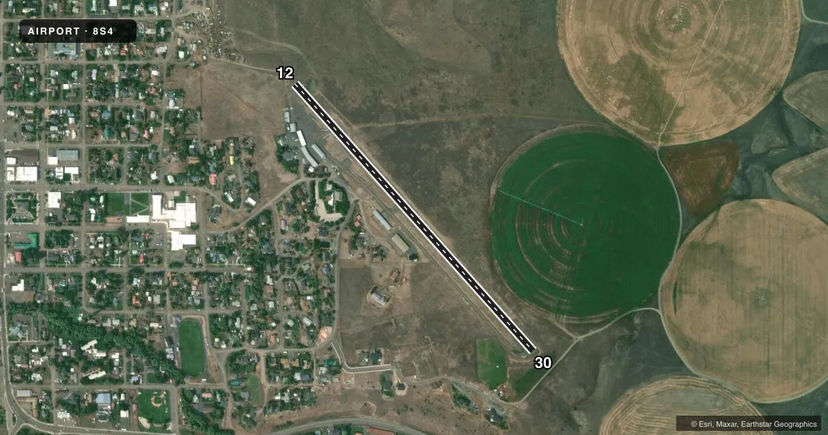
Runways & pattern
Full pagePattern entry · RWY 12
LEFT TRAFFICAirport sketch
Runways drawn to scale from FAA survey coordinates, rendered over satellite imagery. Not for navigation.
Approaches & charts
Services on the field
Fuel grades, oxygen, maintenance, ramp storage and lighting — as declared to the FAA by the airport operator.
Fuel & services
- Fuel
- 100LL
- Oxygen (bottled)
- Not available
- Oxygen (bulk)
- Not available
- Airframe repair
- Not available
- Power plant repair
- Not available
- Other services
- CHTR,INSTR
Ramp & ground
- Transient storage
- Tie-down
- Landing fee
- No fee published
- Customs
- Not available
- Lighting schedule
- SEE RMK
- Beacon schedule
- SS-SR
- Beacon
- White / Green (civil land)(WG)
- Wind indicator
- Lighted
- Segmented circle
- Yes
Fuel & FBOs
Cheapest 100LL and Jet A on the field and nearby. Always confirm with the FBO before taxi.
Airport notes
Surface conditions, obstructions, local procedures, lighting outages and other notes published with each FAA cycle.
General notes
- NO LINE OF SIGHT FM RWY ENDS. ANNOUNCE INTENTIONS ARRG/DEPG ON 122.8.
- UNLGTD HELIPAD 150 FT SE OF ROTG BCN ADJ TO TWY.
- PARL TWY 20 FT WIDE; LOOSE GRVL ON SFC.
- BE ALERT; SOFT EDGES AND STEEP SHOULDERS ALONG RWY & TWY.
- 65 FT LGTD CELL TWR 200 FT SW OF RWY 12.
Lighting notes
- ACTVT HIRL RWY 12/30 - CTAF.
Fuel notes
- 100LLCALL 541-805-0364 OR 541-805-9381.
Approach & departure obstructions
- 123 FT FENCE 50 FT FM THLD 60 FT L OF CNTRLN.
- 304 FT FENCE 108 FT R AT END.
- 12RWY 12/30 NSTD BSC MARKINGS; NUMBERS SMALL.
Other notes
- 1FOR ATTENDANT CALL 541-805-9381 OR 541-805-0364.
VFR map & nearby airports
VFR sectional. Tap any ICAO chip to open that airport.
Key facts · 8S4
Answer card- ICAO
- 8S4
- Name
- ENTERPRISE MUNI
- Location
- ENTERPRISE, OREGON
- Elevation
- 3,957 ft MSL
- Traffic pattern altitude
- 4,957 ft MSL (1,000 AGL)
- Control tower
- Non-towered (use CTAF)
- Total runways
- 1
- Longest runway
- 12/30 · 2,850 ft
- Published ILS approaches
- 0
- Published frequencies
- 2
- Magnetic variation
- 18°
- Current flight rules
- VFR
- Current wind
- 000° at 0 kt
- Favored runway now
- –
Enterprise Muni sits in Enterprise, Oregon at 3,957 ft MSL. It has one runway, 12/30, which is 2,850 ft long. There is no control tower. CTAF and UNICOM are both 122.8. No ILS approaches are published here.
Pattern altitude is not published. Use the standard 1,000 ft AGL unless the current Chart Supplement says otherwise. Stangel Flight Service is on the field. It carries 100LL. Call ahead if you need an attendant or fuel service. The published remarks also note high intensity runway lights on 12/30 that are activated by CTAF. Runway 12/30 has nonstandard basic markings with small numbers.
This is a high-elevation field, so performance planning matters. Expect thinner air than at low country airports. The remarks also call out soft edges and steep shoulders along the runway and taxiway. The parallel taxiway is 20 ft wide with loose gravel. There is no line of sight from the runway ends. Announce your intentions on 122.8 when arriving or departing. There is also a 65 ft lighted cellular tower southwest of runway 12. Fence obstructions sit near both runway ends. Check your climb and landing margins before you go.