METAR & TAF O68
O68 does not publish a METAR.
Showing the nearest reporting station: KJSY (JOSEPH STATE) · 28.7 NM away. Conditions at O68 may differ.
METAR · KJSY
Observed 12:55Z
KJSY 271255Z AUTO 19005KT 10SM CLR 14/05 A3016 RMK AO2 T01350050
- Wind
- 190° @ 5 kt
- Visibility
- 10 SM
- Temp / Dew
- 14°C / 5°C
- Altimeter
- 30.16 inHg
- Clouds
- CLR
- Density alt
- 1,281 ft
- Ceiling
- Unlimited
- Rules
- VFR
Airport info & contacts
Manager on record, flight service, ARTCC, attendance schedule and pattern altitude — published by the FAA and refreshed every 28 days.
Location
- From city
- 13 NM SE
- VFR sectional
- GREAT FALLS
- ARTCC
- ZSE · SEATTLE
- NOTAM facility
- MMV
Airport manager
- Name
- USFS-WWF
- Phone
- 541-963-7171
- Address
- 59973 DOWN RD, LAGRANDE OR 98750
Flight service · Hours
- FSS MMV
- MC MINNVILLE1-800-WX-BRIEF
Frequencies
Tap any row to copy the frequency to your clipboard.
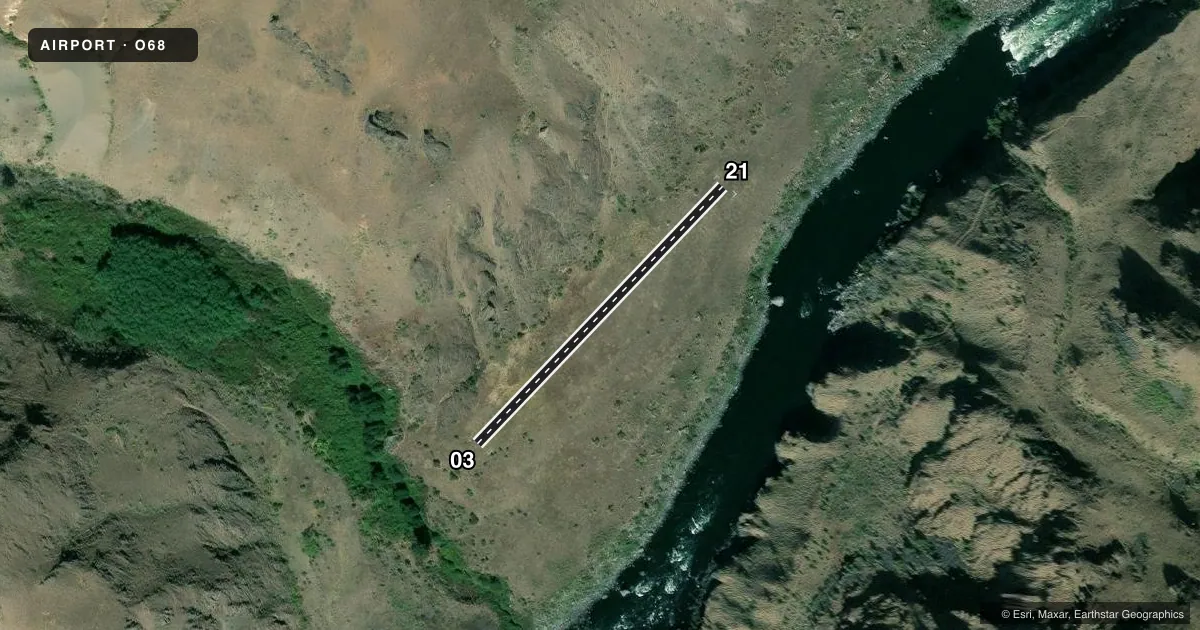
Runways & pattern
Full pagePattern entry · RWY 21
LEFT TRAFFICAirport sketch
Runways drawn to scale from FAA survey coordinates, rendered over satellite imagery. Not for navigation.
Approaches & charts
Services on the field
Fuel grades, oxygen, maintenance, ramp storage and lighting — as declared to the FAA by the airport operator.
Fuel & services
- Fuel
- Not available
Ramp & ground
- Transient storage
- Not published
Fuel & FBOs
Cheapest 100LL and Jet A on the field and nearby. Always confirm with the FBO before taxi.
Airport notes
Surface conditions, obstructions, local procedures, lighting outages and other notes published with each FAA cycle.
Other notes
- MANAGERBRANDON.CULLEY@USDA.GOV
VFR map & nearby airports
VFR sectional. Tap any ICAO chip to open that airport.
Key facts · O68
Answer card- ICAO
- O68
- Name
- SLUICE CREEK
- Location
- IMNAHA, OREGON
- Elevation
- 1,370 ft MSL
- Traffic pattern altitude
- 2,370 ft MSL (1,000 AGL)
- Control tower
- Non-towered (use CTAF)
- Total runways
- 1
- Longest runway
- 03/21 · 976 ft
- Published ILS approaches
- 0
- Published frequencies
- 1
- Magnetic variation
- –
- Current flight rules
- VFR
- Current wind
- 190° at 5 kt
- Favored runway now
- RWY 21
Sluice Creek Airport (O68) sits in Imnaha, Oregon. Field elevation is 1,370 ft MSL. The airport has one runway. Runway 03/21 is 976 ft long and surfaced with turf. The field is not towered. CTAF is 122.9.
No ILS approaches are published here. Pattern altitude is not published, so verify the current traffic pattern before you go. The published runway headings are magnetic. Runway 03 is 43.5962194172954 degrees magnetic. Runway 21 is 223.596219417295 degrees magnetic.
There are no on-field FBOs listed. Plan on self-sufficiency and confirm current services with the airport operator before arrival. The FAA remarks list the airport manager contact as brandon.culley@usda.gov. For a first-time visit, treat this as a small turf strip with limited published data. Check the current Chart Supplement for any local procedures. Be ready for a short-field setup on a 976 ft runway.