METAR & TAF O29
O29 does not publish a METAR.
Showing the nearest reporting station: KGIC (IDAHO COUNTY) · 23.9 NM away. Conditions at O29 may differ.
METAR · KGIC
Observed 06:15Z
KGIC 270615Z AUTO 00000KT 10SM CLR 17/05 A3009 RMK AO1
- Wind
- 000° @ 0 kt
- Visibility
- 10 SM
- Temp / Dew
- 17°C / 5°C
- Altimeter
- 30.09 inHg
- Clouds
- CLR
- Density alt
- 1,499 ft
- Ceiling
- Unlimited
- Rules
- VFR
Airport info & contacts
Manager on record, flight service, ARTCC, attendance schedule and pattern altitude — published by the FAA and refreshed every 28 days.
Location
- From city
- 16 NM ENE
- VFR sectional
- GREAT FALLS
- ARTCC
- ZSE · SEATTLE
- NOTAM facility
- MMV
Airport manager
- Name
- UNITED STATES FOREST SERVICE-WWF
- Phone
- 541-963-7171
- Address
- 59973 DOWNS RD., LAGRANDE OR 97850
Flight service · Hours
- FSS MMV
- MC MINNVILLE1-800-WX-BRIEF
Frequencies
Tap any row to copy the frequency to your clipboard.
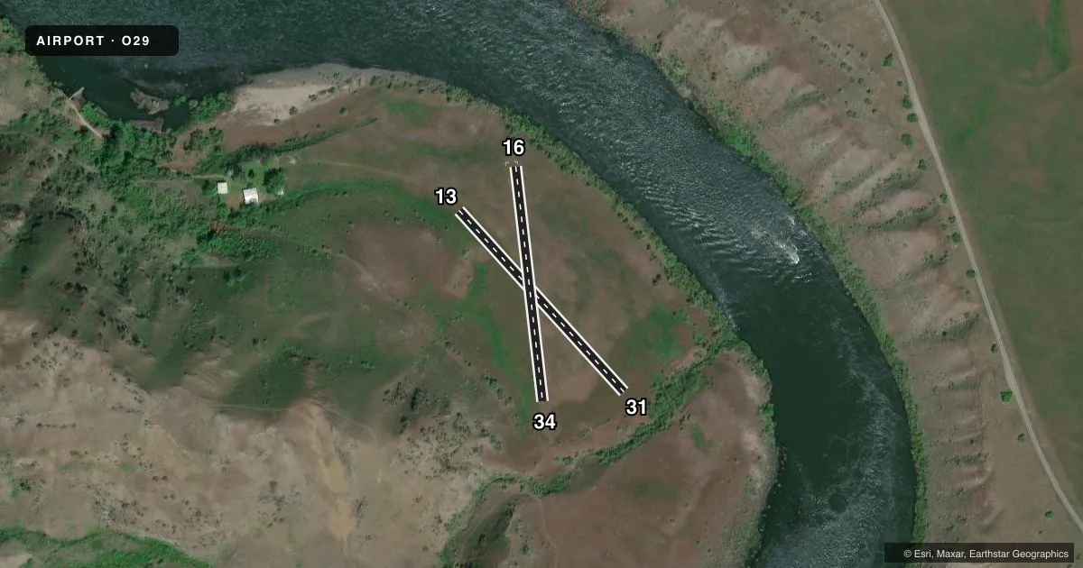
Runways & pattern
Full pagePattern entry · RWY 13
LEFT TRAFFICAirport sketch
Runways drawn to scale from FAA survey coordinates, rendered over satellite imagery. Not for navigation.
Approaches & charts
Services on the field
Fuel grades, oxygen, maintenance, ramp storage and lighting — as declared to the FAA by the airport operator.
Fuel & services
- Fuel
- Not available
Ramp & ground
- Transient storage
- Not published
Fuel & FBOs
Cheapest 100LL and Jet A on the field and nearby. Always confirm with the FBO before taxi.
Airport notes
Surface conditions, obstructions, local procedures, lighting outages and other notes published with each FAA cycle.
Other notes
- MANAGERBRANDON.CULLEY@USDA.GOV
VFR map & nearby airports
VFR sectional. Tap any ICAO chip to open that airport.
Key facts · O29
Answer card- ICAO
- O29
- Name
- PITTSBURG LANDING
- Location
- IMNAHA, OREGON
- Elevation
- 1,185 ft MSL
- Traffic pattern altitude
- 2,185 ft MSL (1,000 AGL)
- Control tower
- Non-towered (use CTAF)
- Total runways
- 2
- Longest runway
- 13/31 · 744 ft
- Published ILS approaches
- 0
- Published frequencies
- 1
- Magnetic variation
- –
- Current flight rules
- VFR
- Current wind
- 000° at 0 kt
- Favored runway now
- –
Pittsburg Landing is in Imnaha, Oregon. Field elevation is 1,185 ft MSL. This is a small nontowered airport with two turf runways. The longest runway is 744 ft. Runway 13/31 is 744 ft. Runway 16/34 is 718 ft. No ILS approaches are published here.
Pattern altitude is not published. Use the standard 1,000 ft AGL pattern for light piston traffic unless the current FAA Chart Supplement says otherwise. CTAF is 122.9. With no control tower, you need to self-announce clearly and keep a close eye out for other traffic. The airport manager can be contacted at brandon.culley@usda.gov.
There are no on-field FBOs listed in the facts. Plan on self-sufficiency and verify current services with the airport operator before you go. The field sits in a remote part of eastern Oregon, so check runway condition and local terrain before arrival. Short turf strips leave little room for error. Use the current FAA Chart Supplement for any unpublished operational details before flying in.