METAR & TAF S68
S68 does not publish a METAR.
Showing the nearest reporting station: KLWS (LEWISTON/NEZ PERCE COUNTY) · 31.4 NM away. Conditions at S68 may differ.
METAR · KLWS
Observed 13:56Z
KLWS 271356Z 16003KT 6SM HZ CLR 18/05 A3005 RMK AO2 SLP168 T01780050 $
- Wind
- 160° @ 3 kt
- Visibility
- 6 SM
- Temp / Dew
- 18°C / 5°C
- Altimeter
- 30.05 inHg
- Clouds
- CLR
- Density alt
- 1,445 ft
- Ceiling
- Unlimited
- Rules
- VFR
Airport info & contacts
Manager on record, flight service, ARTCC, attendance schedule and pattern altitude — published by the FAA and refreshed every 28 days.
Location
- From city
- 1 NM NW
- VFR sectional
- GREAT FALLS
- ARTCC
- ZSE · SEATTLE
- NOTAM facility
- BOI (NOTAM-D)
Airport manager
- Name
- RYAN SMATHERS
- Phone
- 208-476-4725
- Address
- 217 FIRST ST, OROFINO ID 83544
Flight service · Hours
- FSS BOI
- BOISE1-800-WX-BRIEF
- Attendance
- Unattended
Frequencies
Tap any row to copy the frequency to your clipboard.
Runways & pattern
Full pagePattern entry · RWY 08
RIGHT TRAFFICRunway end performance
| End | TORA | TODA | ASDA | LDA | VGSI | Approach lights | Obstruction |
|---|---|---|---|---|---|---|---|
| 08 | — | — | — | — | — | — | 65', tree, 200' from thr, 100' R of cntrln, slope 0 |
| 26 | — | — | — | — | — | — | 65', tree, 1125' from thr, 175' R of cntrln, slope 14 |
Declared distances in feet. TORA = takeoff run available, TODA = takeoff distance, ASDA = accelerate-stop, LDA = landing distance.
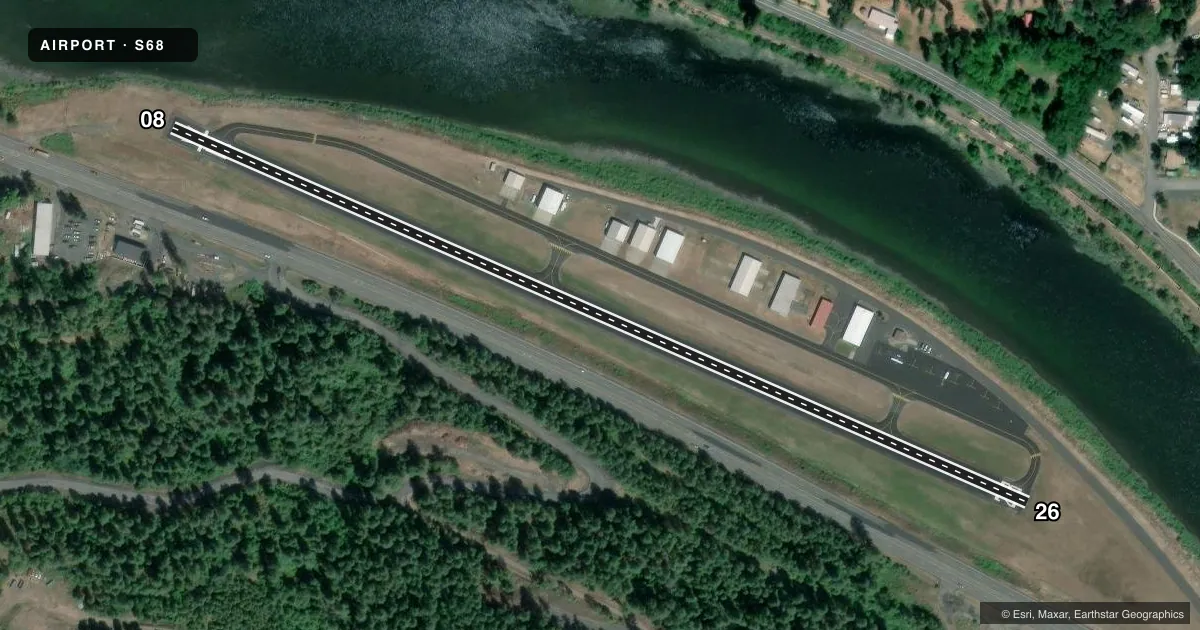
Airport sketch
Runways drawn to scale from FAA survey coordinates, rendered over satellite imagery. Not for navigation.
Approaches & charts
Services on the field
Fuel grades, oxygen, maintenance, ramp storage and lighting — as declared to the FAA by the airport operator.
Fuel & services
- Fuel
- 100LL
- Other services
- AMB
Ramp & ground
- Transient storage
- Tie-down
- Landing fee
- No fee published
- Customs
- Not available
- Lighting schedule
- SEE RMK
- Wind indicator
- Lighted
- Segmented circle
- No
Fuel & FBOs
Cheapest 100LL and Jet A on the field and nearby. Always confirm with the FBO before taxi.
Airport notes
Surface conditions, obstructions, local procedures, lighting outages and other notes published with each FAA cycle.
General notes
- CTN: HIGH MTUS TIMBERED TRRN ALL QUADS; BE ALERT DURG NGT OPS.
- FOR CD CTC SEATTLE ARTCC AT 253-351-3694.
Lighting notes
- ACTVT RWY 08/26 MIRL - CTAF.
Fuel notes
- 100LLAVBL H24 WITH CREDIT CARD.
Approach & departure obstructions
- 086 FT FENCE AT THR 100 FT R.
- 26+13 FT ROAD AT THR 110 FT R.
- 26TWO 250 FT TWRS 1 MI E 300 FT L.
VFR map & nearby airports
VFR sectional. Tap any ICAO chip to open that airport.
Key facts · S68
Answer card- ICAO
- S68
- Name
- OROFINO MUNI
- Location
- OROFINO, IDAHO
- Elevation
- 1,004.7 ft MSL
- Traffic pattern altitude
- 2,004.7 ft MSL (1,000 AGL)
- Control tower
- Non-towered (use CTAF)
- Total runways
- 1
- Longest runway
- 08/26 · 2,520 ft
- Published ILS approaches
- 0
- Published frequencies
- 2
- Magnetic variation
- 18°
- Current flight rules
- VFR
- Current wind
- 160° at 3 kt
- Favored runway now
- RWY 08
Orofino Muni is in Orofino, Idaho. Field elevation is 1,004.7 ft MSL. The airport has one runway. Runway 08/26 is 2,520 ft long with asphalt pavement. There is no control tower. CTAF and UNICOM are both 122.8. No ILS approaches are published.
Pattern altitude is not published, so use the standard 1,000 ft AGL for light piston operations unless the current FAA Chart Supplement says otherwise. The field sits in high mountainous timbered terrain in all quadrants. That matters at night and in lower visibility. Published remarks also call out a road near the threshold of runway 26. They also note a fence near the threshold of runway 08. Two 250 ft towers sit about 1 mile east of the field. Runway 08/26 has medium intensity lights that are activated by CTAF.
Orofino Municipal Airport is the on-field FBO. It carries 100LL. Fuel is available 24 hours with a credit card. For clearance delivery, contact Seattle ARTCC at 253-351-3694. If you are new to the airport, plan for the terrain, the short runway and the published obstructions near both ends. Check the current FAA Chart Supplement before flight for any updates.