METAR & TAF 0S5
0S5 does not publish a METAR.
Showing the nearest reporting station: KGIC (IDAHO COUNTY) · 18.4 NM away. Conditions at 0S5 may differ.
METAR · KGIC
Observed 17:55Z
KGIC 261755Z AUTO 05007KT 10SM CLR 23/08 A3009 RMK AO1
- Wind
- 050° @ 7 kt
- Visibility
- 10 SM
- Temp / Dew
- 23°C / 8°C
- Altimeter
- 30.09 inHg
- Clouds
- CLR
- Density alt
- 4,722 ft
- Ceiling
- Unlimited
- Rules
- VFR
Airport info & contacts
Manager on record, flight service, ARTCC, attendance schedule and pattern altitude — published by the FAA and refreshed every 28 days.
Location
- From city
- 0 NM NE
- VFR sectional
- GREAT FALLS
- ARTCC
- ZSE · SEATTLE
- NOTAM facility
- BOI (NOTAM-D)
Airport manager
- Name
- STEVE BATEMAN
- Phone
- 208-790-1999
- Address
- 411 4TH AVE, NEZPERCE ID 83543
Flight service · Hours
- FSS BOI
- BOISE1-800-WX-BRIEF
- Attendance
- APR-OCT · MON-FRI · 0800-1700
- NOV-MAR · IREG · IREG
Frequencies
Tap any row to copy the frequency to your clipboard.
Runways & pattern
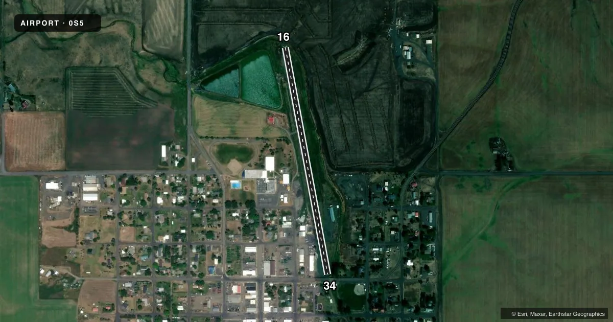
Full pagePattern entry · RWY 34
LEFT TRAFFICRunway end performance
| End | TORA | TODA | ASDA | LDA | VGSI | Approach lights | Obstruction |
|---|---|---|---|---|---|---|---|
| 16 | — | — | — | — | — | — | 75', hill, 0' R of cntrln, slope 8 |
| 34 | — | — | — | — | — | — | 28', tree, 90' R of cntrln, slope 3 |
Declared distances in feet. TORA = takeoff run available, TODA = takeoff distance, ASDA = accelerate-stop, LDA = landing distance.
Airport sketch
Runways drawn to scale from FAA survey coordinates, rendered over satellite imagery. Not for navigation.
Approaches & charts
Services on the field
Fuel grades, oxygen, maintenance, ramp storage and lighting — as declared to the FAA by the airport operator.
Fuel & services
- Fuel
- Not available
- Oxygen (bottled)
- Not available
- Oxygen (bulk)
- Not available
- Airframe repair
- Not available
- Power plant repair
- Not available
- Other services
- AGRI
Ramp & ground
- Transient storage
- Tie-down
- Landing fee
- No fee published
- Customs
- Not available
- Wind indicator
- Yes
- Segmented circle
- No
Fuel & FBOs
Cheapest 100LL and Jet A on the field and nearby. Always confirm with the FBO before taxi.
Airport notes
Surface conditions, obstructions, local procedures, lighting outages and other notes published with each FAA cycle.
General notes
- CSDRBL AGRICULTURAL SPRAYING OPS DURG GROWING SEASON (MAY-SEP).
- FOR CD CTC SEATTLE ARTCC AT 253-351-3694.
Approach & departure obstructions
- 16RWY 15 HAS 604 FT DTHR AND 1 FT BRIDGE ABUTMENTS 30 FT FM EDGE OF PAVEMENT, LEFT & RIGHT.
- 34RWY 33 HAS 550 FT DTHR DUE TO 17 FT ROAD (ROAD IS 8 FT HYR ABV RWY 33) 35 FT ON CNTRLN; 10 FT SIGN 55 FT, 63 LEFT; 6 FT FENCE 15 FT ON CNTRLN; 15 FT SIGN 35 FT ON CNTRLN; 85 FT TREES 0 FT, 90 FT RIGHT.
- 16EXCELLENT RWY MARKINGS SHOWING RWY NRS, DTHR BAR AND CNTRLN.
- 34NMRS ADDNL OBSTNS ON APCH.
Other notes
- ESTABD PRIOR TO 5/15/59.
- OWNEROR 208-937-2652.
VFR map & nearby airports
VFR sectional. Tap any ICAO chip to open that airport.
Key facts · 0S5
Answer card- ICAO
- 0S5
- Name
- NEZPERCE MUNI
- Location
- NEZPERCE, IDAHO
- Elevation
- 3,204 ft MSL
- Traffic pattern altitude
- 4,204 ft MSL (1,000 AGL)
- Control tower
- Non-towered (use CTAF)
- Total runways
- 1
- Longest runway
- 16/34 · 2,443 ft
- Published ILS approaches
- 0
- Published frequencies
- 1
- Magnetic variation
- 18°
- Current flight rules
- VFR
- Current wind
- 050° at 7 kt
- Favored runway now
- RWY 34
Nezperce Muni is in Nezperce, Idaho. The field elevation is 3,204 ft MSL. It has one runway. The longest runway is 16/34 at 2,443 ft asphalt. There is no control tower. CTAF is 122.9. No ILS approaches are published.
Pattern altitude is not published. Use the standard 1,000 ft AGL for light piston traffic unless the current Chart Supplement says otherwise. That puts the pattern at about 4,204 ft MSL based on field elevation. Verify the published pattern before you fly. Runway 16 has good markings. The remarks also note a displaced threshold on one end and several obstructions on the opposite end. Runway 34 has a displaced threshold with road and terrain-related obstructions in the approach area. Expect to brief the runway carefully before arrival.
This is an uncontrolled field with agricultural spraying activity during the growing season from May through September. Give yourself room for traffic scans and be ready for low-level local work. For clearance delivery, contact Seattle ARTCC at 253-351-3694. There are no on-field FBOs listed. Plan ahead and confirm services with the airport operator or by calling the field directly before you go.