METAR & TAF KBKE
Current METAR
Observed 16:53Z
KBKE 271653Z AUTO 00000KT 4SM HZ CLR 21/05 A3011 RMK AO2 SLP174 T02060050
- Wind
- 000° @ 0 kt
- Visibility
- 4 SM
- Temp / Dew
- 21°C / 5°C
- Altimeter
- 30.11 inHg
- Clouds
- CLR
- Density alt
- 4,667 ft
- Ceiling
- Unlimited
- Rules
- MVFR
Airport info & contacts
Manager on record, flight service, ARTCC, attendance schedule and pattern altitude — published by the FAA and refreshed every 28 days.
Location
- From city
- 3 NM N
- VFR sectional
- SEATTLE
- ARTCC
- ZLC · SALT LAKE CITY
- NOTAM facility
- BKE (NOTAM-D)
Airport manager
- Name
- TIMOTHY MURPHY
- Phone
- 541-524-2040
- Address
- BOX 650, BAKER CITY OR 97814
Flight service · Hours
- FSS MMV
- MC MINNVILLE1-800-WX-BRIEF
- Attendance
- OCT-APR · 0700-1600
- MAY-SEPT · 0800-1700
Frequencies
Tap any row to copy the frequency to your clipboard.
Runways & pattern
Full pagePattern entry · RWY 13
LEFT TRAFFIC| Runway | Heading (°M) | Length | Surface | Traffic |
|---|---|---|---|---|
| 13/31 | 126° / 306° | 5,084 ft | ASPH | Standard L |
| 17/35 | 165° / 345° | 4,359 ft | ASPH | Standard L |
| 08/26 | 81° / 261° | 3,670 ft | ASPH | Standard L |
Runway end performance
| End | TORA | TODA | ASDA | LDA | VGSI | Approach lights | Obstruction |
|---|---|---|---|---|---|---|---|
| 13 | — | — | — | — | VASI 4-box left(3°) | — | 20', road, 515' from thr, 230' R of cntrln, slope 14 |
| 31 | — | — | — | — | — | — | 15', road, 515' from thr, 230' R of cntrln, slope 21 |
| 08 | — | — | — | — | — | — | 16', road, 280' from thr, 0' R of cntrln, slope 5 |
| 26 | — | — | — | — | — | — | 14', brush, 225' from thr, 20' R of cntrln, slope 1 |
Declared distances in feet. TORA = takeoff run available, TODA = takeoff distance, ASDA = accelerate-stop, LDA = landing distance.
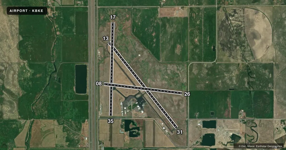
Airport sketch
Runways drawn to scale from FAA survey coordinates, rendered over satellite imagery. Not for navigation.
Approaches & charts
Services on the field
Fuel grades, oxygen, maintenance, ramp storage and lighting — as declared to the FAA by the airport operator.
Fuel & services
- Fuel
- 100LLA
- Oxygen (bottled)
- HIGH/LOW
- Oxygen (bulk)
- Not available
- Airframe repair
- Minor
- Power plant repair
- Major
- Other services
- CHTR,INSTR,RNTL,SALES
Ramp & ground
- Transient storage
- Tie-down
- Hangar
- Landing fee
- No fee published
- Customs
- Not available
- Lighting schedule
- SEE RMK
- Beacon schedule
- SS-SR
- Beacon
- White / Green (civil land)(WG)
- Wind indicator
- Lighted
- Segmented circle
- Yes
Fuel & FBOs
Cheapest 100LL and Jet A on the field and nearby. Always confirm with the FBO before taxi.
Airport notes
Surface conditions, obstructions, local procedures, lighting outages and other notes published with each FAA cycle.
General notes
- BIRDS INVOF APRT.
- COLD TEMP ARPT. ALT COR RQRD AT OR BLO -22C.
- RWY 8/26 CLSD INDEF.
Lighting notes
- ACTVT REIL RWY 13 & 31; MIRL RWY 13/31 - CTAF. VASI RWY 13 OPR CONSLY.
Approach & departure obstructions
- 35RWY 35 15 FT ROAD 110 FT FM RWY END.
- 08NO MRKGS.
- 35NO RWY NR.
- 35RWY 35 15 FT ROAD; DIST 110 FT; 14:1 BASED ON 397' DSPLCD THLD.
Other notes
- ESTABD PRIOR TO 15 MAY 1959.
- MANAGERALSO JOYCE BORNSTEDT(DIR. OF PUBLIC WORKS) 541-523-6541.
VFR map & nearby airports
VFR sectional. Tap any ICAO chip to open that airport.
Key facts · KBKE
Answer card- ICAO
- KBKE
- Name
- BAKER CITY MUNI
- Location
- BAKER CITY, OREGON
- Elevation
- 3,373.2 ft MSL
- Traffic pattern altitude
- 4,373.2 ft MSL (1,000 AGL)
- Control tower
- Non-towered (use CTAF)
- Total runways
- 3
- Longest runway
- 13/31 · 5,084 ft
- Published ILS approaches
- 0
- Published frequencies
- 2
- Magnetic variation
- 16°
- Current flight rules
- MVFR
- Current wind
- 000° at 0 kt
- Favored runway now
- –
Baker City Muni (KBKE) sits in Baker City, Oregon. The field elevation is 3,373.2 ft MSL. It has three asphalt runways. The longest is runway 13/31 at 5,084 ft. There is no control tower. CTAF and UNICOM are both 123.0. No ILS approaches are published.
Pattern altitude is not published. Use 1,000 ft AGL for light piston traffic unless the current FAA Chart Supplement says otherwise. That puts the standard pattern at about 4,373 ft MSL here. Baker Aircraft is on the field. It carries 100LL, Jet A and Jet A Prist. Call (541) 523-5663 for current service details.
There are a few items a first-time pilot should have in mind. Runway 8/26 is closed indefinitely. Runway 35 has a 15 ft road obstruction 110 ft from the runway end. The published clearance slope is 14 to 1 from a displaced threshold. Runway 13 and 31 have medium intensity lighting controlled by CTAF. Runway end identifier lights are also installed on those runways. The VASI for runway 13 operates continuously. Birds are reported in the area. This is a cold temperature airport. Use the published temperature correction at or below minus 22 C. Check the current FAA Chart Supplement for any local operating notes before you go.