METAR & TAF 9S9
Current METAR
Observed 16:15Z
K9S9 271615Z AUTO 00000KT 10SM CLR 22/09 A3010 RMK AO2
- Wind
- 000° @ 0 kt
- Visibility
- 10 SM
- Temp / Dew
- 22°C / 9°C
- Altimeter
- 30.10 inHg
- Clouds
- CLR
- Density alt
- 2,644 ft
- Ceiling
- Unlimited
- Rules
- VFR
Airport info & contacts
Manager on record, flight service, ARTCC, attendance schedule and pattern altitude — published by the FAA and refreshed every 28 days.
Location
- From city
- 1 NM N
- VFR sectional
- SEATTLE
- ARTCC
- ZSE · SEATTLE
- NOTAM facility
- MMV (NOTAM-D)
Airport manager
- Name
- ROSE KYLLO
- Phone
- 541-519-3803
- Address
- BOX 428, LEXINGTON OR 97839
Flight service · Hours
- FSS MMV
- MC MINNVILLE1-800-WX-BRIEF
- Attendance
- Unattended
Frequencies
Tap any row to copy the frequency to your clipboard.
Runways & pattern
Full pagePattern entry · RWY 08
LEFT TRAFFICRunway end performance
| End | TORA | TODA | ASDA | LDA | VGSI | Approach lights | Obstruction |
|---|---|---|---|---|---|---|---|
| 08 | — | — | — | — | PAPI 2-box left(3°) | — | 8', fence, 415' from thr, 0' R of cntrln, slope 26 |
| 26 | — | — | — | — | PAPI 2-box left(3.5°) | — | — |
Declared distances in feet. TORA = takeoff run available, TODA = takeoff distance, ASDA = accelerate-stop, LDA = landing distance.
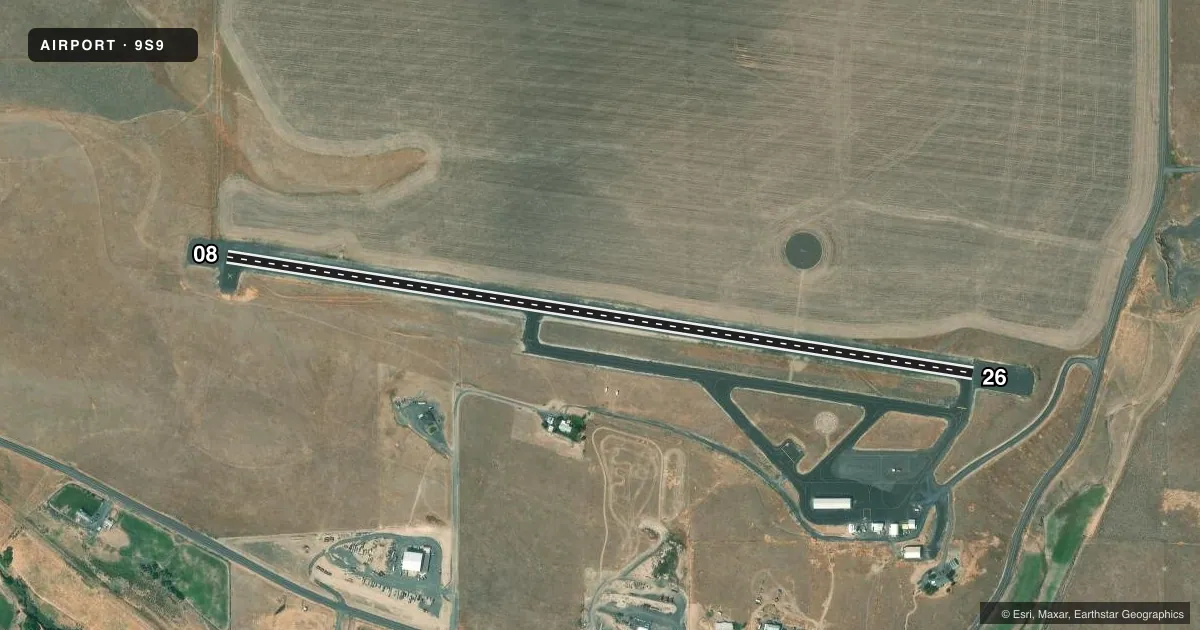
Airport sketch
Runways drawn to scale from FAA survey coordinates, rendered over satellite imagery. Not for navigation.
Approaches & charts
Services on the field
Fuel grades, oxygen, maintenance, ramp storage and lighting — as declared to the FAA by the airport operator.
Fuel & services
- Fuel
- 100LL
- Oxygen (bottled)
- Not available
- Oxygen (bulk)
- Not available
- Other services
- AGRI
Ramp & ground
- Transient storage
- Tie-down
- Landing fee
- No fee published
- Customs
- Not available
- Lighting schedule
- SEE RMK
- Beacon schedule
- SS-SR
- Beacon
- White / Green (civil land)(WG)
- Wind indicator
- Lighted
- Segmented circle
- Yes
Fuel & FBOs
Cheapest 100LL and Jet A on the field and nearby. Always confirm with the FBO before taxi.
Airport notes
Surface conditions, obstructions, local procedures, lighting outages and other notes published with each FAA cycle.
General notes
- SEASONAL HVY AG OPNS.
- WILDLIFE ON AND INVOF ARPT.
- FOR CD CTC SEATTLE ARTCC AT 253-351-3694.
Lighting notes
- ACTVT REIL RWY 08 & 26; PAPI RWY 08 & 26; MIRL RWY 08/26 - CTAF.
Fuel notes
- 100LLFUEL 24 HR CREDIT CARD SVC AVBL.
Runway surface & condition
- 08/26RWY 08/26 200 FT GRVL E END.
Approach & departure obstructions
- 0850:1 APCH BYD FENCE.
Other notes
- ARPT ESTABD PRIOR TO 1959.
VFR map & nearby airports
VFR sectional. Tap any ICAO chip to open that airport.
Key facts · 9S9
Answer card- ICAO
- 9S9
- Name
- LEXINGTON
- Location
- LEXINGTON, OREGON
- Elevation
- 1,634.5 ft MSL
- Traffic pattern altitude
- 2,634.5 ft MSL (1,000 AGL)
- Control tower
- Non-towered (use CTAF)
- Total runways
- 1
- Longest runway
- 08/26 · 4,156 ft
- Published ILS approaches
- 0
- Published frequencies
- 1
- Magnetic variation
- 17°
- Current flight rules
- VFR
- Current wind
- 000° at 0 kt
- Favored runway now
- –
Lexington Airport (9S9) sits in Lexington, Oregon at 1,634.5 ft MSL. It has one runway, 08/26, which is 4,156 ft long. The field is not towered. CTAF is 122.9. No ILS approaches are published here.
The pattern altitude is not published. Use the standard 1,000 ft AGL for light piston operations unless local guidance says otherwise. Lexington Airport has one on-field FBO, Lexington Airport, which carries AVGAS 100LL. Fuel is available 24 hours with credit card service.
A few published remarks matter for planning. Seasonal heavy agricultural traffic occurs. Wildlife is also on and near the airport. Runway 08 and 26 have runway end identifier lights and PAPI. Medium intensity runway lights are on runway 08/26 and are controlled by CTAF. Runway 08/26 also has 200 ft of gravel at the east end. There is a 50 to 1 approach slope beyond the fence at runway 08. For clearance delivery, contact Seattle ARTCC at 253-351-3694. This is a good field to brief carefully before arrival, especially if you are new to the area or flying in during ag activity.