METAR & TAF KDLS
Current METAR
Observed 12:53Z
KDLS 271253Z AUTO 23004KT 10SM CLR 16/09 A3003 RMK AO2 SLP169 T01560094
- Wind
- 230° @ 4 kt
- Visibility
- 10 SM
- Temp / Dew
- 16°C / 9°C
- Altimeter
- 30.03 inHg
- Clouds
- CLR
- Density alt
- 289 ft
- Ceiling
- Unlimited
- Rules
- VFR
Airport info & contacts
Manager on record, flight service, ARTCC, attendance schedule and pattern altitude — published by the FAA and refreshed every 28 days.
Location
- From city
- 2 NM NE
- VFR sectional
- SEATTLE
- ARTCC
- ZSE · SEATTLE
- NOTAM facility
- DLS (NOTAM-D)
Airport manager
- Name
- JEFF RENARD
- Phone
- 509-767-2272
- Address
- PO BOX 285, DALLES PORT WA 98617
Flight service · Hours
- FSS SEA
- SEATTLE1-800-WX-BRIEF
- Attendance
- 0800-1700
Frequencies
Tap any row to copy the frequency to your clipboard.
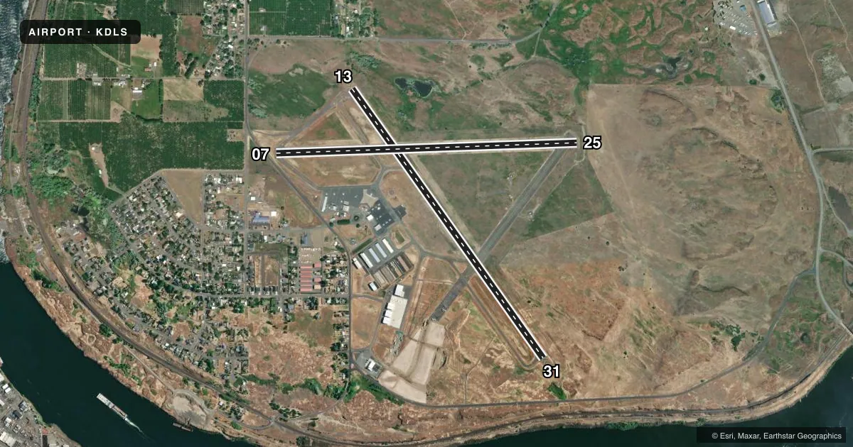
Runways & pattern
Full pagePattern entry · RWY 25
LEFT TRAFFIC| Runway | Heading (°M) | Length | Surface | Traffic |
|---|---|---|---|---|
| 13/31 | 130° / 310° | 5,097 ft | ASPH | Standard L |
| 07/25Favored | 73° / 253° | 4,647 ft | ASPH | Standard L |
Runway end performance
| End | TORA | TODA | ASDA | LDA | VGSI | Approach lights | Obstruction |
|---|---|---|---|---|---|---|---|
| 13 | — | — | — | — | — | — | 15', trees, 201' from thr, 107' R of cntrln, slope 0 |
| 07 | — | — | — | — | — | — | 34', pole, 796' from thr, 112' R of cntrln, slope 17 |
Declared distances in feet. TORA = takeoff run available, TODA = takeoff distance, ASDA = accelerate-stop, LDA = landing distance.
Airport sketch
Runways drawn to scale from FAA survey coordinates, rendered over satellite imagery. Not for navigation.
Approaches & charts
ILS · 1
Services on the field
Fuel grades, oxygen, maintenance, ramp storage and lighting — as declared to the FAA by the airport operator.
Fuel & services
- Fuel
- 100LLA1
- Oxygen (bottled)
- Not available
- Oxygen (bulk)
- Not available
- Airframe repair
- Major
- Power plant repair
- Major
- Other services
- AGRI,INSTR,RNTL
Ramp & ground
- Transient storage
- Tie-down
- Landing fee
- No fee published
- Customs
- Not available
- Lighting schedule
- SEE RMK
- Beacon schedule
- SS-SR
- Beacon
- White / Green (civil land)(WG)
- Wind indicator
- Lighted
- Segmented circle
- Yes
Fuel & FBOs
Cheapest 100LL and Jet A on the field and nearby. Always confirm with the FBO before taxi.
Airport notes
Surface conditions, obstructions, local procedures, lighting outages and other notes published with each FAA cycle.
General notes
- MTNS BYD 5000' APCH RY 31.
- ALL TWYS MARKED WITH REFLECTORS.
- WATERFOWL ON AND INVOF ARPT.
- PRIOR PERMISSION REQUIRED FOR OVERWEIGHT LNDGS.
- FOR CD CTC SEATTLE ARTCC AT 253-351-3694.
Lighting notes
- ACTVT MIRL RYS 13/31 & 07/25, & REIL RY 31 - CTAF. REIL OPERATES ON 7 CLICKS ONLY.
Approach & departure obstructions
- 07RWY 07 +15 FTROAD, 0 FT FM END, 200 FT R.
- 07RWY 07 , SLP 39:1 TO DTHR.
- 13CNTLG OBSTN EXCEEDS 45 DEG SLP.
- 25THLD DSPLCD TO PROVIDE SAFETY AREA.
Other notes
- ESTABD PRIOR TO 1959.
- MANAGERADNL CTC - 541-288-6766. MANAGER@FLYCGRA.COM.
VFR map & nearby airports
VFR sectional. Tap any ICAO chip to open that airport.
Key facts · KDLS
Answer card- ICAO
- KDLS
- Name
- COLUMBIA GORGE RGNL/THE DALLES MUNI
- Location
- THE DALLES, OREGON
- Elevation
- 246.5 ft MSL
- Traffic pattern altitude
- 1,246.5 ft MSL (1,000 AGL)
- Control tower
- Non-towered (use CTAF)
- Total runways
- 2
- Longest runway
- 13/31 · 5,097 ft
- Published ILS approaches
- 1
- Published frequencies
- 2
- Magnetic variation
- 15°
- Current flight rules
- VFR
- Current wind
- 230° at 4 kt
- Favored runway now
- RWY 25
Columbia Gorge Rgnl / The Dalles Muni sits in The Dalles, Oregon. Field elevation is 246.5 ft MSL. The airport has two asphalt runways. The longest is 5,097 ft on runway 13/31. There is no control tower. CTAF and UNICOM are both 123.0.
Runway 25 has the published ILS approach. Pattern altitude is not published, so use standard 1,000 ft AGL unless the current Chart Supplement says otherwise. Hood Aero is on the field. It carries 100LL, Jet A and Jet A Prist. Call them at (509) 767-0005 for current service details.
A few remarks matter here. Runway 07 has a road close off the end on the right side. Runway 25 has a displaced threshold for safety area. Runway 13 has a controlling obstruction near the approach path. Mountains are beyond 5,000 ft on approach to runway 31. Waterfowl are reported on and near the airport. Runway lights are medium intensity on both runways. REILs are on runway 31 and are CTAF controlled with 7-click activation. This is an older field, established before 1959. For clearance delivery, contact Seattle ARTCC. If you are bringing a heavier airplane, note that prior permission is required for overweight landings.