METAR & TAF 4S2
Current METAR
Observed 03:35Z
K4S2 270335Z AUTO 30003KT 10SM CLR 22/08 A3000 RMK AO2
- Wind
- 300° @ 3 kt
- Visibility
- 10 SM
- Temp / Dew
- 22°C / 8°C
- Altimeter
- 30.00 inHg
- Clouds
- CLR
- Density alt
- 1,532 ft
- Ceiling
- Unlimited
- Rules
- VFR
Airport info & contacts
Manager on record, flight service, ARTCC, attendance schedule and pattern altitude — published by the FAA and refreshed every 28 days.
Location
- From city
- 2 NM S
- VFR sectional
- SEATTLE
- Pattern altitude
- 869 ft AGL · 1,507 ft MSL
- ARTCC
- ZSE · SEATTLE
- NOTAM facility
- MMV (NOTAM-D)
Airport manager
- Name
- JEFF RENARD
- Phone
- 554-288-6766
- Address
- 3045 VALLEY VIEW DRIVE, THE DALLES OR 97058
Flight service · Hours
- FSS MMV
- MC MINNVILLE1-800-WX-BRIEF
- Attendance
- NOV-APR · 0800-1700
- MAY-OCT · 0800-1800
Frequencies
Tap any row to copy the frequency to your clipboard.
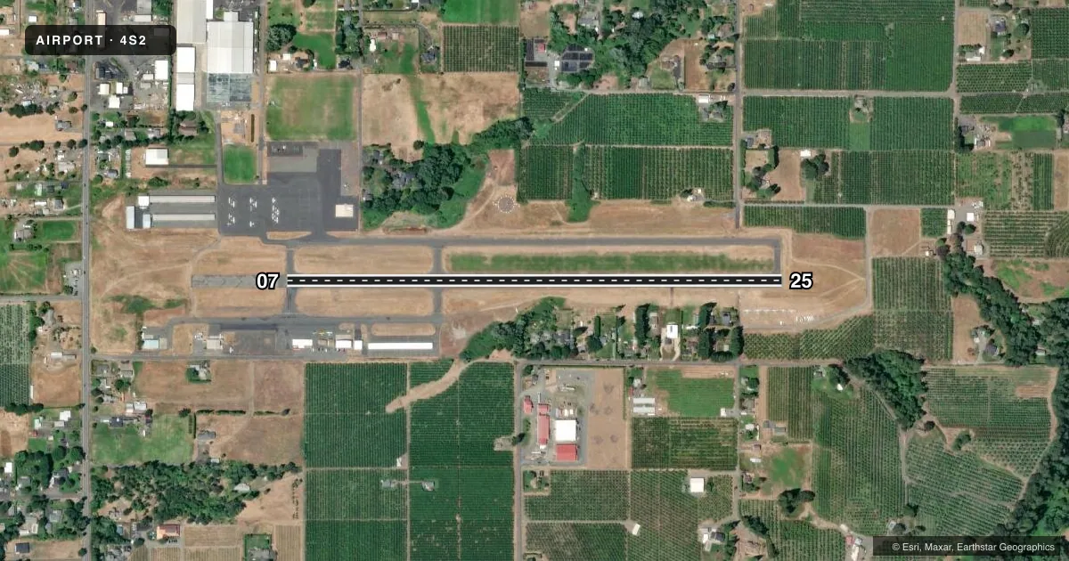
Runways & pattern
Full pagePattern entry · RWY 25
LEFT TRAFFICRunway end performance
| End | TORA | TODA | ASDA | LDA | VGSI | Approach lights | Obstruction |
|---|---|---|---|---|---|---|---|
| 07 | — | — | — | — | — | — | 86', tree, 1514' from thr, 225' R of cntrln, slope 15 |
| 25 | — | — | — | — | — | — | 50', tree, 980' from thr, 140' R of cntrln, slope 15 |
Declared distances in feet. TORA = takeoff run available, TODA = takeoff distance, ASDA = accelerate-stop, LDA = landing distance.
Airport sketch
Runways drawn to scale from FAA survey coordinates, rendered over satellite imagery. Not for navigation.
Approaches & charts
Services on the field
Fuel grades, oxygen, maintenance, ramp storage and lighting — as declared to the FAA by the airport operator.
Fuel & services
- Fuel
- 100LL
- Oxygen (bottled)
- Not available
- Oxygen (bulk)
- Not available
- Airframe repair
- Major
- Power plant repair
- Major
- Other services
- AGRI,GLD,INSTR,RNTL,TOW
Ramp & ground
- Transient storage
- Tie-down
- Landing fee
- No fee published
- Customs
- Not available
- Lighting schedule
- SEE RMK
- Beacon schedule
- SS-SR
- Beacon
- White / Green (civil land)(WG)
- Wind indicator
- Yes
- Segmented circle
- Yes
Fuel & FBOs
Cheapest 100LL and Jet A on the field and nearby. Always confirm with the FBO before taxi.
Airport notes
Surface conditions, obstructions, local procedures, lighting outages and other notes published with each FAA cycle.
General notes
- FREQUENT VEHICULAR TFC AER 7.
- BLUE EXIT LGTS AT 3 TURNOFFS.
- FOR CD CTC SEATTLE ARTCC AT 253-351-3694.
- HOOD RIVER ARPT IS A NOISE SENS AREA. PLS FLW THE FLY FRIENDLY SIGNS AT RWY ENDS AND AVOID LOW FLT.
Lighting notes
- ACTVT MIRL RY 07/25; REIL RWY 25 - CTAF.
Runway surface & condition
- 07/25GLDRS USE RP RWY 07/25. CROSSWINDS CAN PRODUCE EXTREME LOW LEVEL TURB & UNEXPCD WIND CURRENTS. TURF RWY AVBL IN GRASS MEDIAN NORTH OF PRIM RWY, NOT TO BE USED SIMUL WITH PAVED RWY.
Approach & departure obstructions
- 25CALM WIND RWY.
Other notes
- EST PRIOR TO 1959.
VFR map & nearby airports
VFR sectional. Tap any ICAO chip to open that airport.
Key facts · 4S2
Answer card- ICAO
- 4S2
- Name
- KEN JERNSTEDT AIRFIELD
- Location
- HOOD RIVER, OREGON
- Elevation
- 638 ft MSL
- Traffic pattern altitude
- 1,507 ft MSL (869 AGL)
- Control tower
- Non-towered (use CTAF)
- Total runways
- 1
- Longest runway
- 07/25 · 3,040 ft
- Published ILS approaches
- 0
- Published frequencies
- 2
- Magnetic variation
- 19°
- Current flight rules
- VFR
- Current wind
- 300° at 3 kt
- Favored runway now
- RWY 25
Ken Jernstedt Airfield sits in Hood River, Oregon. The field elevation is 638 ft MSL. It has one runway, 07/25, which is 3,040 ft long and paved with asphalt. The airport is non-towered. CTAF and UNICOM are both 122.8. No ILS approaches are published here.
Pattern altitude is 869 ft AGL. That is 1,507 ft MSL. Gliders use the right pattern on runway 07/25. Runway 25 is the calm wind runway. The published remarks also call this a noise sensitive area. Follow the Fly Friendly signs at the runway ends and avoid low flight over the airport. Crosswinds can bring strong low-level turbulence and wind shifts here, so plan your arrival with that in mind.
Hood Aero is on the field. It carries 100LL. The airport also has medium intensity runway lights on 07/25. Runway end identifier lights are on runway 25 and are controlled by CTAF. A turf runway exists in the grass median north of the paved runway. Do not use it at the same time as the paved runway. Clearance delivery is handled through Seattle ARTCC at 253-351-3694 when needed.