METAR & TAF W56
W56 does not publish a METAR.
Showing the nearest reporting station: KPDX (PORTLAND INTL) · 6.7 NM away. Conditions at W56 may differ.
METAR · KPDX
Observed 08:53Z
KPDX 270853Z 00000KT 10SM CLR 17/12 A3008 RMK AO2 SLP183 T01720122 51007 $
- Wind
- 000° @ 0 kt
- Visibility
- 10 SM
- Temp / Dew
- 17°C / 12°C
- Altimeter
- 30.08 inHg
- Clouds
- CLR
- Density alt
- 410 ft
- Ceiling
- Unlimited
- Rules
- VFR
Airport info & contacts
Manager on record, flight service, ARTCC, attendance schedule and pattern altitude — published by the FAA and refreshed every 28 days.
Location
- From city
- 4 NM NE
- VFR sectional
- SEATTLE
- ARTCC
- ZSE · SEATTLE
- NOTAM facility
- SEA (NOTAM-D)
Airport manager
- Name
- GEORGE MANLEY
- Phone
- 360-253-4850
- Address
- 8807 NE 142ND AVE, VANCOUVER WA 98682
Flight service · Hours
- FSS SEA
- SEATTLE1-800-WX-BRIEF
- Attendance
- Unattended
Frequencies
Tap any row to copy the frequency to your clipboard.
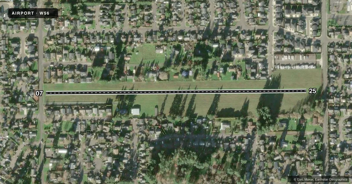
Runways & pattern
Full pagePattern entry · RWY 07
LEFT TRAFFICRunway end performance
| End | TORA | TODA | ASDA | LDA | VGSI | Approach lights | Obstruction |
|---|---|---|---|---|---|---|---|
| 07 | — | — | — | — | — | — | 30', pline, 170' from thr, 0' R of cntrln, slope 5 |
| 25 | — | — | — | — | — | — | 60', tree, 476' from thr, 0' R of cntrln, slope 7 |
Declared distances in feet. TORA = takeoff run available, TODA = takeoff distance, ASDA = accelerate-stop, LDA = landing distance.
Airport sketch
Runways drawn to scale from FAA survey coordinates, rendered over satellite imagery. Not for navigation.
Approaches & charts
Services on the field
Fuel grades, oxygen, maintenance, ramp storage and lighting — as declared to the FAA by the airport operator.
Fuel & services
- Fuel
- Not available
Ramp & ground
- Transient storage
- Tie-down
- Wind indicator
- Yes
- Segmented circle
- No
Fuel & FBOs
Cheapest 100LL and Jet A on the field and nearby. Always confirm with the FBO before taxi.
Airport notes
Surface conditions, obstructions, local procedures, lighting outages and other notes published with each FAA cycle.
General notes
- RY 07 CALM WIND RY FOR TKOF; RY 25 CALM WIND RY FOR LNDG.
- TAXI ON RY AND MOWED GRASS AREAS ONLY.
- FOR CD CTC PORTLAND APCH AT 503-493-7545.
Runway surface & condition
- 07/25RY EDGE MARKED WITH YELLOW REFLECTOR CONES.
Approach & departure obstructions
- 07ROAD AT RY END; 35 FT TREES AT 120 FT; 25 FT HOUSE AT 140 FT, 50 FT TREES AT 257 FT.
- 25ROAD CROSSES RY END. 22 FT HOUSE 240 FT FM RY END ON CL. 45 FT TREES 480 FT FROM RY END ON CL.
Other notes
- PILOTS BRING OWN TIEDOWNS.
- 1AIRPORT CLSD CHRISTMAS & EASTER.
VFR map & nearby airports
VFR sectional. Tap any ICAO chip to open that airport.
Key facts · W56
Answer card- ICAO
- W56
- Name
- FLY FOR FUN
- Location
- VANCOUVER, WASHINGTON
- Elevation
- 297 ft MSL
- Traffic pattern altitude
- 1,297 ft MSL (1,000 AGL)
- Control tower
- Non-towered (use CTAF)
- Total runways
- 1
- Longest runway
- 07/25 · 2,434 ft
- Published ILS approaches
- 0
- Published frequencies
- 1
- Magnetic variation
- 19°
- Current flight rules
- VFR
- Current wind
- 000° at 0 kt
- Favored runway now
- –
FLY FOR FUN (W56) sits in Vancouver, Washington. The field elevation is 297 ft MSL. It has one runway. Runway 07/25 is a 2,434 ft turf strip. There is no control tower. CTAF is 122.9. No ILS approaches are published here.
Pattern altitude is not published. Use the standard 1,000 ft AGL pattern unless the current Chart Supplement says otherwise. That puts you at about 1,297 ft MSL on a normal piston pattern. The airport sits near the Portland area, so expect to stay sharp on local traffic and clearances. For clearance delivery, Portland Approach is the published contact.
The published remarks matter here. Runway 07 is the calm wind runway for takeoff. Runway 25 is the calm wind runway for landing. Taxi is on the runway and mowed grass areas only. Pilots must bring their own tiedowns. The runway edge is marked with yellow reflector cones. The airport is closed on Christmas and Easter.
There are no on-field FBOs listed. Check with the airport operator or call the field on CTAF for current services before you go. The runway ends also have nearby roads and trees. That makes a careful short-field and obstacle-aware approach a good idea, especially on the turf surface.