METAR & TAF S20
S20 does not publish a METAR.
Showing the nearest reporting station: KDLS (COLUMBIA GORGE RGNL/THE DALLES MUNI) · 18.6 NM away. Conditions at S20 may differ.
METAR · KDLS
Observed 12:53Z
KDLS 271253Z AUTO 23004KT 10SM CLR 16/09 A3003 RMK AO2 SLP169 T01560094
- Wind
- 230° @ 4 kt
- Visibility
- 10 SM
- Temp / Dew
- 16°C / 9°C
- Altimeter
- 30.03 inHg
- Clouds
- CLR
- Density alt
- 2,064 ft
- Ceiling
- Unlimited
- Rules
- VFR
Airport info & contacts
Manager on record, flight service, ARTCC, attendance schedule and pattern altitude — published by the FAA and refreshed every 28 days.
Location
- From city
- 1 NM NW
- VFR sectional
- SEATTLE
- ARTCC
- ZSE · SEATTLE
- NOTAM facility
- SEA (NOTAM-D)
Airport manager
- Name
- RICHARD LUNDIN
- Phone
- 509-314-0564
- Address
- 1103 SOUTH COLUMBUS, P.O. BOX 69, GOLDENDALE WA 98620
Flight service · Hours
- FSS SEA
- SEATTLE1-800-WX-BRIEF
- Attendance
- Unattended
Frequencies
Tap any row to copy the frequency to your clipboard.
Runways & pattern
Full pagePattern entry · RWY 25
LEFT TRAFFICRunway end performance
| End | TORA | TODA | ASDA | LDA | VGSI | Approach lights | Obstruction |
|---|---|---|---|---|---|---|---|
| 07 | — | — | — | — | — | — | 15', gnd, 475' from thr, 0' R of cntrln, slope 18 |
| 25 | — | — | — | — | S2L 2-box left | — | 95', trees, 2573' from thr, 125' R of cntrln, slope 24 |
Declared distances in feet. TORA = takeoff run available, TODA = takeoff distance, ASDA = accelerate-stop, LDA = landing distance.
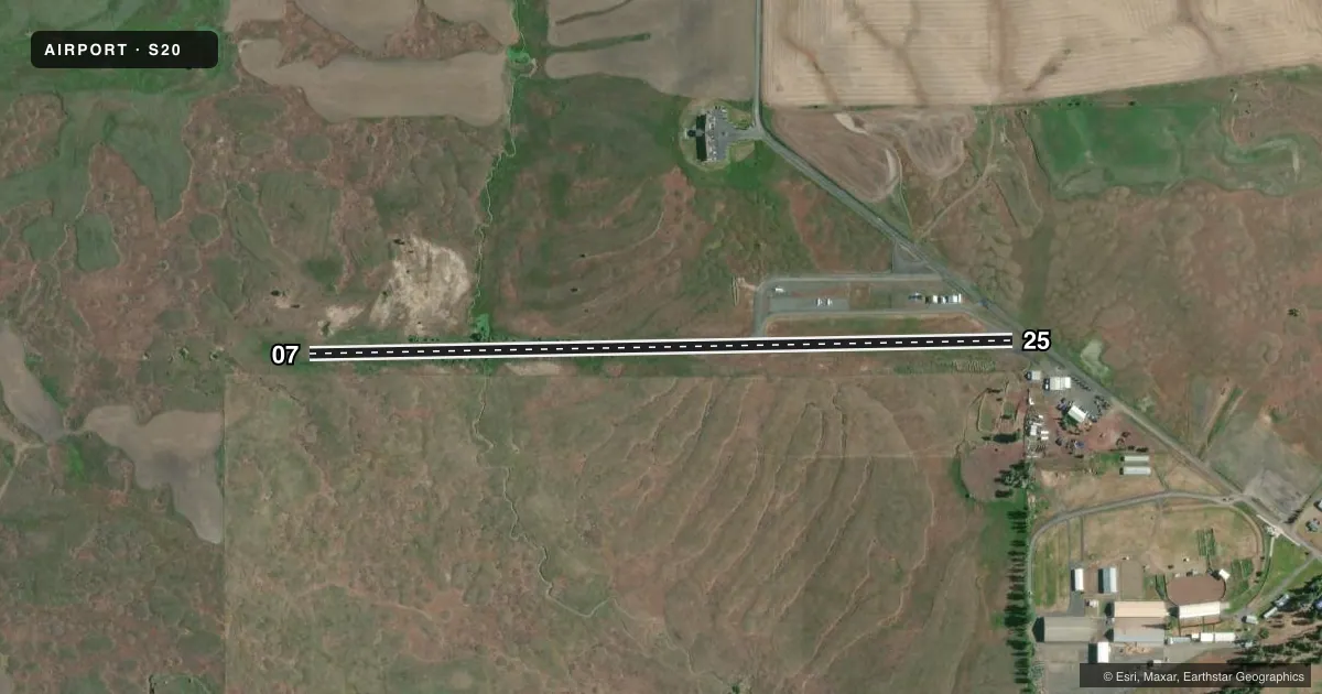
Airport sketch
Runways drawn to scale from FAA survey coordinates, rendered over satellite imagery. Not for navigation.
Approaches & charts
Services on the field
Fuel grades, oxygen, maintenance, ramp storage and lighting — as declared to the FAA by the airport operator.
Fuel & services
- Fuel
- 100LL
- Oxygen (bottled)
- Not available
- Oxygen (bulk)
- Not available
- Airframe repair
- Not available
- Power plant repair
- Not available
- Other services
- AGRI
Ramp & ground
- Transient storage
- Tie-down
- Landing fee
- No fee published
- Customs
- Not available
- Lighting schedule
- SEE RMK
- Beacon schedule
- SS-SR
- Beacon
- White / Green (civil land)(WG)
- Wind indicator
- Lighted
- Segmented circle
- No
Fuel & FBOs
Cheapest 100LL and Jet A on the field and nearby. Always confirm with the FBO before taxi.
Airport notes
Surface conditions, obstructions, local procedures, lighting outages and other notes published with each FAA cycle.
General notes
- FENCES, DITCH, BOULDERS, BLDGS & ROAD IN PRIMARY SURFACE.
- DEER AND WILDLIFE INVOF ARPT.
- FOR CD CTC SEATTLE ARTCC AT 253-351-3694.
- FUEL 24 HR CREDIT CARD SVC AVBL.
Lighting notes
- ACTIVATE MIRL RWY 07/25 - CTAF.
Approach & departure obstructions
- 074 FT FENCE 111 FT RIGHT & BOULDERS AT 0 FT & 80 FT RIGHT OF CNTRLN.
- 254 FT FENCE 65 FT, DITCH 67 FT, ROAD 81 FT FM THR AND FENCE AT 124 FT.
- 07NONSTD WHITE LINE CROSSES RWY NEAR RWY 7 MARKING.
- 25NONSTD WHITE LINE CROSSES RWY NEAR RWY 25 MARKING.
- 25RWY 25 APCH SLOPE 31:1 TO DSPLCD THLD.
Other notes
- ESTABD PRIOR TO 15 MAY 1959.
- PILOTS BRING OWN ROPES.
VFR map & nearby airports
VFR sectional. Tap any ICAO chip to open that airport.
Key facts · S20
Answer card- ICAO
- S20
- Name
- GOLDENDALE
- Location
- GOLDENDALE, WASHINGTON
- Elevation
- 1,678 ft MSL
- Traffic pattern altitude
- 2,678 ft MSL (1,000 AGL)
- Control tower
- Non-towered (use CTAF)
- Total runways
- 1
- Longest runway
- 07/25 · 3,491 ft
- Published ILS approaches
- 0
- Published frequencies
- 1
- Magnetic variation
- 19°
- Current flight rules
- VFR
- Current wind
- 230° at 4 kt
- Favored runway now
- RWY 25
Goldendale Airport sits in Goldendale, Washington at 1,678 ft MSL. It has one runway, 07/25, which is 3,491 ft long and asphalt. There is no control tower. CTAF is 122.9. No ILS approaches are published here. The pattern altitude is not published, so use the standard 1,000 ft AGL for light piston traffic unless the current Chart Supplement says otherwise.
Goldendale Airport has one on-field FBO, Goldendale Airport. It carries 100LL. Fuel is available with 24-hour credit card service. The field has a few things a first-time pilot should brief before arrival. Deer and wildlife are reported in the area. There are fences, a ditch, boulders, buildings and a road in the primary surface. Runway 25 has a displaced threshold and a steep approach slope to that threshold. A nonstandard white line also crosses the runway near each end. Medium intensity runway lights on 07/25 are activated via CTAF. For clearance delivery, contact Seattle ARTCC at 253-351-3694. Pilots should also bring their own ropes. Check the current FAA Chart Supplement and brief the runway environment before you go.