METAR & TAF 72S
72S does not publish a METAR.
Showing the nearest reporting station: KGEG (SPOKANE INTL) · 23.4 NM away. Conditions at 72S may differ.
METAR · KGEG
Observed 14:53Z
KGEG 271453Z 15007KT 8SM FEW045 FEW090 FEW150 17/04 A3007 RMK AO2 SLP168 FU FEW045 FU FEW090 FU HZ ALQDS T01670044 53014 $
- Wind
- 150° @ 7 kt
- Visibility
- 8 SM
- Temp / Dew
- 17°C / 4°C
- Altimeter
- 30.07 inHg
- Clouds
- FEW
- Density alt
- 2,745 ft
- Ceiling
- Unlimited
- Rules
- VFR
Airport info & contacts
Manager on record, flight service, ARTCC, attendance schedule and pattern altitude — published by the FAA and refreshed every 28 days.
Location
- From city
- 2 NM W
- VFR sectional
- SEATTLE
- ARTCC
- ZSE · SEATTLE
- NOTAM facility
- SEA (NOTAM-D)
Airport manager
- Name
- RYAN DIAMOND
- Phone
- 509-262-8054
- Address
- 223 N. WHITMAN AVE.S. SHORT RD, ROSALIA WA 99170
Flight service · Hours
- FSS SEA
- SEATTLE1-800-WX-BRIEF
- Attendance
- Unattended
Frequencies
Tap any row to copy the frequency to your clipboard.
Runways & pattern
Full pagePattern entry · RWY 20
RIGHT TRAFFICRunway end performance
| End | TORA | TODA | ASDA | LDA | VGSI | Approach lights | Obstruction |
|---|---|---|---|---|---|---|---|
| 02 | 2,807' | 2,807' | 2,670' | 2,505' | — | — | 58', tree, 1452' from thr, 25' R of cntrln, slope 25 |
| 20 | 2,807' | 2,807' | 2,642' | 2,505' | — | — | 13', road, 238' from thr, 0' R of cntrln, slope 2 |
Declared distances in feet. TORA = takeoff run available, TODA = takeoff distance, ASDA = accelerate-stop, LDA = landing distance.
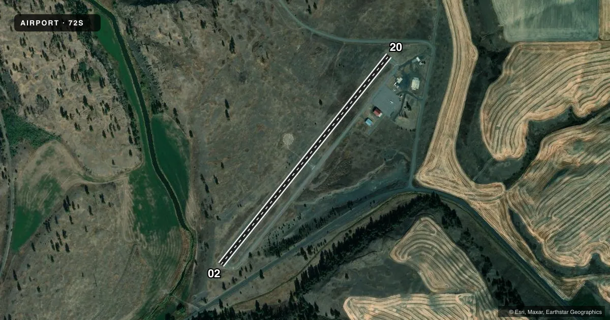
Airport sketch
Runways drawn to scale from FAA survey coordinates, rendered over satellite imagery. Not for navigation.
Approaches & charts
Services on the field
Fuel grades, oxygen, maintenance, ramp storage and lighting — as declared to the FAA by the airport operator.
Fuel & services
- Fuel
- Not available
- Other services
- AGRI
Ramp & ground
- Transient storage
- Tie-down
- Landing fee
- No fee published
- Customs
- Not available
- Lighting schedule
- SEE RMK
- Beacon schedule
- SS-SR
- Beacon
- White / Green (civil land)(WG)
- Wind indicator
- Yes
Fuel & FBOs
Cheapest 100LL and Jet A on the field and nearby. Always confirm with the FBO before taxi.
Airport notes
Surface conditions, obstructions, local procedures, lighting outages and other notes published with each FAA cycle.
General notes
- FOR CD CTC SPOKANE APCH AT 509-742-2522
Lighting notes
- ACTVT MIRL RWY 02/20 FREQ 122.9.
Runway surface & condition
- 02/20TAXIWAY REFLECTORS - NO TAXIWAY LGTS.
Approach & departure obstructions
- 023 FT BARBED WIRE FENCE 134 FT S OF RWY.
- 02120 FT TWRS & PLINES 1600 FT FROM RY 02 END.
Other notes
- ESTABD PRIOR TO 1959.
- PILOTS BRING OWN ROPES.
- MANAGERRYAN DIAMOND, ARPT EMERG CTC - 509-262-8054.
VFR map & nearby airports
VFR sectional. Tap any ICAO chip to open that airport.
Key facts · 72S
Answer card- ICAO
- 72S
- Name
- ROSALIA MUNI
- Location
- ROSALIA, WASHINGTON
- Elevation
- 2,170 ft MSL
- Traffic pattern altitude
- 3,170 ft MSL (1,000 AGL)
- Control tower
- Non-towered (use CTAF)
- Total runways
- 1
- Longest runway
- 02/20 · 2,807 ft
- Published ILS approaches
- 0
- Published frequencies
- 1
- Magnetic variation
- 19°
- Current flight rules
- VFR
- Current wind
- 150° at 7 kt
- Favored runway now
- RWY 20
Rosalia Muni sits in Rosalia, Washington. The field elevation is 2,170 ft MSL. It has one runway, 02/20, which is 2,807 ft long and paved. There is no control tower. CTAF is 122.9. No ILS approaches are published here.
The pattern altitude is not published. Use standard 1,000 ft AGL unless the current Chart Supplement says otherwise. That puts the light piston pattern at 3,170 ft MSL based on the field elevation, but verify before you fly. Medium intensity runway lights on 02/20 are activated on 122.9. Taxiway reflectors are installed. There are no taxiway lights.
No on-field FBOs are listed. Plan fuel and services with the airport operator or by calling the field directly before arrival. The published remarks also note that Spokane Approach handles clearance delivery. There is a 3 ft barbed wire fence 134 ft south of the runway. There are 120 ft towers and power lines 1,600 ft from the runway 02 end. Pilots should also note the remark that they must bring their own ropes. This is a small, non-towered field with terrain and obstacle awareness worth a close look before landing.