METAR & TAF 70S
70S does not publish a METAR.
Showing the nearest reporting station: KSFF (FELTS FLD) · 6.4 NM away. Conditions at 70S may differ.
METAR · KSFF
Observed 12:53Z
KSFF 271253Z 03003KT 9SM SCT055 16/06 A3004 RMK AO2 SLP158 T01560061 $
- Wind
- 030° @ 3 kt
- Visibility
- 9 SM
- Temp / Dew
- 16°C / 6°C
- Altimeter
- 30.04 inHg
- Clouds
- SCT
- Density alt
- 2,333 ft
- Ceiling
- Unlimited
- Rules
- VFR
Airport info & contacts
Manager on record, flight service, ARTCC, attendance schedule and pattern altitude — published by the FAA and refreshed every 28 days.
Location
- From city
- 1 NM N
- VFR sectional
- SEATTLE
- Pattern altitude
- 600 ft AGL · 2,505 ft MSL
- ARTCC
- ZSE · SEATTLE
- NOTAM facility
- SEA (NOTAM-D)
Airport manager
- Name
- DOUG KELLY
- Phone
- 253-880-7805
- Address
- 22304 72ND STREET EAST, BUCKLEY WA 98321
Flight service · Hours
- FSS SEA
- SEATTLE1-800-WX-BRIEF
- Attendance
- Unattended
Frequencies
Tap any row to copy the frequency to your clipboard.
Runways & pattern
Full pagePattern entry · RWY 34
LEFT TRAFFICRunway end performance
| End | TORA | TODA | ASDA | LDA | VGSI | Approach lights | Obstruction |
|---|---|---|---|---|---|---|---|
| 16 | — | — | — | — | — | — | 39', trees, 1470' from thr, 0' R of cntrln, slope 32 |
| 34 | — | — | — | — | — | — | 40', trees, 890' from thr, 0' R of cntrln, slope 17 |
Declared distances in feet. TORA = takeoff run available, TODA = takeoff distance, ASDA = accelerate-stop, LDA = landing distance.
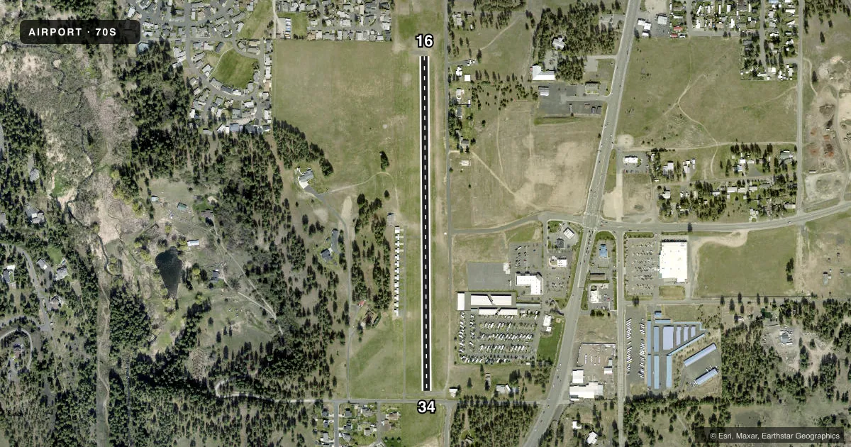
Airport sketch
Runways drawn to scale from FAA survey coordinates, rendered over satellite imagery. Not for navigation.
Approaches & charts
Services on the field
Fuel grades, oxygen, maintenance, ramp storage and lighting — as declared to the FAA by the airport operator.
Fuel & services
- Fuel
- Not available
- Oxygen (bottled)
- Not available
- Oxygen (bulk)
- Not available
- Airframe repair
- Not available
- Power plant repair
- Not available
Ramp & ground
- Transient storage
- Tie-down
- Landing fee
- No fee published
- Customs
- Not available
- Wind indicator
- Yes
- Segmented circle
- No
Fuel & FBOs
Cheapest 100LL and Jet A on the field and nearby. Always confirm with the FBO before taxi.
Airport notes
Surface conditions, obstructions, local procedures, lighting outages and other notes published with each FAA cycle.
General notes
- NO WINT MAINT.
- GND SOFT DURG SPRING.
- FOR CD CTC SPOKANE APCH AT 509-742-2522
Approach & departure obstructions
- 34+3 FT FENCE AT 65 FT, ROAD AT 74 FT AND 2 FT SLP 27 FT LEFT.
- 16RWY MARKINGS FADED.
- 34RWY MARKINGS FADED.
Other notes
- ESTABD PRIOR TO 15 MAY 1959.
VFR map & nearby airports
VFR sectional. Tap any ICAO chip to open that airport.
Key facts · 70S
Answer card- ICAO
- 70S
- Name
- MEAD FLYING SERVICE
- Location
- MEAD, WASHINGTON
- Elevation
- 1,905 ft MSL
- Traffic pattern altitude
- 2,505 ft MSL (600 AGL)
- Control tower
- Non-towered (use CTAF)
- Total runways
- 1
- Longest runway
- 16/34 · 2,481 ft
- Published ILS approaches
- 0
- Published frequencies
- 1
- Magnetic variation
- 19°
- Current flight rules
- VFR
- Current wind
- 030° at 3 kt
- Favored runway now
- RWY 34
Mead Flying Service Airport (70S) sits in Mead, Washington at 1,905 ft MSL. It has one runway. Runway 16/34 is 2,481 ft long with asphalt pavement. The field is not towered. CTAF is 122.9. Pattern altitude is 600 ft AGL, which is 2,505 ft MSL.
No ILS approaches are published here. Plan with that in mind if the weather is marginal. The published remarks also matter. Runway markings on both ends are faded. Runway 34 has a fence, a road and a small slope near the departure end. Ground can be soft during spring. There is no winter maintenance.
For clearance delivery, contact Spokane Approach at 509-742-2522. That is useful if you need help before departure or arrival. There are no on-field FBOs listed in the facts. Verify fuel and service options with the airport operator directly or call the field on CTAF before you go. The airport sits in a high-elevation part of eastern Washington. Expect density altitude to be a real factor on warm days. Check the current Chart Supplement for any noise or operational updates before flying in.