METAR & TAF KDEW
Current METAR
Observed 12:53Z
KDEW 271253Z AUTO 00000KT 10SM CLR 11/03 A3005 RMK AO2 SLP165 T01060033 $
- Wind
- 000° @ 0 kt
- Visibility
- 10 SM
- Temp / Dew
- 11°C / 3°C
- Altimeter
- 30.05 inHg
- Clouds
- CLR
- Density alt
- 2,100 ft
- Ceiling
- Unlimited
- Rules
- VFR
Airport info & contacts
Manager on record, flight service, ARTCC, attendance schedule and pattern altitude — published by the FAA and refreshed every 28 days.
Location
- From city
- 3 NM NE
- VFR sectional
- SEATTLE
- ARTCC
- ZSE · SEATTLE
- NOTAM facility
- DEW (NOTAM-D)
Airport manager
- Name
- DAROLD SCHULTZ
- Phone
- 509-276-3379
- Address
- PO BOX F, DEER PARK WA 99006
Flight service · Hours
- FSS SEA
- SEATTLE1-800-WX-BRIEF
- Attendance
- APR-OCT · 0800-1700
- NOV-MAR · 1000-1600
Frequencies
Tap any row to copy the frequency to your clipboard.
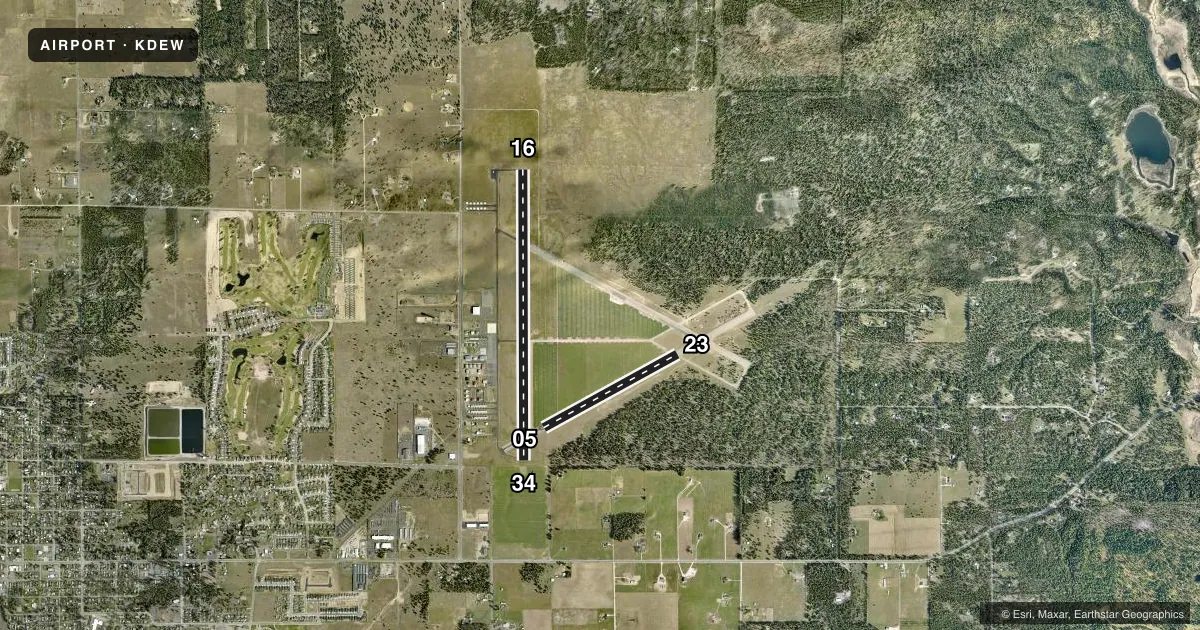
Runways & pattern
Full pagePattern entry · RWY 16
LEFT TRAFFIC| Runway | Heading (°M) | Length | Surface | Traffic |
|---|---|---|---|---|
| 16/34 | 164° / 344° | 6,101 ft | ASPH | Standard L |
| 05/23 | 45° / 225° | 3,200 ft | ASPH | Standard L |
Runway end performance
| End | TORA | TODA | ASDA | LDA | VGSI | Approach lights | Obstruction |
|---|---|---|---|---|---|---|---|
| 16 | — | — | — | — | PAPI 4-box left(3.5°) | — | 60', trees, 2900' from thr, 0' R of cntrln, slope 45 |
| 34 | — | — | — | — | PAPI 4-box left(3°) | — | — |
Declared distances in feet. TORA = takeoff run available, TODA = takeoff distance, ASDA = accelerate-stop, LDA = landing distance.
Airport sketch
Runways drawn to scale from FAA survey coordinates, rendered over satellite imagery. Not for navigation.
Approaches & charts
Services on the field
Fuel grades, oxygen, maintenance, ramp storage and lighting — as declared to the FAA by the airport operator.
Fuel & services
- Fuel
- 100LLA
- Oxygen (bottled)
- Not available
- Oxygen (bulk)
- Not available
- Airframe repair
- Major
- Power plant repair
- Major
- Other services
- GLD,INSTR,RNTL,TOW
Ramp & ground
- Transient storage
- Tie-down
- Landing fee
- No fee published
- Customs
- Not available
- Lighting schedule
- SEE RMK
- Beacon schedule
- SS-SR
- Beacon
- White / Green (civil land)(WG)
- Wind indicator
- Lighted
- Segmented circle
- Yes
Fuel & FBOs
Cheapest 100LL and Jet A on the field and nearby. Always confirm with the FBO before taxi.
Airport notes
Surface conditions, obstructions, local procedures, lighting outages and other notes published with each FAA cycle.
General notes
- MODEL AIRPLANE ACTIVITY ON ARPT.
- COYOTES ON AND INVOF RUNWAYS.
- RY 05/23 HEAVY GLIDER ACTIVITY ON WEEKENDS.
- FARMING OPN ACTIVE ON LAND ADJACENT TO RYS.
- NOISE ABATEMENT PROCEDURES IN EFFECT CTC AMGR 509-276-3379.
- RY 16 PREFERRED CALM WIND RY.
- 175 FT TOWER 2000 FT W OF RY 16/34.
- MONITOR GLIDER TRAFFIC ON 123.3 ABOVE 5,000 FT MSL.
- FOR CD CTC SPOKANE APCH AT 509-742-2522
Lighting notes
- ACTVT REIL RWY 16 AND RWY 34; MIRL RWY 16/34 - CTAF. PAPI RWY 16 & 34 OPR CONSLY.
Fuel notes
- 100LL100LL AND JET A AVBL 24 HRS CREDIT CARD SELF SVC FACILITY. CALL AHEAD FOR FULL SVC, JET A SVC 509-276-3379.
Approach & departure obstructions
- 16RWY MRKGS FADED.
- 34RWY MRKGS FADED.
Other notes
- ESTABD PRIOR TO 1959.
- GLIDER PATTERN TPA 1000 FT.
- PILOTS BRING OWN ROPES.
- MANAGEREMAIL: DEERPARKAIRPORT@GMAIL.COM
- MANAGERCELL 509-999-5835.
VFR map & nearby airports
VFR sectional. Tap any ICAO chip to open that airport.
Key facts · KDEW
Answer card- ICAO
- KDEW
- Name
- DEER PARK
- Location
- DEER PARK, WASHINGTON
- Elevation
- 2,210.7 ft MSL
- Traffic pattern altitude
- 3,210.7 ft MSL (1,000 AGL)
- Control tower
- Non-towered (use CTAF)
- Total runways
- 2
- Longest runway
- 16/34 · 6,101 ft
- Published ILS approaches
- 0
- Published frequencies
- 4
- Magnetic variation
- 16°
- Current flight rules
- VFR
- Current wind
- 000° at 0 kt
- Favored runway now
- –
Deer Park Airport (KDEW) sits in Deer Park, Washington. The field elevation is 2,210.7 ft MSL. It has two asphalt runways. The longest is 6,101 ft. Runway 16 is the preferred calm wind runway. Runway markings on 16 and 34 are faded, so plan for a careful visual check on rollout and lineup.
There is no control tower. CTAF and UNICOM are both 123.0. Spokane Approach handles approach and departure work on 123.75 and 282.25. No ILS approaches are published. The pattern altitude is not published for the airport, so use the standard 1,000 ft AGL for light piston traffic unless the current Chart Supplement says otherwise. Glider traffic is active above 5,000 ft MSL on 123.3. Model airplane activity also occurs on the airport. Farming operations are active on land next to the runways.
Deer Park Airport has one on-field FBO. Deer Park Airport carries 100LL and Jet A Prist. 100LL and Jet A are available 24 hours through credit card self-service. Call the FBO directly for full service or Jet A service. Pilots should also bring their own ropes. For clearance delivery, contact Spokane Approach before departure. The airport sits in a higher-elevation part of eastern Washington, so density altitude and climb performance deserve a close look on warm days.