METAR & TAF 1S9
1S9 does not publish a METAR.
Showing the nearest reporting station: KDEW (DEER PARK) · 24.4 NM away. Conditions at 1S9 may differ.
METAR · KDEW
Observed 15:53Z
KDEW 271553Z AUTO 13005KT 10SM CLR 21/05 A3008 RMK AO2 SLP173 T02060050 $
- Wind
- 130° @ 5 kt
- Visibility
- 10 SM
- Temp / Dew
- 21°C / 5°C
- Altimeter
- 30.08 inHg
- Clouds
- CLR
- Density alt
- 3,106 ft
- Ceiling
- Unlimited
- Rules
- VFR
Airport info & contacts
Manager on record, flight service, ARTCC, attendance schedule and pattern altitude — published by the FAA and refreshed every 28 days.
Location
- VFR sectional
- SEATTLE
- ARTCC
- ZSE · SEATTLE
- NOTAM facility
- SEA (NOTAM-D)
Airport manager
- Name
- JOE MCLAUGHLIN
- Phone
- 469-601-0475
- Address
- 2419C INDIAN RIDGE ROAD, CHEWELAH WA 99109
Flight service · Hours
- FSS SEA
- SEATTLE1-800-WX-BRIEF
- Attendance
- Unattended
Frequencies
Tap any row to copy the frequency to your clipboard.
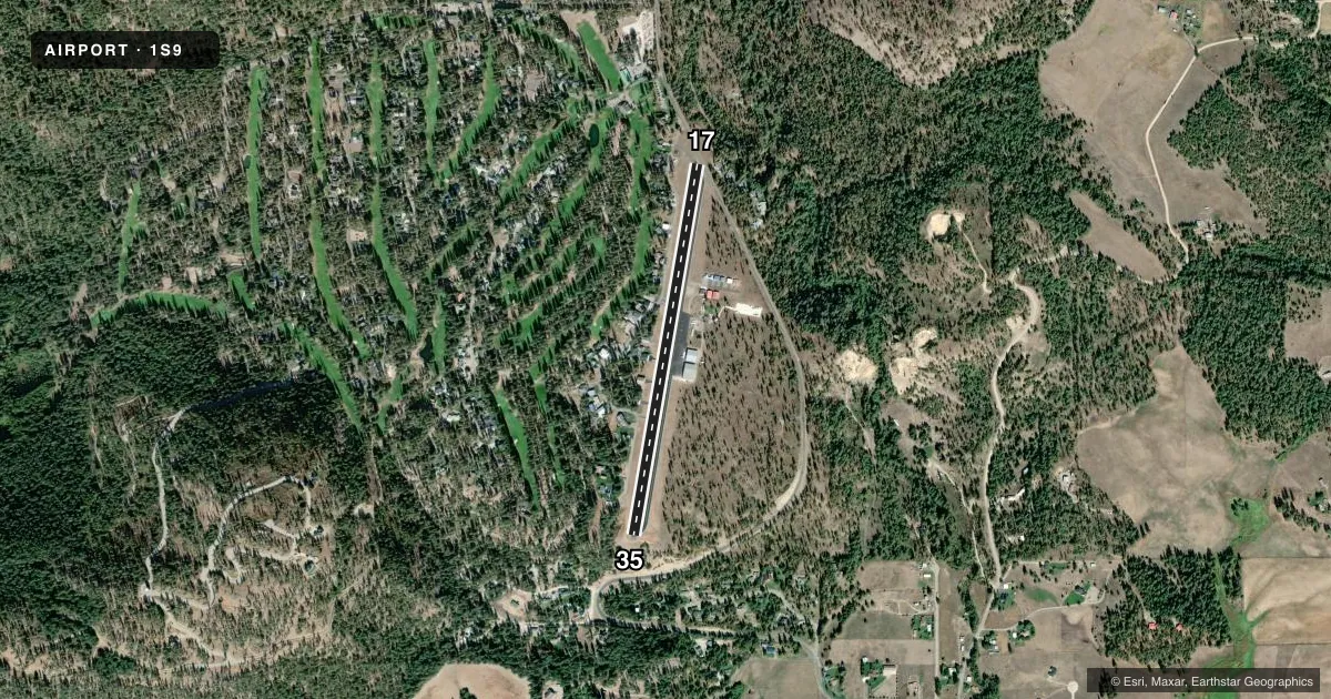
Runways & pattern
Full pagePattern entry · RWY 17
RIGHT TRAFFICRunway end performance
| End | TORA | TODA | ASDA | LDA | VGSI | Approach lights | Obstruction |
|---|---|---|---|---|---|---|---|
| 17 | — | — | — | — | PAPI 2-box right(4°) | — | 31', tree, 270' from thr, 10' R of cntrln, slope 2 |
| 35 | — | — | — | — | PAPI 2-box left(3°) | — | — |
Declared distances in feet. TORA = takeoff run available, TODA = takeoff distance, ASDA = accelerate-stop, LDA = landing distance.
Airport sketch
Runways drawn to scale from FAA survey coordinates, rendered over satellite imagery. Not for navigation.
Approaches & charts
Services on the field
Fuel grades, oxygen, maintenance, ramp storage and lighting — as declared to the FAA by the airport operator.
Fuel & services
- Fuel
- 100LLA
- Oxygen (bottled)
- Not available
- Oxygen (bulk)
- Not available
- Airframe repair
- Minor
- Power plant repair
- Minor
Ramp & ground
- Transient storage
- Tie-down
- Landing fee
- No fee published
- Lighting schedule
- SEE RMK
- Beacon schedule
- SS-SR
- Beacon
- White / Green (civil land)(WG)
- Wind indicator
- Lighted
- Segmented circle
- Yes
Fuel & FBOs
Cheapest 100LL and Jet A on the field and nearby. Always confirm with the FBO before taxi.
Airport notes
Surface conditions, obstructions, local procedures, lighting outages and other notes published with each FAA cycle.
General notes
- ALL PATTERNS TO THE WEST.
- DEER & WILDLIFE ON & INVOF ARPT.
- FOR CD CTC SEATTLE ARTCC AT 253-351-3694.
- LODGING & FOOD AVBL AT APRT.
Lighting notes
- ACTVT MIRL RY 17/35 - CTAF. PAPI RY 17 AND RY 35 OPER CONTINUOUSLY.
Fuel notes
- 100LL100LL & JET A AVBL 24 HRS CREDIT CARD SELF SVC.
Approach & departure obstructions
- 173 FT DITCH +1 FT TO +3 FT ROCKS & RD 56 FT FM THR; 77 FT L, +14 FT TREES 200 FT FM THR, AND 10 FT SIGN, 86 FT R, 53 FT FM THR.
- 17RWY 17 APCH SLOPE 50:1 TO DSPLCD THR.
Other notes
- PRVDD TREES ON APCH END OF RWY 17 ARE REMOVED OR RWY THR BE DSPLCD TO PRVD 20:1 OBSTN FREE APCH SFC 15' OVER SAND CANYON RD.
- PILOTS BRING OWN ROPES.
VFR map & nearby airports
VFR sectional. Tap any ICAO chip to open that airport.
Key facts · 1S9
Answer card- ICAO
- 1S9
- Name
- CHEWELAH MUNI
- Location
- CHEWELAH, WASHINGTON
- Elevation
- 2,084 ft MSL
- Traffic pattern altitude
- 3,084 ft MSL (1,000 AGL)
- Control tower
- Non-towered (use CTAF)
- Total runways
- 1
- Longest runway
- 17/35 · 3,537 ft
- Published ILS approaches
- 0
- Published frequencies
- 1
- Magnetic variation
- 20°
- Current flight rules
- VFR
- Current wind
- 130° at 5 kt
- Favored runway now
- RWY 17
Chewelah Muni sits in Chewelah, Washington at 2,084 ft MSL. It has one runway. Runway 17/35 is 3,537 ft long and paved with asphalt. There is no control tower. CTAF is 122.9. No ILS approaches are published here, so plan with the current chart and weather in mind before you go.
Pattern altitude is not published. Use 1,000 ft AGL for light piston traffic unless the current Chart Supplement or airport traffic advisories say otherwise. All traffic patterns are to the west. That matters here because the field has wildlife in the area. There are published obstructions near the approach end of runway 17. The runway 17 approach also has a displaced threshold note and a steep obstacle clearance note in the remarks, so review the current airport data before arrival.
Fuel is available on the field. The airport lists 100LL and Jet A with 24-hour credit card self-service. Lodging and food are also available at the airport. Runway lights on 17/35 are activated by CTAF. The PAPI on both runway ends operates continuously. For clearance delivery, contact Seattle ARTCC. If you are flying in for the first time, give yourself time to brief the west pattern, the terrain and obstruction notes and the wildlife risk on rollout and taxi.