METAR & TAF 09S
09S does not publish a METAR.
Showing the nearest reporting station: KSZT (SANDPOINT) · 43.4 NM away. Conditions at 09S may differ.
METAR · KSZT
Observed 15:55Z
KSZT 271555Z AUTO 18006KT 10SM CLR 22/06 A3007 RMK AO2
- Wind
- 180° @ 6 kt
- Visibility
- 10 SM
- Temp / Dew
- 22°C / 6°C
- Altimeter
- 30.07 inHg
- Clouds
- CLR
- Density alt
- 3,895 ft
- Ceiling
- Unlimited
- Rules
- VFR
Airport info & contacts
Manager on record, flight service, ARTCC, attendance schedule and pattern altitude — published by the FAA and refreshed every 28 days.
Location
- From city
- 3 NM SE
- VFR sectional
- SEATTLE
- ARTCC
- ZSE · SEATTLE
- NOTAM facility
- SEA (NOTAM-D)
Airport manager
- Name
- JOHN WILSON
- Phone
- 360-618-2477
- Address
- PO BOX 47312, OLYMPIA WA 98504-7264
Flight service · Hours
- FSS SEA
- SEATTLE1-800-WX-BRIEF
- Attendance
- Unattended
Frequencies
Tap any row to copy the frequency to your clipboard.
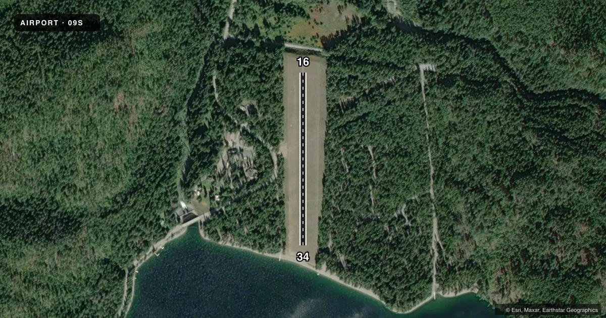
Runways & pattern
Full pagePattern entry · RWY 16
LEFT TRAFFICRunway end performance
| End | TORA | TODA | ASDA | LDA | VGSI | Approach lights | Obstruction |
|---|---|---|---|---|---|---|---|
| 16 | — | — | — | — | — | — | 200', trees, 1209' from thr, 125' R of cntrln, slope 6 |
| 34 | — | — | — | — | — | — | 25', sign, 212' from thr, 144' R of cntrln, slope 8 |
Declared distances in feet. TORA = takeoff run available, TODA = takeoff distance, ASDA = accelerate-stop, LDA = landing distance.
Airport sketch
Runways drawn to scale from FAA survey coordinates, rendered over satellite imagery. Not for navigation.
Approaches & charts
Services on the field
Fuel grades, oxygen, maintenance, ramp storage and lighting — as declared to the FAA by the airport operator.
Fuel & services
- Fuel
- Not available
- Oxygen (bottled)
- Not available
- Oxygen (bulk)
- Not available
- Airframe repair
- Not available
- Power plant repair
- Not available
Ramp & ground
- Transient storage
- Not published
- Landing fee
- No fee published
- Wind indicator
- Yes
- Segmented circle
- No
Fuel & FBOs
Cheapest 100LL and Jet A on the field and nearby. Always confirm with the FBO before taxi.
Airport notes
Surface conditions, obstructions, local procedures, lighting outages and other notes published with each FAA cycle.
General notes
- ARPT CLSD 1 OCT TO 1 JUN EXC FOR APPROVED MIL & PUBLIC SAFETY/LAW ENFORCEMENT HELI OPS.
- VEHICLES, PEDESTRIANS, AND ANIMALS ON AND INVOF ARPT.
- WATCH FOR GROUND SQUIRREL HOLES IN RY.
- FOR CD CTC SEATTLE ARTCC AT 253-351-3694.
Other notes
- EXISTED PRIOR TO 1959.
VFR map & nearby airports
VFR sectional. Tap any ICAO chip to open that airport.
Key facts · 09S
Answer card- ICAO
- 09S
- Name
- SULLIVAN LAKE STATE
- Location
- METALINE FALLS, WASHINGTON
- Elevation
- 2,614 ft MSL
- Traffic pattern altitude
- 3,614 ft MSL (1,000 AGL)
- Control tower
- Non-towered (use CTAF)
- Total runways
- 1
- Longest runway
- 16/34 · 1,765 ft
- Published ILS approaches
- 0
- Published frequencies
- 1
- Magnetic variation
- 20°
- Current flight rules
- VFR
- Current wind
- 180° at 6 kt
- Favored runway now
- RWY 16
Sullivan Lake State Airport sits near Metaline Falls, Washington. Field elevation is 2,614 ft MSL. It has one runway. Runway 16/34 is 1,765 ft long and turf. The airport is not towered. CTAF is 122.9. No ILS approaches are published. Pattern altitude is not published, so a light piston pilot should plan on the standard 1,000 ft AGL pattern unless the current FAA Chart Supplement says otherwise.
This field is seasonal. Published remarks say it is closed from October 1 to June 1 except for approved military and public safety or law enforcement helicopter operations. That matters for any trip planning. The remarks also call out ground squirrel holes on the runway. Vehicles, pedestrians and animals may be on or near the airport. That is worth a careful taxi and landing check.
There are no on-field FBOs listed. Plan on verifying services with the airport operator or the FBO directly by phone before you go. For clearance delivery, published remarks direct pilots to Seattle ARTCC at 253-351-3694. With the field sitting at 2,614 ft MSL, density altitude can matter on warm days. Check performance before departure. If you are filing or arriving VFR, use the current FAA Chart Supplement for any updates before you fly.