METAR & TAF 63S
Current METAR
Observed 22:35Z
K63S 262235Z VRB05G10KT 10SM CLR 29/07 A2995 RMK A01 PILOT CONTRLD LGHTING OUT OF SERVC- NOTAM 63S07/115. LIGHTS AVABL BY PRE-ARRNGMT
- Wind
- VAR @ 5G10 kt
- Visibility
- 10 SM
- Temp / Dew
- 29°C / 7°C
- Altimeter
- 29.95 inHg
- Clouds
- CLR
- Density alt
- 3,978 ft
- Ceiling
- Unlimited
- Rules
- VFR
Airport info & contacts
Manager on record, flight service, ARTCC, attendance schedule and pattern altitude — published by the FAA and refreshed every 28 days.
Location
- From city
- 1 NM E
- VFR sectional
- SEATTLE
- ARTCC
- ZSE · SEATTLE
- NOTAM facility
- SEA (NOTAM-D)
Airport manager
- Name
- DAVID GARRINGER
- Phone
- 509-685-9056
- Address
- 173-A N. AIRPORT DR, COLVILLE WA 99114
Flight service · Hours
- FSS SEA
- SEATTLE1-800-WX-BRIEF
- Attendance
- MON-FRI · 0800-1700
Frequencies
Tap any row to copy the frequency to your clipboard.
Runways & pattern
Full pagePattern entry · RWY 01
LEFT TRAFFICRunway end performance
| End | TORA | TODA | ASDA | LDA | VGSI | Approach lights | Obstruction |
|---|---|---|---|---|---|---|---|
| 19 | — | — | — | — | — | — | 61', tree, 249' from thr, 23' R of cntrln, slope 1 |
Declared distances in feet. TORA = takeoff run available, TODA = takeoff distance, ASDA = accelerate-stop, LDA = landing distance.
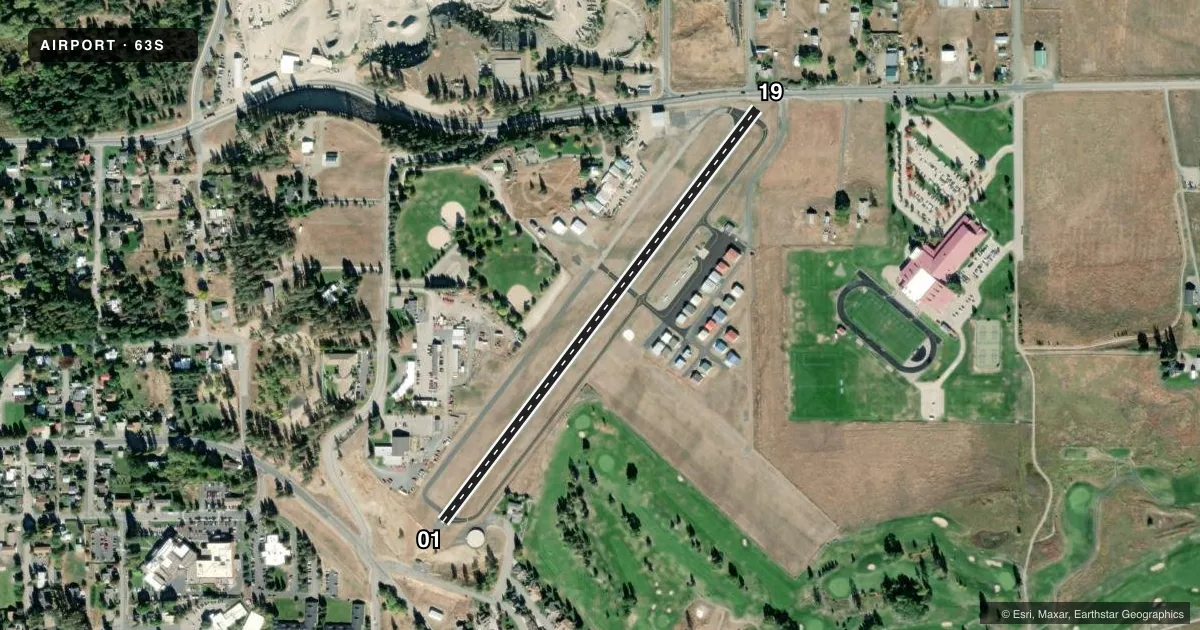
Airport sketch
Runways drawn to scale from FAA survey coordinates, rendered over satellite imagery. Not for navigation.
Approaches & charts
Services on the field
Fuel grades, oxygen, maintenance, ramp storage and lighting — as declared to the FAA by the airport operator.
Fuel & services
- Fuel
- 100LLA
- Other services
- INSTR
Ramp & ground
- Transient storage
- Tie-down
- Landing fee
- No fee published
- Customs
- Not available
- Lighting schedule
- SEE RMK
- Beacon schedule
- SS-SR
- Beacon
- White / Green (civil land)(WG)
- Wind indicator
- Yes
- Segmented circle
- No
Fuel & FBOs
Cheapest 100LL and Jet A on the field and nearby. Always confirm with the FBO before taxi.
Airport notes
Surface conditions, obstructions, local procedures, lighting outages and other notes published with each FAA cycle.
General notes
- WILDLIFE ON & INVOF OF ARPT.
- VEHICLE TFC ACRS RWY ENDS & TWY.
- 1500X150 FT GRASS LDG AREA ACRS RWY 01/19 HAS 50 FT TREES & POLES BOTH ENDS.
- FOR CD CTC SEATTLE ARTCC AT 253-351-3694.
Lighting notes
- ACTVT MIRL RWY 01/19 - CTAF.
Approach & departure obstructions
- 01RWY 01 6 FT FENCE AT END OF RWY, 113 RT FM RWY EDGE.
- 19RWY 19 8 FT FENCE AT 35 FT AND ROAD 66 FT FM THLD; BUILDING 170 FT FM THLD, 36 FT RIGHT.
- 19CTN: BRIGHT STADIUM LGTS 3/4 MI S.
- 19APCH RATIO 12:1; +50 FT TREE 300 FT FM DTHR 25 FT L.
Other notes
- ESTABD PRIOR TO 1959.
- MANAGER509-675-1041.
VFR map & nearby airports
VFR sectional. Tap any ICAO chip to open that airport.
Key facts · 63S
Answer card- ICAO
- 63S
- Name
- COLVILLE MUNI
- Location
- COLVILLE, WASHINGTON
- Elevation
- 1,883 ft MSL
- Traffic pattern altitude
- 2,883 ft MSL (1,000 AGL)
- Control tower
- Non-towered (use CTAF)
- Total runways
- 1
- Longest runway
- 01/19 · 2,691 ft
- Published ILS approaches
- 0
- Published frequencies
- 2
- Magnetic variation
- 20°
- Current flight rules
- VFR
- Current wind
- 000° at 5 kt
- Favored runway now
- RWY 01
Colville Muni sits in Colville, Washington at 1,883 ft MSL. It has one runway, 01/19, which is 2,691 ft long and asphalt. This is an uncontrolled field. CTAF and UNICOM are both 122.8. No ILS approaches are published here. The pattern altitude is not published, so use standard 1,000 ft AGL unless the current Chart Supplement says otherwise.
The on-field FBO is Colville Municipal Airport. It carries 100LL and Jet A with Prist. Call (509) 685-9056 for current service details before you go. Medium intensity runway lights on 01/19 are activated on CTAF. Published remarks also call out wildlife on and near the airport. Vehicle traffic crosses runway ends and taxiways, so keep your scan moving on the ground and in the pattern.
Runway 19 has several close-in obstructions near the threshold, including a fence, a road and a building off to the right. Runway 01 also has a fence near the end. There is also a grass landing area across 01/19 with trees and poles at both ends. For clearance delivery, Seattle ARTCC can be reached at 253-351-3694. The airport manager is listed at 509-675-1041. If you are planning a night or low-vis arrival, check the current Chart Supplement and brief the lighting and obstruction picture before departure.