METAR & TAF 69S
69S does not publish a METAR.
Showing the nearest reporting station: KOMK (OMAK) · 60.5 NM away. Conditions at 69S may differ.
METAR · KOMK
Observed 05:53Z
KOMK 270553Z AUTO 09004KT 9SM CLR 24/01 A2991 RMK AO2 SLP121 T02440011 10317 20244 51016
- Wind
- 090° @ 4 kt
- Visibility
- 9 SM
- Temp / Dew
- 24°C / 1°C
- Altimeter
- 29.91 inHg
- Clouds
- CLR
- Density alt
- 3,145 ft
- Ceiling
- Unlimited
- Rules
- VFR
Airport info & contacts
Manager on record, flight service, ARTCC, attendance schedule and pattern altitude — published by the FAA and refreshed every 28 days.
Location
- From city
- 2 NM SW
- VFR sectional
- SEATTLE
- ARTCC
- ZSE · SEATTLE
- NOTAM facility
- SEA (NOTAM-D)
Airport manager
- Name
- DAVE WHITELAW
- Phone
- 509-631-0623
- Address
- 807 SPRUCE STREET, RECREATIONAL AVIATION ASSOC, COULEE DAM WA 99116
Flight service · Hours
- FSS SEA
- SEATTLE1-800-WX-BRIEF
- Attendance
- Unattended
Frequencies
Tap any row to copy the frequency to your clipboard.
Runways & pattern
Full pagePattern entry · RWY 35
LEFT TRAFFICRunway end performance
| End | TORA | TODA | ASDA | LDA | VGSI | Approach lights | Obstruction |
|---|---|---|---|---|---|---|---|
| 17 | — | — | — | — | — | — | 39', trees, 96' from thr, 0' R of cntrln, slope 2 |
| 35 | — | — | — | — | — | — | 45', trees, 165' from thr, 0' R of cntrln, slope 3 |
Declared distances in feet. TORA = takeoff run available, TODA = takeoff distance, ASDA = accelerate-stop, LDA = landing distance.
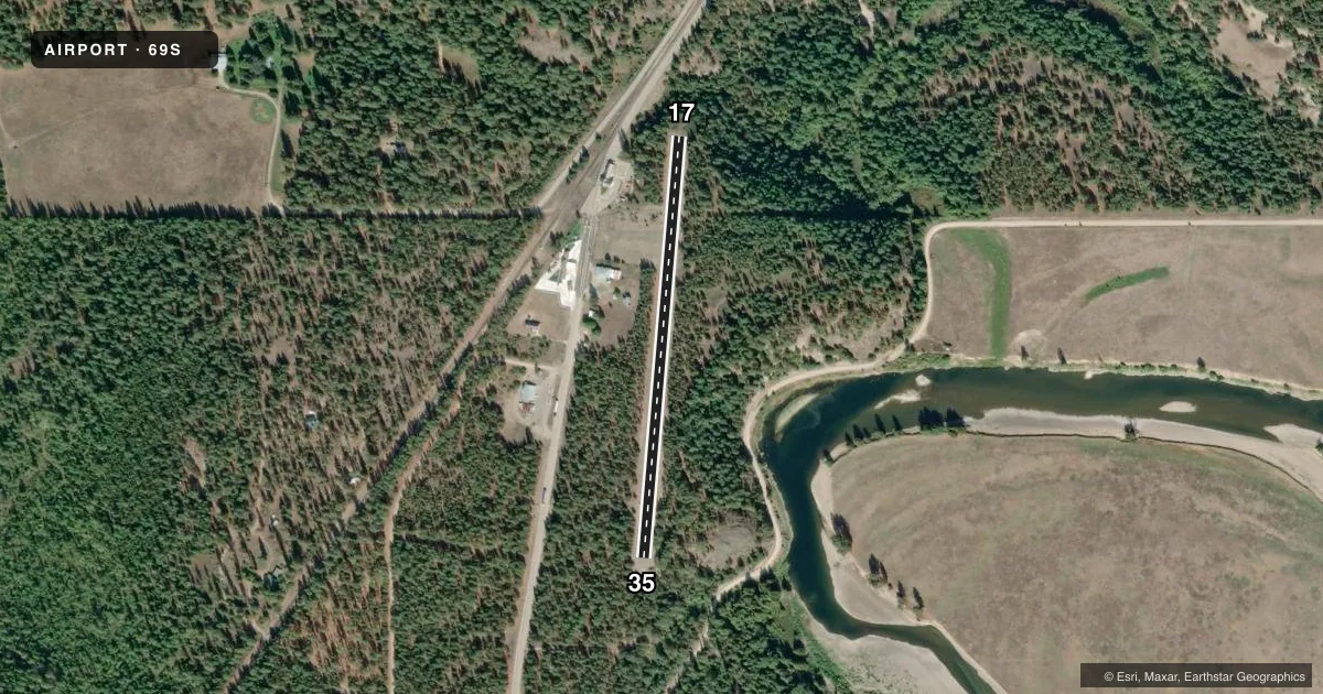
Airport sketch
Runways drawn to scale from FAA survey coordinates, rendered over satellite imagery. Not for navigation.
Approaches & charts
Services on the field
Fuel grades, oxygen, maintenance, ramp storage and lighting — as declared to the FAA by the airport operator.
Fuel & services
- Fuel
- Not available
- Airframe repair
- Not available
- Power plant repair
- Not available
Ramp & ground
- Transient storage
- Not published
- Landing fee
- No fee published
- Customs
- Not available
- Wind indicator
- No
- Segmented circle
- No
Fuel & FBOs
Cheapest 100LL and Jet A on the field and nearby. Always confirm with the FBO before taxi.
Airport notes
Surface conditions, obstructions, local procedures, lighting outages and other notes published with each FAA cycle.
General notes
- VEHICLES AND ANIMALS ON & INVOF RY.
- SHOULDERS VERY SOFT AND ROUGH BOTH SIDES OF RY.
- DENSITY ALTITUDE.
- CANADIAN AND U.S. CUSTOMS AVAILABLE ON HWY TO THE WEST.
- UNITED STATES BASED AIRCRAFT SHOULD PARK ON U.S. SIDE OF RAMP (SOUTH) AND CANADIAN BASED AIRCRAFT SHOULD PARK ON NORTH SIDE OF RAMP.
- HELICOPTER OPERATIONS ON AIRPORT DURING FIRE SEASON.
- FOR CD CTC SEATTLE ARTCC AT 253-351-3694.
- BLDG IN PRI SFC, SLP BOTH SIDES OF RWY, AND STEEP DROP OFF AT RWY ENDS.
Runway surface & condition
- 17/35TREES & FENCES IN PRIM SFC.
Approach & departure obstructions
- 17RWY MKD WITH RETRO-REFLECTIVE DEVICES.
Other notes
- MANAGERFOR ACFT ACCIDENTS/INCIDENTS CTC STATE EMERGENCY OPERATIONS CENTER @ 800-258-5990 AND MANAGER DAVE WHITELAW @ 509-603-0623.
VFR map & nearby airports
VFR sectional. Tap any ICAO chip to open that airport.
Key facts · 69S
Answer card- ICAO
- 69S
- Name
- AVEY FLD
- Location
- LAURIER, WASHINGTON
- Elevation
- 1,655 ft MSL
- Traffic pattern altitude
- 2,655 ft MSL (1,000 AGL)
- Control tower
- Non-towered (use CTAF)
- Total runways
- 1
- Longest runway
- 17/35 · 1,975 ft
- Published ILS approaches
- 0
- Published frequencies
- 1
- Magnetic variation
- 20°
- Current flight rules
- VFR
- Current wind
- 090° at 4 kt
- Favored runway now
- RWY 35
AVEY FLD is in Laurier, Washington. The field elevation is 1,655 ft MSL. It has one runway, 17/35, which is 1,975 ft long and gravel. There is no control tower. CTAF is 122.9. No ILS approaches are published.
The pattern altitude is not published. Use the standard 1,000 ft AGL pattern unless the current Chart Supplement says otherwise. That puts the light piston pattern at 2,655 ft MSL. The runway headings are magnetic, with 17/35 aligned about 185°/5°. The airport sits near the U.S.-Canada border. The remarks say U.S.-based aircraft should park on the south side of the ramp. Canadian-based aircraft should park on the north side.
This is a field to treat with care. The published remarks call out a building in the primary surface. They also call out a steep drop off at the runway ends, trees and fences in the primary surface, very soft and rough shoulders, vehicles and animals near the runway and helicopter activity during fire season. Density altitude is also a concern at this elevation. There are no on-field FBOs listed. For customs, the remarks say Canadian and United States customs are available on the highway to the west. For clearance delivery, contact Seattle ARTCC at 253-351-3694.