METAR & TAF 1WA
1WA does not publish a METAR.
Showing the nearest reporting station: CYYF (PENTICTON) · 30.2 NM away. Conditions at 1WA may differ.
METAR · CYYF
Observed 06:00Z
CYYF 270600Z 32004KT 15SM BKN110 22/08 A2994 RMK AC6 SLP134 DENSITY ALT 2300FT
- Wind
- 320° @ 4 kt
- Visibility
- 15 SM
- Temp / Dew
- 22°C / 8°C
- Altimeter
- 29.94 inHg
- Clouds
- BKN
- Density alt
- 1,950 ft
- Ceiling
- 11,000 ft AGL
- Rules
- VFR
Airport info & contacts
Manager on record, flight service, ARTCC, attendance schedule and pattern altitude — published by the FAA and refreshed every 28 days.
Location
- From city
- 2 NM N
- VFR sectional
- SEATTLE
- ARTCC
- ZSE · SEATTLE
- NOTAM facility
- SEA (NOTAM-D)
Airport manager
- Name
- CITY OF OROVILLE
- Phone
- 509-476-2926
- Address
- PO BOX 2200, OROVILLE WA 98844
Flight service · Hours
- FSS SEA
- SEATTLE1-800-WX-BRIEF
Frequencies
Tap any row to copy the frequency to your clipboard.
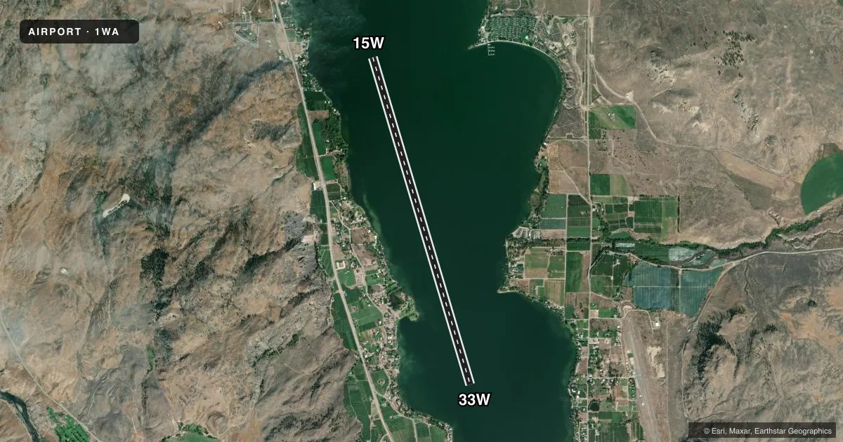
Runways & pattern
Full pagePattern entry · RWY 33W
RIGHT TRAFFICAirport sketch
Runways drawn to scale from FAA survey coordinates, rendered over satellite imagery. Not for navigation.
Approaches & charts
Services on the field
Fuel grades, oxygen, maintenance, ramp storage and lighting — as declared to the FAA by the airport operator.
Fuel & services
- Fuel
- Not available
Ramp & ground
- Transient storage
- Not published
Fuel & FBOs
Cheapest 100LL and Jet A on the field and nearby. Always confirm with the FBO before taxi.
Airport notes
Surface conditions, obstructions, local procedures, lighting outages and other notes published with each FAA cycle.
Other notes
- MANAGERSTEVE THOMPSON.
VFR map & nearby airports
VFR sectional. Tap any ICAO chip to open that airport.
Key facts · 1WA
Answer card- ICAO
- 1WA
- Name
- SCOTT
- Location
- OROVILLE, WASHINGTON
- Elevation
- 915 ft MSL
- Traffic pattern altitude
- 1,915 ft MSL (1,000 AGL)
- Control tower
- Non-towered (use CTAF)
- Total runways
- 1
- Longest runway
- 15W/33W · 10,000 ft
- Published ILS approaches
- 0
- Published frequencies
- 1
- Magnetic variation
- –
- Current flight rules
- VFR
- Current wind
- 320° at 4 kt
- Favored runway now
- RWY 33W
SCOTT (1WA) sits in Oroville, Washington. Field elevation is 915 ft MSL. The airport has one runway. It is runway 15W/33W on water. The longest published landing area is 10,000 ft. There is no control tower. CTAF is 122.9.
No ILS approaches are published here. Pattern altitude is not published. Plan on checking the current Chart Supplement before you go. The airport is a water strip, so the main planning item is making sure your aircraft and crew are set up for a water landing. The published remarks list Steve Thompson as the airport manager. No on-field FBOs are listed. Verify services with the airport operator or call the field on CTAF before arrival.
For a first-time arrival, treat this as a non-towered water airport with no published ILS backup. That means your arrival planning should be conservative. Confirm local traffic, weather and water conditions before committing. If you need current operational details, use the current FAA Chart Supplement or contact the airport operator directly.