METAR & TAF S52
Current METAR
Observed 11:15Z
KS52 271115Z AUTO 00000KT 10SM CLR 16/08 A2999 RMK AO2 T01600080
- Wind
- 000° @ 0 kt
- Visibility
- 10 SM
- Temp / Dew
- 16°C / 8°C
- Altimeter
- 29.99 inHg
- Clouds
- CLR
- Density alt
- 2,149 ft
- Ceiling
- Unlimited
- Rules
- VFR
Airport info & contacts
Manager on record, flight service, ARTCC, attendance schedule and pattern altitude — published by the FAA and refreshed every 28 days.
Location
- From city
- 3 NM SE
- VFR sectional
- SEATTLE
- ARTCC
- ZSE · SEATTLE
- NOTAM facility
- SEA (NOTAM-D)
Airport manager
- Name
- JOHN WILSON
- Phone
- 360-618-2477
- Address
- PO BOX 47312, OLYMPIA WA 98504-7264
Flight service · Hours
- FSS SEA
- SEATTLE1-800-WX-BRIEF
- Attendance
- Unattended
Frequencies
Tap any row to copy the frequency to your clipboard.
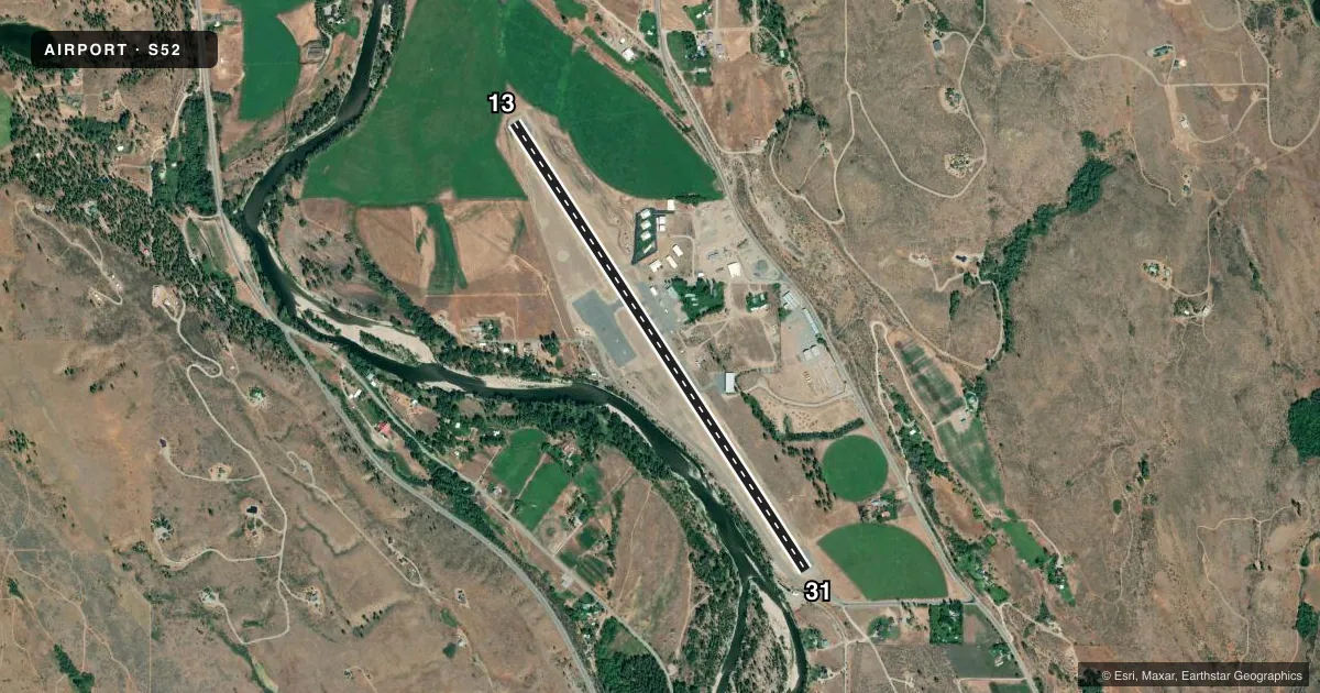
Runways & pattern
Full pagePattern entry · RWY 13
LEFT TRAFFICRunway end performance
| End | TORA | TODA | ASDA | LDA | VGSI | Approach lights | Obstruction |
|---|---|---|---|---|---|---|---|
| 13 | 5,049' | 5,049' | 4,749' | 4,619' | PAPI 2-box left(3.5°) | — | 4', other, 200' from thr, 175' R of cntrln, slope 0 |
| 31 | 5,049' | 5,049' | 4,919' | 4,619' | — | — | 39', trees, 538' from thr, 33' R of cntrln, slope 9 |
Declared distances in feet. TORA = takeoff run available, TODA = takeoff distance, ASDA = accelerate-stop, LDA = landing distance.
Airport sketch
Runways drawn to scale from FAA survey coordinates, rendered over satellite imagery. Not for navigation.
Approaches & charts
Services on the field
Fuel grades, oxygen, maintenance, ramp storage and lighting — as declared to the FAA by the airport operator.
Fuel & services
- Fuel
- 100LLA
- Oxygen (bottled)
- Not available
- Oxygen (bulk)
- Not available
- Airframe repair
- Not available
- Power plant repair
- Not available
Ramp & ground
- Transient storage
- Tie-down
- Landing fee
- No fee published
- Customs
- Not available
- Lighting schedule
- SEE RMK
- Beacon schedule
- SEE RMK
- Beacon
- White / Green (civil land)(WG)
- Wind indicator
- Yes
- Segmented circle
- Yes
Fuel & FBOs
Cheapest 100LL and Jet A on the field and nearby. Always confirm with the FBO before taxi.
Airport notes
Surface conditions, obstructions, local procedures, lighting outages and other notes published with each FAA cycle.
General notes
- SOME OBSTNS IN PRIMARY AND TRANSITIONAL SFCS.
- PEDESTRIANS, VEHICLES, AND ANIMALS ON AND INVOF RY.
- SMOKE JUMPER BASE PRCHT OPS COMMON DURG SPRING AND SUMMER MONTHS.
Lighting notes
- ROTG BCN PCL - CTAF.
- ACTVT MIRL RY 13/31 - CTAF.
Approach & departure obstructions
- 13ROAD AT 0 FT.
- 31ROAD 0 FT, 125 FT L, ROAD 182 FT, +5 FT STEEL POST & FENCE AT 78 FT, 80 FT L.
- 13IRRIGATION CENTER PIVOT. DISTANCE FROM END VARIES FROM 200 FEET TO 280 FEET FROM RY END. DISTANCE FROM THRESHOLD VARIES FROM 330 FEET TO 410 FEET.
- 31MULTIPLE TREES. DISTANCE FROM END VARIES FROM 425 TO 730 FEET FROM RY END. DISTANCE FROM THRESHOLD 725 FEET TO 1030 FEET.
- 13CENTER PIVOT IRRIGATION. RWY 13 APCH SLOPE 0:1 TO +13' SERVICE ROAD @ 0', 92' R FROM DSPLCD THR.
- 31RWY 31 APCH SLOPE TO DSPLCD +65 FT TREE 538 FT FM THLD, 39 FT RIGHT OF CENTERLINE.
- 13CENTER PIVOT.
- 31MOST RESTRICTIVE TREE.
- 13AGRI-IRRIGATION SYSTEM
Other notes
- PILOTS PROVD OWN CHAINS FOR TIEDOWN.
- USDA FOREST SVC SMOKE JUMP BASE UNICOM. LTD ADVISORIES RELATED TO BASE OPS MOSTLY DURING SUMMER FIRE SEASON.
VFR map & nearby airports
VFR sectional. Tap any ICAO chip to open that airport.
Key facts · S52
Answer card- ICAO
- S52
- Name
- METHOW VALLEY STATE
- Location
- WINTHROP, WASHINGTON
- Elevation
- 1,706 ft MSL
- Traffic pattern altitude
- 2,706 ft MSL (1,000 AGL)
- Control tower
- Non-towered (use CTAF)
- Total runways
- 1
- Longest runway
- 13/31 · 5,049 ft
- Published ILS approaches
- 0
- Published frequencies
- 2
- Magnetic variation
- 20°
- Current flight rules
- VFR
- Current wind
- 000° at 0 kt
- Favored runway now
- –
Methow Valley State Airport (S52) sits in Winthrop, Washington. The field elevation is 1,706 ft MSL. It has one runway. Runway 13/31 is 5,049 ft long and asphalt. There is no control tower. CTAF and UNICOM are both 122.8. No ILS approaches are published. The pattern altitude is not published, so use the standard 1,000 ft AGL for light piston operations unless the current FAA Chart Supplement says otherwise.
Smokejumper Aviation is on the field. It carries 100LL and Jet A. Call (509) 322-1630 for current service details before you go. The airport is tied to USDA Forest Service smoke jumper operations. Expect limited UNICOM advisories tied to base activity. Parachute operations are common in spring and summer. The rotating beacon and medium intensity runway lights are pilot controlled on CTAF.
This is a field where you want to brief the obstructions before arrival. Runway 13 has a center pivot irrigation system affecting the approach slope. There is also a road near the threshold. Runway 31 has roads near the approach path plus a steel post and fence close to the runway. Pedestrians, vehicles and animals may be on or near the runway. Check the current FAA Chart Supplement for any published noise or curfew restrictions before flying in. The airport sits in a mountain valley, so plan for terrain and density altitude.