METAR & TAF S97
S97 does not publish a METAR.
Showing the nearest reporting station: KOMK (OMAK) · 23.1 NM away. Conditions at S97 may differ.
METAR · KOMK
Observed 18:53Z
KOMK 261853Z AUTO 16012G32KT 10SM CLR 26/07 A2996 RMK AO2 PK WND 18032/1847 SLP139 T02610072
- Wind
- 160° @ 12G32 kt
- Visibility
- 10 SM
- Temp / Dew
- 26°C / 7°C
- Altimeter
- 29.96 inHg
- Clouds
- CLR
- Density alt
- 2,411 ft
- Ceiling
- Unlimited
- Rules
- VFR
Airport info & contacts
Manager on record, flight service, ARTCC, attendance schedule and pattern altitude — published by the FAA and refreshed every 28 days.
Location
- From city
- 3 NM E
- VFR sectional
- SEATTLE
- ARTCC
- ZSE · SEATTLE
- NOTAM facility
- SEA (NOTAM-D)
Airport manager
- Name
- LEE WEBSTER
- Phone
- (509) 689-3464
- Address
- BOX 340, BREWSTER WA 98812
Flight service · Hours
- FSS SEA
- SEATTLE1-800-WX-BRIEF
- Attendance
- Unattended
Frequencies
Tap any row to copy the frequency to your clipboard.
Runways & pattern
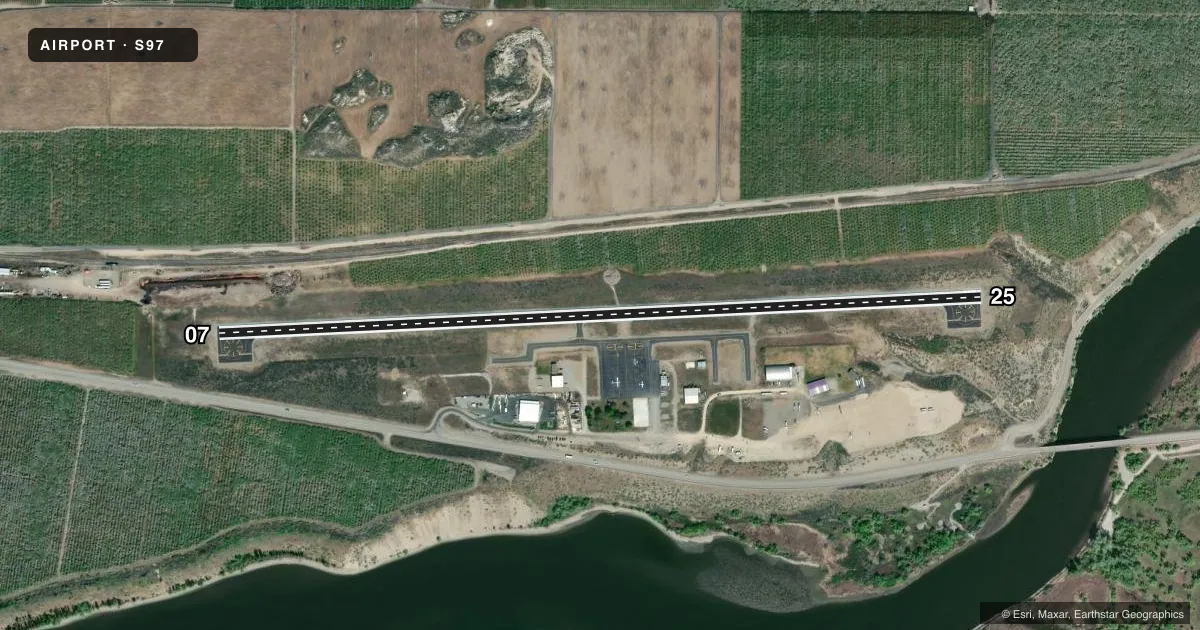
Full pagePattern entry · RWY 07
LEFT TRAFFICAirport sketch
Runways drawn to scale from FAA survey coordinates, rendered over satellite imagery. Not for navigation.
Approaches & charts
Services on the field
Fuel grades, oxygen, maintenance, ramp storage and lighting — as declared to the FAA by the airport operator.
Fuel & services
- Fuel
- Not available
- Oxygen (bottled)
- Not available
- Oxygen (bulk)
- Not available
- Airframe repair
- Not available
- Power plant repair
- Not available
- Other services
- AGRI,CHTR,INSTR,RNTL
Ramp & ground
- Transient storage
- Tie-down
- Landing fee
- No fee published
- Customs
- Not available
- Lighting schedule
- SEE RMK
- Beacon schedule
- SS-SR
- Beacon
- White / Green (civil land)(WG)
- Wind indicator
- Lighted
- Segmented circle
- Yes
Fuel & FBOs
Cheapest 100LL and Jet A on the field and nearby. Always confirm with the FBO before taxi.
Airport notes
Surface conditions, obstructions, local procedures, lighting outages and other notes published with each FAA cycle.
General notes
- TWY LGTS ON CNTR TWY ONLY.
- FOR CD CTC SEATTLE ARTCC AT 253-351-3694.
Lighting notes
- ACTVT MIRL RY 07/25 - CTAF.
Other notes
- TIE DOWN ROPES PILOT PROVIDES
- LIT IN NON-DAYLIGHT HOURS
VFR map & nearby airports
VFR sectional. Tap any ICAO chip to open that airport.
Key facts · S97
Answer card- ICAO
- S97
- Name
- ANDERSON FLD
- Location
- BREWSTER, WASHINGTON
- Elevation
- 919.5 ft MSL
- Traffic pattern altitude
- 1,919.5 ft MSL (1,000 AGL)
- Control tower
- Non-towered (use CTAF)
- Total runways
- 1
- Longest runway
- 07/25 · 4,000 ft
- Published ILS approaches
- 0
- Published frequencies
- 2
- Magnetic variation
- 20°
- Current flight rules
- VFR
- Current wind
- 160° at 12 kt
- Favored runway now
- RWY 07
Anderson Fld is in Brewster, Washington. The field elevation is 919.5 ft MSL. It has one runway, 07/25, which is 4,000 ft long and asphalt. There is no control tower. No ILS approaches are published. The pattern altitude is not published, so use standard 1,000 ft AGL for light piston traffic unless the current FAA Chart Supplement says otherwise.
The runway lights on 07/25 are medium intensity. They are activated by CTAF. Taxiway lights are on the taxiway centerline only. The wind indicator is lit during non-daylight hours. Pilot-provided tie down ropes are noted in the remarks. Plan to bring your own gear if you are parking overnight or for a longer stop.
There are no on-field FBOs listed. Contact the airport operator directly or call the field on CTAF or UNICOM for current service availability before you go. For clearance delivery, Seattle ARTCC is listed in the remarks at 253-351-3694. This is a small non-towered field. Expect self-announce traffic on 122.8. The runway is long enough for normal piston operations. Always check current weather, density altitude and runway condition before arrival. Brewster sits in north-central Washington. Keep terrain and local conditions in mind when planning your approach and departure.